

|
Helen F
Warrington |
1 of 45
Sat 13th May 2023 11:14am
A seemingly dry subject but full of data about the city from the 1850s onward. Coventry was noted for being rotten. It was overcrowded, stinking, filthy and decaying. The newspapers regularly had articles about how bad it was and that something must be done. One of the first steps must have been the creation of the magnificent Board of Health Maps Quantifying the problem but also capturing the city in a genuine work of art.
Following up there were annual reports written, starting in about 1875, that detailed the issues the city faced and what had been done to rectify them. Over the years they document the population, diseases, climate and the health problems caused by the structure of the city and what was done there. One of the issues they recognised was that many of the properties were 'back to backs' where two terraces shared a party wall such that there was no through draft. With coal fires this was particularly unhealthy and even directly dangerous. It made existing damp problems worse. One of the 'easiest' ways to rectify the problem was to merge the terraces and give people a front and back door. Also doubling a family's space. Of course this created a property shortage too, so progress was slow until the housebuilding efforts caught up with the ambitions.
Annual Health Reports
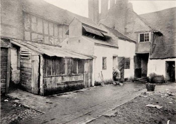
These pamphlets are a social researcher's gold mine. They offer a sobering picture of how hard life was and how modern medicine and protections should not be taken for granted. A particular nasty was the business of slaughtering animals. This wasn't hidden away in some large but discrete facility, it was dotted about the city in various courts. All the muck, gore and terrified animals were inflicted on the city's inhabitants. The most prolific slaughter house in the city was in Jordan Well, sharing the same yard as the old chapel, next to where Whitefriars Street was constructed and exactly where the first phase of the Gaumont was eventually built.
|
| Local History and Heritage - Health of the City | |
|
PeterB
Mount Nod |
2 of 45
Sat 13th May 2023 8:32pm
Now they improve health by re-routing buses
 Life Expectancy along the No.10 bus route.
 |
| Local History and Heritage - Health of the City | |
|
Mick Strong
Coventry |
3 of 45
Sun 14th May 2023 11:37am
Hi Helen, great post. But, do you think Coventry was any worse off than any other city at that time?
Mick Strong
|
| Local History and Heritage - Health of the City | |
|
Helen F
Warrington Thread starter
|
4 of 45
Mon 15th May 2023 10:42am
It's a good question Mick and the short answer is 'I don't know' but there are factors that could have made it worse at that particular time.
As I've mentioned before, Coventry had an odd progress due to the boom during the medieval wool era, then bust. It had a lot of very old buildings but they weren't the immediate problem. For centuries the city didn't need to expand or update because poverty and disease kept the population static or even falling. It wasn't really until the late 1600s that the population even matched its medieval high point but after that it did rocket. The common land rules prevented Coventry expanding much beyond the walls and the main roads such as Spon Street and Far Gosford. Those rules were eventually scrapped in the early 1800s but before that the only way Coventry could increase housing was to build along the gardens of the existing properties. The doors of medieval houses were often in direct line, front to back, so they often became entry ways to those courts/yards. The homes built in the courts were particularly poor and small. Water supply was extremely poor and sewerage even worse. The Medieval houses had relied on refuse pits and cess pits, which was doable with relatively low occupancy and a large, productive garden. Pig pens were often situated next to the out house for reasons I won't go into.
 but none of that worked when the yards began to fill up. Initially pipes would have gone into the river, making it an utter sewer, despite rules no doubt in place to prevent it. The first stage cleaning things up came before 1850, removing some of the mill ponds eg Priory Mill and the one at the end of Cox Street - the Bastille Mill. More of the mills were removed as the problem remained. So at least the problem was washing away faster. At the same time they were trying to clean things up, businesses with industrial pollution were springing up. To introduce decent pipework and sewerage required space, investment and co-operation with owners and inhabitants. An area of particularly poor housing was in the quadrant behind Bishop Street to Hales Street. It had more than its share of housing built between 1700 and 1800. There are remarks in the health pamphlets acknowledging that they couldn't evict people before there was somewhere for them to go. Progress at first was very slow and the same properties are recorded year after year. Owners were reluctant to spend money and/or lose existing renters. As with the Jordan Well properties, the owners sometimes got a better offer to redevelop the area entirely and voluntarily closed, evicting themselves and/or others.
On the plus side, a lot of Coventry was only two storey. It didn't have the precariously tall streets that London had. The areas with taller buildings were wealthier, better built and maintained or upgraded. The low rise buildings could only hold so many people, so the situation could have been much worse. Coventry had avoided major fires, which was good in one way but devastation often leads to a fresh start. Looking at the old photographs it's sometimes easy to mistake demolition for bomb damage and at times the impact of slum clearance must have merged with memories of the war because entire blocks vanished, with the people gone as well as the familiar views. Progress can still feel traumatic.
Looking through the pamphlets the clearances get a lot more systematic and ambitious as time went on. Businesses seem to have encouraged the process as they started to fill up the vacant spaces. The more modern but no longer useful top shops also became viable targets for demolition. While in modern times people would have expanded their living space upwards, the top floors seemed to have become derelict and abandoned and in some cases they were removed, reducing the properties to two storey properties. I don't get the impression that this was common because the move out of the city centre was in full swing by then.
Coventry's mixed financial success would have played its part. Often if a place is poor, there's just not the civic money to improve things. Coventry didn't have the Roman engineering to build upon or the Georgian boom to build better.
So possibly not the worst city but perhaps it was later than other cities to clean up its act? but none of that worked when the yards began to fill up. Initially pipes would have gone into the river, making it an utter sewer, despite rules no doubt in place to prevent it. The first stage cleaning things up came before 1850, removing some of the mill ponds eg Priory Mill and the one at the end of Cox Street - the Bastille Mill. More of the mills were removed as the problem remained. So at least the problem was washing away faster. At the same time they were trying to clean things up, businesses with industrial pollution were springing up. To introduce decent pipework and sewerage required space, investment and co-operation with owners and inhabitants. An area of particularly poor housing was in the quadrant behind Bishop Street to Hales Street. It had more than its share of housing built between 1700 and 1800. There are remarks in the health pamphlets acknowledging that they couldn't evict people before there was somewhere for them to go. Progress at first was very slow and the same properties are recorded year after year. Owners were reluctant to spend money and/or lose existing renters. As with the Jordan Well properties, the owners sometimes got a better offer to redevelop the area entirely and voluntarily closed, evicting themselves and/or others.
On the plus side, a lot of Coventry was only two storey. It didn't have the precariously tall streets that London had. The areas with taller buildings were wealthier, better built and maintained or upgraded. The low rise buildings could only hold so many people, so the situation could have been much worse. Coventry had avoided major fires, which was good in one way but devastation often leads to a fresh start. Looking at the old photographs it's sometimes easy to mistake demolition for bomb damage and at times the impact of slum clearance must have merged with memories of the war because entire blocks vanished, with the people gone as well as the familiar views. Progress can still feel traumatic.
Looking through the pamphlets the clearances get a lot more systematic and ambitious as time went on. Businesses seem to have encouraged the process as they started to fill up the vacant spaces. The more modern but no longer useful top shops also became viable targets for demolition. While in modern times people would have expanded their living space upwards, the top floors seemed to have become derelict and abandoned and in some cases they were removed, reducing the properties to two storey properties. I don't get the impression that this was common because the move out of the city centre was in full swing by then.
Coventry's mixed financial success would have played its part. Often if a place is poor, there's just not the civic money to improve things. Coventry didn't have the Roman engineering to build upon or the Georgian boom to build better.
So possibly not the worst city but perhaps it was later than other cities to clean up its act? |
| Local History and Heritage - Health of the City | |
|
NeilsYard
Coventry |
5 of 45
Mon 15th May 2023 11:38am
Brilliant as ever Helen - though I've lost my bearings - I thought the Chapel was Gosford St North side?
|
| Local History and Heritage - Health of the City | |
|
Helen F
Warrington Thread starter
|
6 of 45
Mon 15th May 2023 11:53am
That was a different one Neil. This was much older. There was another on Whitefriars Lane too.
|
| Local History and Heritage - Health of the City | |
|
Choirboy
Bicester |
7 of 45
Mon 15th May 2023 12:15pm
According to the Nottingham Post, Nottingham's slums were considered the worst in Europe, probably caused by the same reasons Helen gives above. Namely, the lack of space for expansion because of the city's common land. There is an excellent resource at british-history that outlines Coventry's Public Services from medieval times to the present.
|
| Local History and Heritage - Health of the City | |
|
Helen F
Warrington Thread starter
|
8 of 45
Mon 15th May 2023 12:28pm
On 15th May 2023 11:38am, NeilsYard said:
Brilliant as ever Helen - though I've lost my bearings - I thought the Chapel was Gosford St North side?
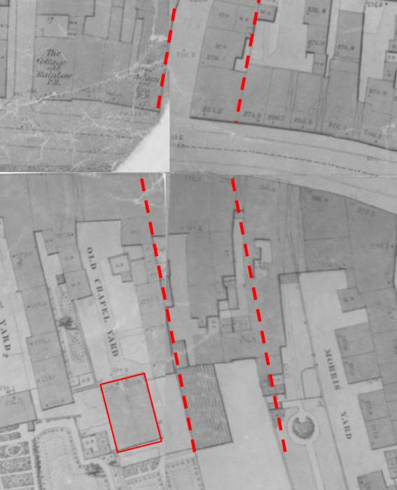
Right at the junction of the 4 maps. The chapel is marked in red lines. In 1850 it looked like it was divided into two residences but by the 1900s I believe it was subdivided again into four. Widened Cox Street and the then new Whitefriars Street in red dashes.
|
| Local History and Heritage - Health of the City | |
|
NeilsYard
Coventry |
9 of 45
Mon 15th May 2023 2:05pm
So just to the right and behind off camera from this one then?
|
| Local History and Heritage - Health of the City | |
|
Helen F
Warrington Thread starter
|
10 of 45
Mon 15th May 2023 2:28pm
Exactly.
 |
| Local History and Heritage - Health of the City | |
|
Dreamtime
Perth Western Australia |
11 of 45
Mon 15th May 2023 6:12pm
Fascinating reading folks, thank you.
|
| Local History and Heritage - Health of the City | |
|
Helen F
Warrington Thread starter
|
12 of 45
Mon 29th May 2023 11:46am
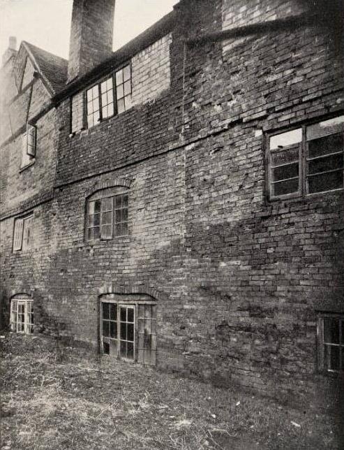
Another image from the health reports. I'm not 100% sure about the location of this one but I think that it's Court 27 on Much Park Street. The buildings don't seem to have had doors on that side. There are very few clues to locate it other than the soil build up against the wall. Even 60 years before the photo was taken there was a 2ft 3" difference between the interior floor level and the soil at the back. The land would have been cultivated for some of that period and it may well have gained humus and rubbish in that time, raising the soil level even further. While some properties were improved and returned to use, this block was demolished because there was little that could be done to remedy the severe damp problems caused by the soil level. It looks like it might have fallen down before long anyway.
|
| Local History and Heritage - Health of the City | |
|
Helen F
Warrington Thread starter
|
13 of 45
Thu 29th Jun 2023 6:39pm
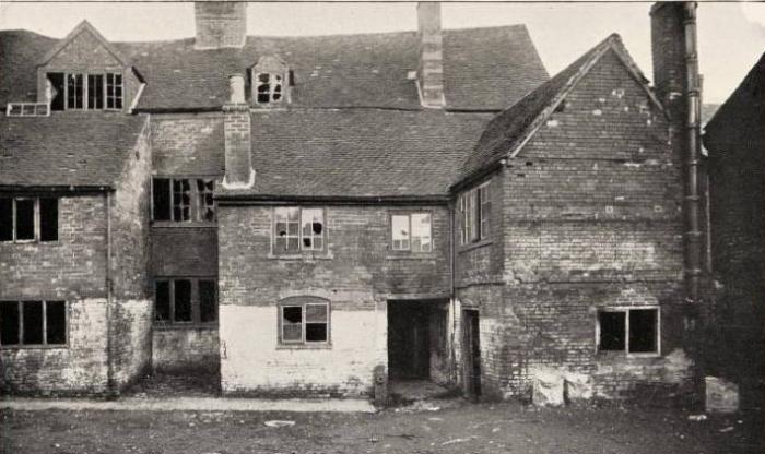
Here is an example of an ancient 3 storey timber range from the rear, that had been extended with 2 story blocks. At some point the owners had decided to split the fronts from the backs to create more properties, thus stopping any through draft. The properties were deemed unsuitable for habitation until the owner reversed the bright idea. Took me ages to work these out but I'm now sure that this is court 9 on Grey Friars Lane. Either this picture was mid refurbish or pre demolition but their return to the housing stock wasn't for long because the block was replaced a couple of decades later.
|
| Local History and Heritage - Health of the City | |
|
NeilsYard
Coventry |
14 of 45
Fri 30th Jun 2023 11:17am
Fantastic image Helen - really shows you the state these Courts were in. Is there a Map with that Court marked I can look at?
|
| Local History and Heritage - Health of the City | |
|
Helen F
Warrington Thread starter
|
15 of 45
Fri 30th Jun 2023 12:04pm
Top left hand corner, looking east behind the west hand side of the road. There's a new little slider option on the expanded map. When you compare the tiny blocks on the map with the large building in the photo, you realise how many buildings the city contained. I was looking for a much bigger footprint. I digitally wandered up and down Spon Street, Gosford Street and others with no success.
|
| Local History and Heritage - Health of the City | |

Website & counter by Rob Orland © 2026