PhiliPamInCoventry
Holbrooks
|
1 of 260
Fri 10th Feb 2012 10:40am
Hi all 
Many people do not know that we have a river flowing through the middle of our city, even some people that live here do not know about its existence. Stratford upon Avon has the theme of its river both in the town & its title. Water features are very popular in gardens where we pay to have them installed, but in Coventry we hide our river underground from the point where it leaves Spon End, (with one minor exception) not to reappear until the Gulson Rd area, and there it is not easily seen. Property developers have moved in at canal side venues with very attractive looking appartments & housing. Could not a central section of our river be opened up with an attractive river-side cafe, bar or similar? I know that there are a lot of issues involved with this, keeping it clean & tidy, & when our city was being re-built after the war, water infections like polio were big health issues. Could you see yourself having a waterside breakfast or an afternoon tea with the River Sherbourne flowing by?
From Wiki--:
The River Sherbourne is a river that flows under the centre of the city of Coventry, West Midlands, England.
|
|
Local History and Heritage -
River Sherbourne and tributaries
|
NeilsYard
Coventry
|
2 of 260
Fri 10th Feb 2012 2:28pm
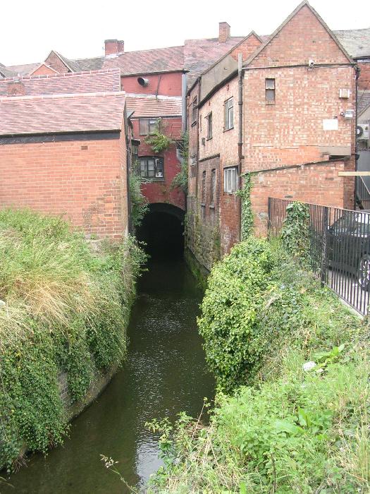
Philip, I'm sure there was a plan to open up the Sherbourne when they knocked down the Smithfield pub. What's now a piece of grass opposite the Motor Museum and up alongside Palmer Lane (probably the only place in the city centre the water is visible) were supposed to be a river walk. Not sure what happened.
|
|
Local History and Heritage -
River Sherbourne and tributaries
|
PhiliPamInCoventry
Holbrooks
Thread starter
|
3 of 260
Fri 10th Feb 2012 3:28pm
Hello Neil, & thank you.
By going to the street maps-select on here, covmaps and starting from the oldest & coming forward in time we can see how it has disappeared under our streets. |
|
Local History and Heritage -
River Sherbourne and tributaries
|
dutchman
Spon End
|
4 of 260
Fri 10th Feb 2012 3:28pm
There was plan at one to time to create a walkway alongside the river running from Spon End to the city centre but nothing ever came of it. Even the proposed footbridge at the end of Sherbourne Street was abandoned.
There is a bit of footpath running behind the garage and pub car park but it's become a dumping ground for fly tippers  |
|
Local History and Heritage -
River Sherbourne and tributaries
|
Greeny
Coventry
|
5 of 260
Sat 11th Feb 2012 11:32pm
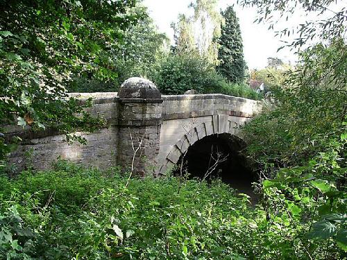
Here's a recent image of the river behind the Burges, apparently there was a ford around here in medieval times.
Guess if you could walk the culverted river it would be like archaeology without the digging! |
|
Local History and Heritage -
River Sherbourne and tributaries
|
Rob Orland
Historic Coventry
|
6 of 260
Sat 11th Feb 2012 11:56pm
On 11th Feb 2012 11:32pm, Greeny said:
Guess if you could walk the culverted river it would be like archaeology without the digging!
An interesting idea... and indeed one that's been done by a pair of innovative urban explorers. You might like to see their report of their journey along the underground Sherbourne on this page
|
|
Local History and Heritage -
River Sherbourne and tributaries
|
Greeny
Coventry
|
7 of 260
Sun 12th Feb 2012 12:23am
Thanks Rob... ahh the 28 Days Later site - excellent ! Although I've never seen this one before.
I got the idea from reading Lost Rivers Of London book by Nicholas Barton. He mentions when they culverted the River Fleet they just covered it over, so all the old jetties and hulks of old barges are still to be seen down there.
Me and a friend did a sort of 28 Days Later in the late 70s behind the Coventry Halfpenny (between the bottom of the Burges and Palmer Lane - old buildings untouched since the mid-50s, all since demolished.
|
|
Local History and Heritage -
River Sherbourne and tributaries
|
PhiliPamInCoventry
Holbrooks
Thread starter
|
8 of 260
Sun 12th Feb 2012 12:02pm
Hi & thank you both for that.
Viewing the Coventry maps on here, coming forward in time reveals so much, particularly the Sherbourne. Just that one spot of blue left. A few years ago, I walked the way of the Sherbourne where it was walkable along its entire length. A college friend did the same & recorded some of these pics on Flickr.
|
|
Local History and Heritage -
River Sherbourne and tributaries
|
Baz
Coventry
|
9 of 260
Sun 27th May 2012 10:44pm
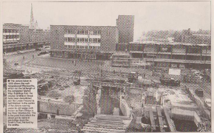
Just in view is the old tunnel of the river Sherbourne. This is now where the ramp to the lower shops are. 
Always looking forward to looking at the past.
|
|
Local History and Heritage -
River Sherbourne and tributaries
|
dutchman
Spon End
|
10 of 260
Sun 27th May 2012 10:54pm
Good find Baz! 
It was offically known as "Ram Bridge" which carried Smithford Street over the river. Note also the last remnant of West Orchard on the extreme right where it joined Fleet Street. The waste ground in-between had once been the pre-war Co-op. |
|
Local History and Heritage -
River Sherbourne and tributaries
|
PhiliPamInCoventry
Holbrooks
Thread starter
|
11 of 260
Mon 28th May 2012 8:22am
Hi to you both & Hi all
A fabulous bit of info, indeed. Bril! |
|
Local History and Heritage -
River Sherbourne and tributaries
|
Radford kid
Coventry
|
12 of 260
Mon 28th May 2012 9:05am
|
|
Local History and Heritage -
River Sherbourne and tributaries
|
dutchman
Spon End
|
13 of 260
Mon 28th May 2012 1:36pm
There were similar problems with flooding of the basement from the river when the store was first built. City Engineers also discovered wooden piles dating back to Saxon times.
|
|
Local History and Heritage -
River Sherbourne and tributaries
|
Baz
Coventry
|
14 of 260
Mon 18th Jun 2012 9:06pm
On 28th May 2012 9:05am, Radford kid said:
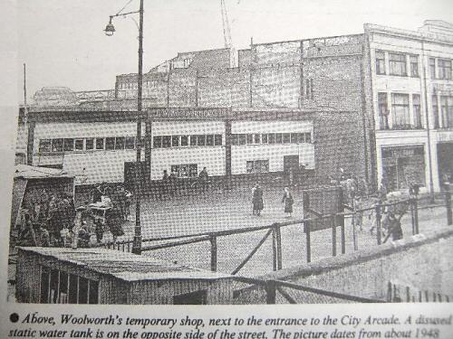
I sure remember them building Woolies, and I think I remember the makeshift Woolies made out of corrugated steel sheets? Maybe someone will put me right on that one.
It took soon time to find, but this may be it
Always looking forward to looking at the past.
|
|
Local History and Heritage -
River Sherbourne and tributaries
|
dutchman
Spon End
|
15 of 260
Mon 18th Jun 2012 10:58pm
Thanks for that Baz, it's the best view I've seen of the temporary Woolies.
The static water tank was the basement of the bombed-out Marks & Spencer. I've read that it later became the basis of the toilets in the Upper Precinct but I've studied maps and photgraphs and am not 100% convinced of that. |
|
Local History and Heritage -
River Sherbourne and tributaries
|


