


|
Janeyb
Northamptonshire |
1 of 6
Tue 9th Aug 2016 10:01pm
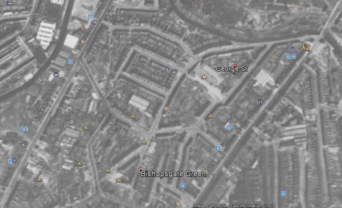
Looking on Street View for 77 George Street CV1 there are a lot of even numbered houses missing and a school in their place. Please can a knowledgeable local tell me why.
|
| Streets and Roads - George Street | |
|
PeterB
Mount Nod |
2 of 6
Wed 10th Aug 2016 12:50am
Janeyb,
Looking at www.oldmaps.co.uk, there were never any houses actually on the dog-leg in George Street which was an entrance to John Gulson Primary School. The houses on the south side of the dog leg are shown on the 1969 OS map (and on the 1972 "Russian" map), but have disappeared by the 1977-82 map which shows the school having extended behind where the houses were. Looking at Google satellite view the houses were on what is now a tarmaced playground.
Hopefully others can help with the detail, but it looks like the houses were demolished when the school was extended.
Peter.
|
| Streets and Roads - George Street | |
|
Janeyb
Northamptonshire Thread starter
|
3 of 6
Wed 10th Aug 2016 10:30am
Thanks PeterB that's sort of what I thought but didn't want to jump to conclusions.
 |
| Streets and Roads - George Street | |
|
Annewiggy
Tamworth |
4 of 6
Wed 10th Aug 2016 10:58am
From the newspaper archive the council were discussing purchasing 4,420 sq yards of land for £1,500 for an extension to the John Gulson School
|
| Streets and Roads - George Street | |
|
Annewiggy
Tamworth |
5 of 6
Wed 10th Aug 2016 12:09pm
Sorry not very clear, from Google Maps 1945
|
| Streets and Roads - George Street | |
|
pixrobin
Canley |
6 of 6
Wed 10th Aug 2016 1:10pm
This is from the 1926 OS Map
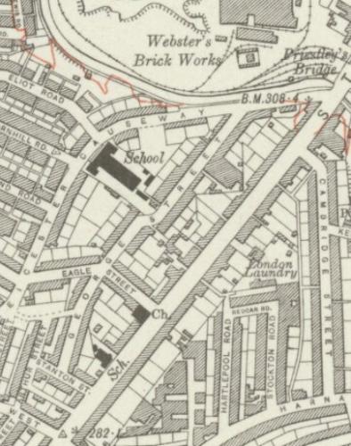 Reproduced with the permission of the National Library of Scotland
http://maps.nls.uk/index.html
Reproduced with the permission of the National Library of Scotland
http://maps.nls.uk/index.html
|
| Streets and Roads - George Street | |

Website & counter by Rob Orland © 2026