Can I ask again for help in finding out where Brewery Street in Coventry was/is? My GG Grandfather James COLE lived there on the 1841 Census with his wife Jane and son James. James' occupation is stated as Draughtsman. I'm wondering whether this is an occupation in a Brewery perhaps of that time?
Question
Streets and Roads - Brewery Street
Annewiggy Tamworth
2 of 8Wed 27th Apr 2016 5:29pm
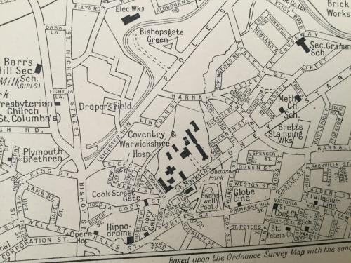
Hi Coventry49. Brewery Street is between Leicester Street and Henry Street just above where it says Cook Street Gate on this map. Hope that helps.
Streets and Roads - Brewery Street
coventry49 Budleigh Salterton, Devon
Thread starter
3 of 8Wed 27th Apr 2016 6:19pm
Many thanks Anne. In my mind I can just about work out where it was. I take it that it disappeared years ago?
Streets and Roads - Brewery Street
Annewiggy Tamworth
4 of 8Wed 27th Apr 2016 6:53pm
On later census he appears to be in the weaving industry. I think maybe a draughtsman is something to do with that. Probably the person who does the designs. In 1881 when he is 76he is employing 2 men and 2 women.
Streets and Roads - Brewery Street
dutchman Spon End
5 of 8Wed 27th Apr 2016 8:58pm
That whole area was massively bombed, left derelict for decades after the war then finally submerged under the new Ring Road:
Streets and Roads - Brewery Street
coventry49 Budleigh Salterton, Devon
Thread starter
6 of 8Thu 28th Apr 2016 8:10am
Thank you Dutchman. I will go into Britain from Above and zoom in on that particular photograph and see if I can identify Brewery Street. The system of building homes around Courts was obviously common in Coventry at a certain period of time. I do remember seeing them in my childhood and well into the late 1960s in Spon End particularly.
Streets and Roads - Brewery Street
dutchman Spon End
7 of 8Thu 28th Apr 2016 6:17pm
I'm afraid that's as zoomed-in as you can get on Britain From Above in 1939 and by 1946 the area looked like this:
Streets and Roads - Brewery Street
coventry49 Budleigh Salterton, Devon
Thread starter
8 of 8Thu 28th Apr 2016 7:09pm
Thanks Dutchman
I can get my bearings from the Hippodrome and the corner of Trinity Street and see all the flattened area behind that.