
|
Jim Blasingame
USA |
1 of 13
Wed 16th Mar 2016 9:02pm
Greetings from America. I have another question for my book research. Does anyone have a map of the roads in and out of ancient Coventry? I've seen the city map on this website, but it doesn't show how folks traveled to other places. If you don't have a map, any listing of roads to places like Feldon, London, Bristol, etc. Especially W, E and S. I've looked, but haven't found it. Anything during the Medieval times would be perfect. Thanks, Jim
Jim Blasingame
|
| Streets and Roads - Ancient Coventry roads | |
|
PhiliPamInCoventry
Holbrooks |
2 of 13
Wed 16th Mar 2016 9:18pm
Greetings to you Jim & welcome to our forum.
 Thank you for your post.
  |
| Streets and Roads - Ancient Coventry roads | |
|
flapdoodle
Coventry |
3 of 13
Wed 16th Mar 2016 9:55pm
I've read recently that there is evidence of a Roman road on Cox Street and a Roman ditch in Hillfields. Perhaps a Roman road that ran from Mancetter down to Baginton.
|
| Streets and Roads - Ancient Coventry roads | |
|
Jim Blasingame
USA Thread starter
|
4 of 13
Wed 16th Mar 2016 9:59pm
Any idea what road would have led to the Feldon area?
Jim Blasingame
|
| Streets and Roads - Ancient Coventry roads | |
|
Helen F
Warrington |
5 of 13
Thu 17th Mar 2016 12:14am
The oldest map with Coventry on it I know of is the Gough map. There is a search function. The map is at 90 degrees to normal.
Gough map of the UK
Big jpg version
I'm not sure where Feldon is but the A roads follow much the same routes they always did. If Feldon is on the way to a major medieval town, that would be the road they took. eg Warwick Road or the London Road.
|
| Streets and Roads - Ancient Coventry roads | |
|
Midland Red
|
6 of 13
Thu 17th Mar 2016 8:53am
This may help
 |
| Streets and Roads - Ancient Coventry roads | |
|
Helen F
Warrington |
7 of 13
Thu 17th Mar 2016 10:37am
From 1510 there are the John Speed maps
John Speed Warwickshire
Another interesting map (1580s) is the Sheldon Tapestry Map. There's a zoomable link at the site.
Sheldon Tapestry Map
It doesn't show roads but it does show the major towns at that time. eg Bromicham (old Birmingham) is smaller than Coventry.
|
| Streets and Roads - Ancient Coventry roads | |
| Old Lincolnian |
8 of 13
Thu 17th Mar 2016 2:51pm
|
|
Annewiggy
Tamworth |
9 of 13
Fri 18th Mar 2016 4:23pm
Some time ago I bought a collection of "Coventry stuff" off an old gentleman who lived in Bonds Hospital and volunteered alongside my mum at the Myton Charity shop.There are a few different maps in the box that he had obviously been researching at the time. This is one that he has done which shows Latin names and some dates titled "Suggested reconstruction of an early plan of Coventry (from documentary evidence before 1340)." I do not know anything about this but I thought I would share his research for anyone interested.
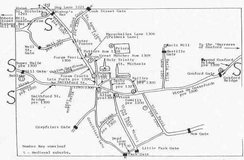 These are notes that accompany the map
Key to the reconstructed early plan of Coventry
1. Described as "vicus ubi pulterie venditur versus portam prioratus.r,
2. A 'smithy' in the 'market place' - pre 1300 deed. A disputed wall too close to a neighbours oven. 1290.
3. Plots of land run down to the Red Ditch. - late 13th. cent. (Not built on because ditch not yet filled in)
4. "Before the Prior's Door" 1202
5. Site of the 'White Cellar' ('Magnus Vicus facing)
6. Tenement "leading to the Earl's Orchard" - 1309.
7. A Mill "by the park" - 1252
8. Site of Jordan Well. Not yet given to a street.
9. Street from the Bars' to Radford - 1296
10. "In bivio de coventr' versus ecclesiam S Nicholai" - 12th. cent.
11. Babbelake chapel ,"Newlyformed" in 1344
Note on the compilation of the map.
For lay-out of the streets Bradford's and speed's maps have been used. Details of location derived from documents in the Corporation records, P.R.O. Calendar of Ancient Deeds and the Feet of Fines.
Street names taken from an early and distinctive or Latinised form, where it is known: otherwise the modern conventional form is used.
Gates are indicated from the later system of walls - not all may have existed at this period. Acknowledgement to the Grossary in the Coventry section of the Victoria County History of Warwickshire (compiled by Joan C Lancaster and the Editorial staff).
These are notes that accompany the map
Key to the reconstructed early plan of Coventry
1. Described as "vicus ubi pulterie venditur versus portam prioratus.r,
2. A 'smithy' in the 'market place' - pre 1300 deed. A disputed wall too close to a neighbours oven. 1290.
3. Plots of land run down to the Red Ditch. - late 13th. cent. (Not built on because ditch not yet filled in)
4. "Before the Prior's Door" 1202
5. Site of the 'White Cellar' ('Magnus Vicus facing)
6. Tenement "leading to the Earl's Orchard" - 1309.
7. A Mill "by the park" - 1252
8. Site of Jordan Well. Not yet given to a street.
9. Street from the Bars' to Radford - 1296
10. "In bivio de coventr' versus ecclesiam S Nicholai" - 12th. cent.
11. Babbelake chapel ,"Newlyformed" in 1344
Note on the compilation of the map.
For lay-out of the streets Bradford's and speed's maps have been used. Details of location derived from documents in the Corporation records, P.R.O. Calendar of Ancient Deeds and the Feet of Fines.
Street names taken from an early and distinctive or Latinised form, where it is known: otherwise the modern conventional form is used.
Gates are indicated from the later system of walls - not all may have existed at this period. Acknowledgement to the Grossary in the Coventry section of the Victoria County History of Warwickshire (compiled by Joan C Lancaster and the Editorial staff). |
| Streets and Roads - Ancient Coventry roads | |
|
Jim Blasingame
USA Thread starter
|
10 of 13
Mon 21st Mar 2016 10:29pm
Thank you for the helpful responses, everyone. If you have other road information, thank you for posting it. Jim
Jim Blasingame
|
| Streets and Roads - Ancient Coventry roads | |
|
charabanc
Coventry |
11 of 13
Mon 21st Mar 2016 11:42pm
Hello Jim The main road out to the west and north-west, leaving the central area through Spon End, was the Allesley Old Road, otherwise known as Old Birmingham Road or Birmingham Old Road. Its replacement as the main route was designed by Thomas Telford and named Holyhead Road in recognition of the principal destination, especially for travellers wishing to sail to Ireland. Telford lowered the access road to Allesley, to help the horses on the coaching route and also the steam coaches which had to climb the slope. That is why you can see what appear to be elevated frontages in the older part of the village which actually indicate the original level of the road, with the steps being built to descend to the new road level. The opposite process was conducted in Meriden, where the road descended steeply to The Queen's Head before rising again. Telford built an elevated stretch of road to pass the inn at a higher level, again to help the horses.
|
| Streets and Roads - Ancient Coventry roads | |
|
Helen F
Warrington |
12 of 13
Tue 22nd Mar 2016 9:04am
Things speeded up once coaching roads were set up. The Allesley Old Road was also part of the Holyhead Road that you can trace from Coventry to the Wirral on Google. The current Holyhead road near St John's is new. At the time Jim is interested in, the Allesley road was probably called the Chester Road because Chester was the main port in that area, not Holyhead. It's not a given that the Earls of Chester were based there but it would have been a prominent centre. While eventually coaching inns could swap horses for coach travellers allowing longer spates of travel, in Jim's chosen era, riders probably travelled between 15 and 30 miles a day depending on the makeup of the travelling group. Normally they would have moved from one settlement to another because sleeping in the open was dangerous. People would not travel directly to London, they'd probably travelled to Daventry first, then somewhere near Bletchley or as far as Dunstable. Then St Albans maybe, before making the last stretch to London. Those jumps may have been shorter if weather was bad, especially in winter and after a few days riding, they may have rested for a day at one of the stops, especially if they were going to fight at their final destination.
|
| Streets and Roads - Ancient Coventry roads | |
| PhiliPamInCoventry |
13 of 13
Tue 22nd Mar 2016 12:13pm
|

Website & counter by Rob Orland © 2026
