
|
pixrobin
Canley |
1 of 49
Sat 12th Jul 2014 3:23pm
The title of Westwood Parish is used for convenience. It is the only way that describes the parcel of land that I wish this topic to be about. Until 1926 it formed part of Lord Leigh's estate to the south west and west of Coventry. It included the hamlets of Canley, Westwood, Bockenden, Tile Hill, Fletchamstead, and Whoberley.
The area has seen significant development both in the immediate pre-war period and the post-war period through to the present day which made a large contribution to the city of Coventry. During the war years it contained many hostel developments to house workers in local factories. It also has a history of its own, away from the hustle and bustle of crowded city life.
For centuries the land was worked mainly by tenant farmers employing their own agricultural labourers. Brian Devine writing in the Coventry Standard in 1960 suggests of Fletchamstead "Years ago the whole area was divided up into two farms, Silk's and Capel's." From memory Capel's farm was situated at the old Fletchamstead Hall, but I have no memory of Silk's farm. Can anyone help with the latter.
|
| Coventry Suburbs and Beyond - Westwood Parish (incl. Land Ownership and Development) | |
|
Annewiggy
Tamworth |
2 of 49
Sat 12th Jul 2014 7:38pm
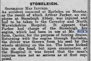
This is the only reference I can find to Silk's Farm on the newspaper archive
|
| Coventry Suburbs and Beyond - Westwood Parish (incl. Land Ownership and Development) | |
|
Annewiggy
Tamworth |
3 of 49
Sat 12th Jul 2014 8:00pm
On the 1911 census there is an Arthur Silk, farmer, Fletchamstead. It is listed next to Whoberley Hall. Arthur Silk was born in Nether Whitacre
Arthur Silk died in 1918 and was buried at Nether Whitacre. He had previously farmed at Gibbett Hill.
|
| Coventry Suburbs and Beyond - Westwood Parish (incl. Land Ownership and Development) | |
|
pixrobin
Canley Thread starter
|
4 of 49
Sat 12th Jul 2014 9:43pm
Thanks Anne - any idea of date of newspaper article?
Question |
| Coventry Suburbs and Beyond - Westwood Parish (incl. Land Ownership and Development) | |
|
Annewiggy
Tamworth |
5 of 49
Sat 12th Jul 2014 9:58pm
Sorry Pixrobin 1913
I have just found this site fletchamstead hall
I think this is the same place as Mr Harriss put it up for sale in 1900. Arthur Silk was at Gibbett Hill in 1891 but at Fletchamstead in 1901.
|
| Coventry Suburbs and Beyond - Westwood Parish (incl. Land Ownership and Development) | |
|
pixrobin
Canley Thread starter
|
6 of 49
Sun 13th Jul 2014 12:25am
Thanks Anne - brilliant site for my research
|
| Coventry Suburbs and Beyond - Westwood Parish (incl. Land Ownership and Development) | |
|
pixrobin
Canley Thread starter
|
7 of 49
Fri 18th Jul 2014 6:06pm
Looking into this area I have noted that many of the farms were approx 230 - 270 acres. Being brought up a Canley kid and not one of the landed gentry
 I was having difficulty imagining what that actually looked like, and something common to most Coventrians. The War Memorial Park is 48.5 Hectares which is approximately 120 Acres (1 Hectare = 2.47105 acres). So the farms I have been looking at worked an area around twice the size of the Memorial Park. I was having difficulty imagining what that actually looked like, and something common to most Coventrians. The War Memorial Park is 48.5 Hectares which is approximately 120 Acres (1 Hectare = 2.47105 acres). So the farms I have been looking at worked an area around twice the size of the Memorial Park. |
| Coventry Suburbs and Beyond - Westwood Parish (incl. Land Ownership and Development) | |
|
Mike H
London Ontario, Canada |
8 of 49
Fri 18th Jul 2014 7:45pm
Get you wi' yer fancy 'hectares' and Memorial Park
The poor sods in Coundon were grounded if they dallied beyond the 'wedge', and those living topside of Longford Rd, the Memorial Park would have been like going to America, it were that big..  |
| Coventry Suburbs and Beyond - Westwood Parish (incl. Land Ownership and Development) | |
|
pixrobin
Canley Thread starter
|
9 of 49
Fri 18th Jul 2014 9:11pm
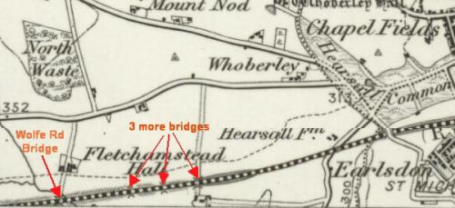 From the map as well as the Wolfe Road bridge there are three other bridges under the railway. (Map is dated 1899) Of all the hours of my childhood (early 1950s) I spent playing on those fields I remember only one in addition to the one marked Wolfe Rd. I think the one I remember is the left-hand one, which in my chilhood came out to the rear of the Co-op Model Bakery. Did anyone see any signs of the others.
 |
| Coventry Suburbs and Beyond - Westwood Parish (incl. Land Ownership and Development) | |
|
pixrobin
Canley Thread starter
|
10 of 49
Mon 25th Aug 2014 12:24am
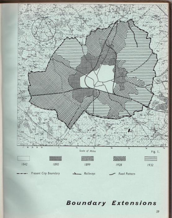
In the British History Online it notes " Westwood, with its hamlets of Fletchamstead, Canley, and Tile Hill, was included within the city boundary in 1927, and other parts of the parish were added under the Coventry Extension Act of 1931."
What was the Coventry extension Act of 1931 and what were the 'other parts'?
Question |
| Coventry Suburbs and Beyond - Westwood Parish (incl. Land Ownership and Development) | |
|
Annewiggy
Tamworth |
11 of 49
Mon 25th Aug 2014 10:54am
Pixrobin. This may be of some help. This is from the book "Coventry the development plan 1951" so the "Present City Boundary would refer to that date.
|
| Coventry Suburbs and Beyond - Westwood Parish (incl. Land Ownership and Development) | |
|
morgana
the secret garden |
12 of 49
Mon 25th Aug 2014 11:04am
The Leigh family of Stoneleigh owned Westwood Heath school. Photo of the pld school.
LINK
|
| Coventry Suburbs and Beyond - Westwood Parish (incl. Land Ownership and Development) | |
|
pixrobin
Canley Thread starter
|
13 of 49
Mon 25th Aug 2014 4:14pm
Yes Morgana, my mother attended Westwood School from 1913-1916. She left school at the age of 12. I was the youngest in our family, born a couple of months prior to her 40th birthday.
|
| Coventry Suburbs and Beyond - Westwood Parish (incl. Land Ownership and Development) | |
|
pixrobin
Canley Thread starter
|
14 of 49
Mon 25th Aug 2014 4:51pm
From what I can make out of the 'green-belt' shapes on the map (printed in the Coventry Telegraph) to be developed it looks as though Park Wood and Ten Shilling Wood are going to disappear under plans for new housing. Both have been previously described as ancient woodland.
 If you go down to the woods today you're in for a big surprise
The council seem to suggest it's a site for six high-rise
If you go down to the woods today you're in for a big surprise
The council seem to suggest it's a site for six high-rise |
| Coventry Suburbs and Beyond - Westwood Parish (incl. Land Ownership and Development) | |
|
pixrobin
Canley Thread starter
|
15 of 49
Tue 26th Aug 2014 11:25am
Seems to be a bit of confusion with historic land owners here. Prior to 1926 Westwood was owned by Lord Leigh of Stoneleigh. Farmers were tenant farmers not farm owners. Any new buildings the farmer required had to be approved by the Stoneleigh estate but initially paid for by the farmer, or sometimes a split with the Leighs providing the materials and the farmer paying for the construction. An adjustment would be made at the end of the tenancy for any increase in farm value. It may have been this arrangement that drove farmer William Wakefield (Fletchamstead Hall) into bankruptcy by 1881.
The area being the property of one land-owner would have meant that the purchase by Coventry Corporation in 1926 would have eased negotiations compared to having to negotiate with the individual farmers.
|
| Coventry Suburbs and Beyond - Westwood Parish (incl. Land Ownership and Development) | |

Website & counter by Rob Orland © 2026
