

|
Helen F
Warrington |
31 of 36
Tue 31st Dec 2024 1:07pm
I keep forgetting about that woman. Thanks Anne. So more like this then. Any depth to the Radford Brook then was backflow from the mill pond.
|
| Memories and Nostalgia - Babbu Lacu - Medieval Crossings and Lost Roads | |
|
Bob
Thread starter
|
32 of 36
Tue 31st Dec 2024 7:22pm
Hello Helen, Annewiggy and PhiliPamIn, (I am being a bit slow, responding to posts 19 to 25 as follows)
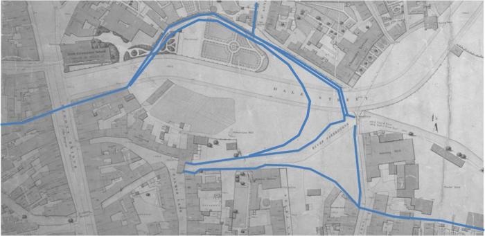
Thank you for all for the information. Nice drawing of the Gosford St bridge and surrounding buildings. I like the network diagram of rivers streams and pools. Thanks for the clarification of Catesby Lane and the detail supporting an adjusted alignment of Radford Brook. I have a few thoughts on pools, mills and rivers picking up your comments.
The Bradford Map of 1750 appears to include a more logical joining of the Radford Brook and River Sherbourne near the bottom of West Orchard. This is not shown on Speed's map, but the 1610 map is sometimes lacking in detail and accuracy. As suggested the Radford Brook seems to follow an artificial line roughly parallel to the River Sherbourne for about 500m down to Priory Pool and this can be seen on the 1750 map in particular. I agree that intervention to improve drainage looks likely so assume the line of the Radford Brook (through the town) might have been a diverted watercourse to help drain the flood meadows, marshes or pools. On the 1750 map areas of fields and orchards are shown between the brook and river. The diverted Radford Brook and the course of the River Sherbourne might then represent the boundaries of the area prone to flooding during the early development of the town, perhaps centuries before the first maps. I guess this has been considered more thoroughly before, is there anything in the Leet Book or early documents that would support this?
Helen, you speculated about the possibility of a natural dam at the Burges. The topography corresponds, the habitat looks appropriate and perhaps there was enough adjacent woodland in early Saxon times for beavers to be considered. If so, this may have regulated flooding downstream to some extent, made the flow of the river more consistent below the natural dam and might have provided a good resource for an early settlement to have benefited in several ways. In those circumstances I would suggest that an easier place for a ford or causeway would be below the natural dam rather than risk the disturbance of using the dam itself for a potentially unstable crossing. The recorded depth Shelton's wooden ford seems to be about 1.2 metres above the original river bed level and perhaps consistent with a timeframe for a priory destination as reasoned by Helen in the Palmer Lane topic. Other crossings may have a different timeframe so dating evidence as well as alignment are important. A comparison of the depth to the original river channel level between the Burges and Smith-ford Street might also indicate the possible extent of the natural pool that might have originally existed.
I agree, I think Shelton made an exceptional effort to record, search for, save and report archaeology within the constraints of knowledge and information available to him at the time and the loss of his artifacts and some of his records is significant. Hope you are able to extract more meaning from the information that remains.
|
| Memories and Nostalgia - Babbu Lacu - Medieval Crossings and Lost Roads | |
|
Bob
Thread starter
|
33 of 36
Tue 31st Dec 2024 7:54pm
Just thinking about an inconsistency in my last post.
If Shelton's wooden crossing is contemporary with a natural dam this might suggest a much earlier date for the crossing. Perhaps it was a causeway above the original river rather than a ford at the level of a later river bed. Then the crossing may date back to the time of St Osberg's Nunnery or perhaps earlier as Shelton suggested. So the dating of any waterlogged timber that remains in the ground would be of great interest.
|
| Memories and Nostalgia - Babbu Lacu - Medieval Crossings and Lost Roads | |
|
Helen F
Warrington |
34 of 36
Tue 31st Dec 2024 7:56pm
A great idea about beavers and yes, the logical track would have been where you indicate on the map where Shelton found the submerged timbers. There may even have been something similar at the Priory dam and possibly the Earl's Mill too. A series of shallow pools might have been classed as one large lake?
There was a mill situated between the Radford Brook and the Sherbourne at West Orchard but without an associated dam or pool.
|
| Memories and Nostalgia - Babbu Lacu - Medieval Crossings and Lost Roads | |
|
Bob
Thread starter
|
35 of 36
Wed 1st Jan 2025 10:12am
Responding to posts 26 to 31.
Great knowledge of historic detail Helen and Anne, I am just scratching the surface and only have a few thoughts.
Regarding the dashed red route on my sketch in post 13 perhaps Shelton was looking at John Speed's map of 1610 that appears to show a gap in the buildings on Palmer Lane giving access to the area between the Sherbourne and Radford Brook. Also there appears to be a very short un-named lane between Cook Street (from the area of the later pig market) to the northernmost part of the curve on Radford Brook. Speed shows no crossing of the Radford Brook but this may have been unnecessary if Priory Mill was operating without a mill pool, perhaps using an undershot mill race, as it appears to be shown in 1610.
Agreed, I indicated a possible bridge over the Radford Brook for the red dashed line based on the wider brook channel shown on Bradfords map, as the water appeared to be backing up along the channel on the approach to the mill pool in 1750. Anne has provided a supporting article from 1934 CET.
I agree with the logic about shifting road lines at crossing points but would add another possibility. If there are large time gaps between the earliest use of two roads then each might have a slightly different origin and/or destination resulting in two different crossing points. Again, dating evidence for each crossing is needed to consider appropriate origins and destinations.
|
| Memories and Nostalgia - Babbu Lacu - Medieval Crossings and Lost Roads | |
|
Helen F
Warrington |
36 of 36
Wed 1st Jan 2025 1:18pm
 The original mill at the Priory Mill was an undershot mill, as discovered by excavation, but without checking I had the impression that the mill pools had been around for a long time.
I find the 1610 map somewhat confusing and it seems to show that the library of the Grammar School didn't exist at the time. I don't know when it was built. This means that there was a big gap in the Burges that could have given access to the building crossing the river (shown on the 1749 map). That might have originally started as a bridge. The roads get very confusing round the Burges area on the 1610 map. The school in its earliest incarnation was a hospital and would have needed a decent area for herbs and food. Did it own the area between the watercourses?
The 1749 map shows various paths and passages that might have been in wider use or they might not. Passages only became a feature when separate homes and businesses at the back needed to be accessed. So an old timber building with a front and back door, opposite each other was split in half. The doors became a route to the back for all. Walls were added to create a passage. This wasn't necessary when the only people using the two doors were those who lived there. If you wanted to access the back, even if it was to move an animal, you'd have just used your own home as an access road. The 1749 map shows the explosion of demand for property that had only just begun. This was when courts/yards were built in great number. Sure, there were older ones but they had wider, more dedicated entries and were often connected to inns or more prestigious dwellings. They had collections of old timber buildings at the back, instead of brick terraces. There wasn't necessarily a need for another road from the Cook Street pig market to Palmer Lane. There was already the Burges and the dam. People who employed other people didn't care greatly that they had a longer walk. Accessing the land between the brook and the river was useful for those who were tending it but those on the northern end of Palmer lane were the logical tenants, not those on Silver/Cook Street.
The issue of Glowers Lane is outstanding but I've heard various versions of where it was and even variations in the name. Glouers Lane is one but Glovers Row is the most logical. The British History Online here has it as an alternate name for Ironmongers Row. However Ironmongers row was also attributed to a stretch between the later Ironmongers Row and the Burges. Glovers Lane is sometimes attributed to this stretch but only the bit on the east side of the road. The original mill at the Priory Mill was an undershot mill, as discovered by excavation, but without checking I had the impression that the mill pools had been around for a long time.
I find the 1610 map somewhat confusing and it seems to show that the library of the Grammar School didn't exist at the time. I don't know when it was built. This means that there was a big gap in the Burges that could have given access to the building crossing the river (shown on the 1749 map). That might have originally started as a bridge. The roads get very confusing round the Burges area on the 1610 map. The school in its earliest incarnation was a hospital and would have needed a decent area for herbs and food. Did it own the area between the watercourses?
The 1749 map shows various paths and passages that might have been in wider use or they might not. Passages only became a feature when separate homes and businesses at the back needed to be accessed. So an old timber building with a front and back door, opposite each other was split in half. The doors became a route to the back for all. Walls were added to create a passage. This wasn't necessary when the only people using the two doors were those who lived there. If you wanted to access the back, even if it was to move an animal, you'd have just used your own home as an access road. The 1749 map shows the explosion of demand for property that had only just begun. This was when courts/yards were built in great number. Sure, there were older ones but they had wider, more dedicated entries and were often connected to inns or more prestigious dwellings. They had collections of old timber buildings at the back, instead of brick terraces. There wasn't necessarily a need for another road from the Cook Street pig market to Palmer Lane. There was already the Burges and the dam. People who employed other people didn't care greatly that they had a longer walk. Accessing the land between the brook and the river was useful for those who were tending it but those on the northern end of Palmer lane were the logical tenants, not those on Silver/Cook Street.
The issue of Glowers Lane is outstanding but I've heard various versions of where it was and even variations in the name. Glouers Lane is one but Glovers Row is the most logical. The British History Online here has it as an alternate name for Ironmongers Row. However Ironmongers row was also attributed to a stretch between the later Ironmongers Row and the Burges. Glovers Lane is sometimes attributed to this stretch but only the bit on the east side of the road.  So basically it could be anywhere but such a complicated location would be hard to show on the 1610 map. The list of street names also includes other 'lost' lanes but indicates that they were often similar tracks to Catesby Lane and named after the owner. So Glowers could be the owner instead of a lane for glovers.
None of this precludes there being a lost lane in the Burges area that was widely used by people in earlier times but I doubt that it would have been remembered as late as 1610. Nor does it rule out Palmer Lane going somewhere else when it crossed the river to the north. To throw something else into the mix, there was a boundary wall running north from the corner of the courtyard in front of the old Cathedral, across the road, to the east of the Golden Lion and north to the Sherbourne (see Linda Monckton - Coventry, Medieval Art, Architecture). If you see the wall coming first, then Palmer Lane runs almost in parallel, giving the properties on the east side a generous burgage plot butting up to the wall. If you see Cross Cheaping as very old, the land between it and Palmer Lane would have been the burgage plots for that and only in later years was lined with buildings. Buildings that featured stables and slaughterhouses well into the late 1800s.
I feel dizzy with the numbers of possibilities. So basically it could be anywhere but such a complicated location would be hard to show on the 1610 map. The list of street names also includes other 'lost' lanes but indicates that they were often similar tracks to Catesby Lane and named after the owner. So Glowers could be the owner instead of a lane for glovers.
None of this precludes there being a lost lane in the Burges area that was widely used by people in earlier times but I doubt that it would have been remembered as late as 1610. Nor does it rule out Palmer Lane going somewhere else when it crossed the river to the north. To throw something else into the mix, there was a boundary wall running north from the corner of the courtyard in front of the old Cathedral, across the road, to the east of the Golden Lion and north to the Sherbourne (see Linda Monckton - Coventry, Medieval Art, Architecture). If you see the wall coming first, then Palmer Lane runs almost in parallel, giving the properties on the east side a generous burgage plot butting up to the wall. If you see Cross Cheaping as very old, the land between it and Palmer Lane would have been the burgage plots for that and only in later years was lined with buildings. Buildings that featured stables and slaughterhouses well into the late 1800s.
I feel dizzy with the numbers of possibilities. |
| Memories and Nostalgia - Babbu Lacu - Medieval Crossings and Lost Roads | |

Website & counter by Rob Orland © 2025
Load time: 357ms