
|
NickCatford
UK |
1 of 30
Sat 30th May 2026 4:08pm
Can anyone help with a picture of Radford Road station on the Coventry to Nuneaton Railway. I doubt if anyone has heard of this station because it was built and never opened. The station building which incorporated the station house was still standing into the 1970s. The following comes from Warwickshire Railways web site. "A station was built on the Coundon side of Radford Road, on the Coventry to Nuneaton Railway. However for reasons unknown, the London and North Western Railway (LNWR) chose not to open the station to the public. What is known is that the station had been constructed at least by 1855. A letter published in the Coventry Herald on 23rd March 1855 refers to the 'new station in the Radford-road'. 'It was constructed some time ago'. This seems to infer it was constructed sometime after the line was opened to the public in September 1850. Coventry Herald of 5th December 1856 says that the 'Town Council are to make efforts to get the station 'in the Radford-road opened for public use'. By Friday 13th February 1857, great chunks of Spon End viaduct had collapsed. The Lord Mayor reported that the 'Board' (ie Coventry Council) had written to the LNWR once again asking when the Radford station was going to open. Seeing as the arches had collapsed trains were terminating at Coundon Road. The LNWR's view was that the 'Coundon-road Station was nearer to the City and to the main station, than the Radford-road station, and that at present it is not desirable to open a station at Coventry'. The Lord Mayor's view was that 'though further from the main station, the Radford-road station was closer to the City and more convenient than that at Coundon'. There is no doubt that the station at Radford was built, despite its closeness to Coundon Road. As the building survived at least until the 1970s I am hoping someone might have a photo of it. I want the photo for used on a web site. Can anyone help. I have included a link to the only photo I have from 1920. I am hoping for something a little closer, maybe from Radford Road bridge,
|
| Public Transport and Travel - Radford Road station | |
|
Helen F
Warrington |
2 of 30
Sat 30th May 2026 5:27pm
Hi Nick, welcome to the forum
 You have an interesting bit of information there. The short answer to 'have I got a picture', is 'no' but I'm not entirely sure which building might have been the candidate. On the maps there are no suitable buildings on the north side of the track near the Radford Road bridge. On the 1888 map onward there is a small building to the south west but it has no platform or proper link to the road. The path started opposite Dark Road. While the location is on the outer edge of the 1850 map there was no building there at all, whereas the Coundon Road station was already there. That would tie in with it being built close to 1855.
To the east of the Radford Road there was a timber yard that was obviously acting as a business location but it seems too far to have been the location of a station classed as Radford Road. So I'm going to assume that the small building to the west of the Radford Road bridge was the right location.
Map link. See bottom left hand corner.
View upside down to the map there is this aerial photo here. Not very helpful.
Slightly better one here follow the road near the bottom left.
You have an interesting bit of information there. The short answer to 'have I got a picture', is 'no' but I'm not entirely sure which building might have been the candidate. On the maps there are no suitable buildings on the north side of the track near the Radford Road bridge. On the 1888 map onward there is a small building to the south west but it has no platform or proper link to the road. The path started opposite Dark Road. While the location is on the outer edge of the 1850 map there was no building there at all, whereas the Coundon Road station was already there. That would tie in with it being built close to 1855.
To the east of the Radford Road there was a timber yard that was obviously acting as a business location but it seems too far to have been the location of a station classed as Radford Road. So I'm going to assume that the small building to the west of the Radford Road bridge was the right location.
Map link. See bottom left hand corner.
View upside down to the map there is this aerial photo here. Not very helpful.
Slightly better one here follow the road near the bottom left.
|
| Public Transport and Travel - Radford Road station | |
|
Helen F
Warrington |
3 of 30
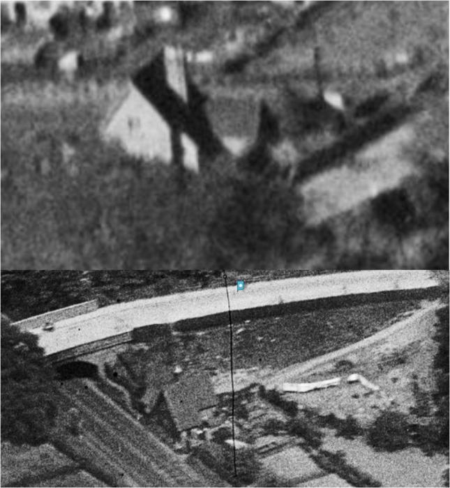
Sat 30th May 2026 5:49pm
There are several poor views but nothing really useful but two more aerial views here, looking from the south (above and to the left of the middle) and here from the north (bottom right).
I'll keep my eye open for something better but I wouldn't hold my breath. The images below are taken from Britain From Above, so not available as something official, just to identify if this is the building you're looking for.
|
| Public Transport and Travel - Radford Road station | |
|
PhiliPamInCoventry
Holbrooks |
4 of 30
Sat 30th May 2026 6:43pm
Hello,
Was it known as Daimler Halt or is that a different location. I'm sure that I've read about it & also a siding. I'm going to the Warwickshire railway website.
|
| Public Transport and Travel - Radford Road station | |
|
PhiliPamInCoventry
Holbrooks |
5 of 30
Sat 30th May 2026 7:09pm
Please look on the Warwickshire Railways Website, at the history of Daimler Halt.
Daimler Halt
|
| Public Transport and Travel - Radford Road station | |
|
Helen F
Warrington |
6 of 30
Sat 30th May 2026 7:23pm
|
| Public Transport and Travel - Radford Road station | |
|
PhiliPamInCoventry
Holbrooks |
7 of 30
Sat 30th May 2026 7:44pm
Hello,
Only conjecture, but the fire at the cotton mill might have more to do with what went on.
|
| Public Transport and Travel - Radford Road station | |
|
Helen F
Warrington |
8 of 30
Sat 30th May 2026 8:44pm
Which cotton mill? You've lost me.
|
| Public Transport and Travel - Radford Road station | |
|
Not Local
Bedworth |
9 of 30
Sat 30th May 2026 8:49pm
Demolition of the unused station in the 1970's does tie in with the extensive redevelopment and expansion of Barrs Hill School during that time. I recall that an unexploded German bomb was unearthed very close to the railway during this work. Had the bomb exploded as intended then this vital rail link would have been cut.
|
| Public Transport and Travel - Radford Road station | |
|
walrus
cheshire |
10 of 30
Sun 31st May 2026 7:59am
My guess is the station/halt might have been where Bridgeman Road curves near the railway line, adjacent to Radford Road. There is a modern house built in the space that might have been the station. I remember, as a child in the 50s, trains stopping at Daimler Halt a couple of times a day to service the Daimler and Coventry Climax, etc.
|
| Public Transport and Travel - Radford Road station | |
|
Annewiggy
Tamworth |
11 of 30
Sun 31st May 2026 8:26am
I am pretty sure that when I worked at the EMEB in Sandy Lane, where the timber yard is marked was used as a car park for the EMEB. Parking was very limited at the offices (now Park Place), the space behind the offices was a tennis court when I started in 1963 so the cars must have been parked down by the railway then. Eventually they also turned the tennis court into parking. You had to have a pass to park as space was very limited. I seem to remember that it did have access to the railway. I often used to walk across the footbridge to St Nicholas Street from the rec and I am sure there was evidence looking towards the Sandy Lane bridge of more than just the railway line, a long time ago though.
|
| Public Transport and Travel - Radford Road station | |
|
PhiliPamInCoventry
Holbrooks |
12 of 30
Sun 31st May 2026 8:59am
On 30th May 2026 8:44pm, Helen F said:
Which cotton mill? You've lost me.
It is not generally known that a short branch line ran from a point near the Coventry end of the station to the Coventry Cotton Mill which was situated next to the Coventry Canal and which opened in 1861. The Cotton Mill employed 400 people but was destroyed by fire in 1890, never to re-open. By 1896 the building was occupied by the Great Horseless Carriage Co and it was, in fact, the birthplace of the motor industry in Coventry. The branch was therefore known at various times as the Coventry Cotton Mill branch, the Widdrington Branch (the Rev. S H Widdrington, vicar of St. Michael's Church, was mainly responsible for financing the mill to provide work for people redundant from the declining ribbon trade), the Motor Mills branch and the Daimler Works branch, was in use and worked by the LNWR locomotives until the First World War. In fact the track was probably lifted shortly before Daimler Halt was built. The line crossed Sandy Lane by a level crossing. The crossing keeper's cottage still stands in Sandy Lane.
RW Kimber
|
| Public Transport and Travel - Radford Road station | |
|
Helen F
Warrington |
13 of 30
Sun 31st May 2026 9:23am
Ok, I see what you mean Phillip. On the 1888 map it's there as the Widdrington Mill (cotton) and by the 1906 map it is the Daimler Works but the branch line was still called Widdrington Siding. I'm not sure that the fire would have been the reason the Radford Station never opened. I think the decision had been made somewhat earlier.
|
| Public Transport and Travel - Radford Road station | |
|
PhiliPamInCoventry
Holbrooks |
14 of 30
Sun 31st May 2026 10:33am
Hello,
Whenever there is a fire or anything unplanned, changes are often chanced upon. Hence the offices where Anne prepared my EMEB bills might be a consequence.
|
| Public Transport and Travel - Radford Road station | |
|
Annewiggy
Tamworth |
15 of 30
Sun 31st May 2026 12:11pm
There is a picture of the building in the book Coventry up to Date which I think is dated about 1819. It also mentions the fire. I will post it later this afternoon when I get back from the hospital.
|
| Public Transport and Travel - Radford Road station | |

Website & counter by Rob Orland © 2026
