Helen F
Warrington
|
1 of 22
Thu 9th Jul 2026 7:19am
Text taken from Austin's Monthly magazine. The aim is to try to pinpoint the locations he discusses and illustrate them with maps and images. To comment, please quote which month you are discussing and/or a snippet of the text if relevant.  December 1934
Excavations revealed the depth of the Priory Pool. It is not known when the pool was made, but by what was revealed I should say about 13th century, or at least enlarged then. Its water was stored for the Prior's Mill, which stood where the three brick houses still stand in front of the office of Messrs. Newark's, timber merchants. At the rear still stands the old Mill House, converted into two cottages. Its original small windows are filled up with brick, also one gable end has been restored while the other is in its original state but hidden by other houses. The Mill was destroyed by the man who built the three brick houses in 1848. The Mill wheel stood at the north end of the Mill and the water race was discovered when making the new river bed. The wheel must have been an undershot one as the race was 14 feet 6 inches in depth. Around the race which carried the water, large sand stones had been placed for the purpose of keeping the mud and grit from entering. It is interesting to know that an assize was kept of the storage of water, for no mill further down the river could grind until the first mill released its water. If a miller kept too much water he was fined 6/8; half of which went towards the building of the city wall, and the other half to his Craft. At the time of floods the flood gates were to be opened under penalty of a fine of 20 shillings.
In 1430, one penny per strike was charged for the grinding of wheat or rye. No toll was to be taken, under penalty of a fine of 20 pence to the Mayor and 20 pence to the Bailiffs, Also, Millers were sworn twice a year to be true. They also had to join in the procession on Corpus Christi day, and for Watch on Midsummer even. In 1474, they were only allowed to have measures at the Mill that were sealed according to the King's standard.
At this time the leet ordered that they should have 1 quart of wheat for the grinding of one bushel, and another quart if he should fetch the corn to be ground; whilst only one pint for each purpose was allowed if grinding malt. They were not to water any man's corn to make it weigh heavier, nor to give inferior corn in place of good. In order, also, to help keep the miller honest, he was only allowed to keep 3 hens and 1 cock, under penalty of a fine of 40 pence. If, after being fined three times he still offended, he was put in the pillory. In 1541 a charge of 7d. per quarter only was allowed for grinding the baker's breadcorn, and he was forbidden to keep either pigs or ducks under penalty of a fine of 6/8. In 1544 it was ordered that the millers should be a fellowship and Craft of their own, but in 1551 it was ordered that they should hold no assembly, as in time past. In 1549 it was enacted that all bakers should have their corn ground by resident millers and not foreign millers, and that the charge be 8d. per quarter under penalty of a fine of 3/8.
Near the Fire Station wall the race that carried the water from the mill wheel and emptied into the stream was discovered. Also a mill wheel made of oak, 41/2 ins. in width and about 17 ins. in diam., having 8 peg holes, pegs still in part of holes, while in the centre of the wheel was a square hole for fitting onto the shaft; the pegs would fit into 8 corresponding holes in the large wheel. Lower down the river, about 30 yards beyond the Fire Station, the flood gates stood.
About 20 yards of the river bed was paved with stone. In the centre were large square shaped stones, and in them a groove cut about 4 ins. deep and 6 ins. wide for the gate to fit into for a stay against the floods. The gate was at least 17 feet long, and at each end a well was sunk and oak posts placed in for the wheels and chains necessary to raise or lower the gate as required. Two other mills stood between this gate and the Earl's mill in Cox Street. Altogether, from Spon End to Whitley mills were placed as often as possible.
December 1934
Excavations revealed the depth of the Priory Pool. It is not known when the pool was made, but by what was revealed I should say about 13th century, or at least enlarged then. Its water was stored for the Prior's Mill, which stood where the three brick houses still stand in front of the office of Messrs. Newark's, timber merchants. At the rear still stands the old Mill House, converted into two cottages. Its original small windows are filled up with brick, also one gable end has been restored while the other is in its original state but hidden by other houses. The Mill was destroyed by the man who built the three brick houses in 1848. The Mill wheel stood at the north end of the Mill and the water race was discovered when making the new river bed. The wheel must have been an undershot one as the race was 14 feet 6 inches in depth. Around the race which carried the water, large sand stones had been placed for the purpose of keeping the mud and grit from entering. It is interesting to know that an assize was kept of the storage of water, for no mill further down the river could grind until the first mill released its water. If a miller kept too much water he was fined 6/8; half of which went towards the building of the city wall, and the other half to his Craft. At the time of floods the flood gates were to be opened under penalty of a fine of 20 shillings.
In 1430, one penny per strike was charged for the grinding of wheat or rye. No toll was to be taken, under penalty of a fine of 20 pence to the Mayor and 20 pence to the Bailiffs, Also, Millers were sworn twice a year to be true. They also had to join in the procession on Corpus Christi day, and for Watch on Midsummer even. In 1474, they were only allowed to have measures at the Mill that were sealed according to the King's standard.
At this time the leet ordered that they should have 1 quart of wheat for the grinding of one bushel, and another quart if he should fetch the corn to be ground; whilst only one pint for each purpose was allowed if grinding malt. They were not to water any man's corn to make it weigh heavier, nor to give inferior corn in place of good. In order, also, to help keep the miller honest, he was only allowed to keep 3 hens and 1 cock, under penalty of a fine of 40 pence. If, after being fined three times he still offended, he was put in the pillory. In 1541 a charge of 7d. per quarter only was allowed for grinding the baker's breadcorn, and he was forbidden to keep either pigs or ducks under penalty of a fine of 6/8. In 1544 it was ordered that the millers should be a fellowship and Craft of their own, but in 1551 it was ordered that they should hold no assembly, as in time past. In 1549 it was enacted that all bakers should have their corn ground by resident millers and not foreign millers, and that the charge be 8d. per quarter under penalty of a fine of 3/8.
Near the Fire Station wall the race that carried the water from the mill wheel and emptied into the stream was discovered. Also a mill wheel made of oak, 41/2 ins. in width and about 17 ins. in diam., having 8 peg holes, pegs still in part of holes, while in the centre of the wheel was a square hole for fitting onto the shaft; the pegs would fit into 8 corresponding holes in the large wheel. Lower down the river, about 30 yards beyond the Fire Station, the flood gates stood.
About 20 yards of the river bed was paved with stone. In the centre were large square shaped stones, and in them a groove cut about 4 ins. deep and 6 ins. wide for the gate to fit into for a stay against the floods. The gate was at least 17 feet long, and at each end a well was sunk and oak posts placed in for the wheels and chains necessary to raise or lower the gate as required. Two other mills stood between this gate and the Earl's mill in Cox Street. Altogether, from Spon End to Whitley mills were placed as often as possible. |
|
J. B. Shelton's Archaeology -
Shelton - Priory Pool, Mills & Tower
|
Helen F
Warrington
Thread starter
|
2 of 22
Thu 9th Jul 2026 7:26am
February 1935
At the Hales Street entrance from New Buildings the foundations of a City Tower was discovered at a depth of about 12 feet. This tower was actually in the river bed at a short distance from the flood gates. As I expected, the city wall was also discovered at this point, but the tower had not been known. On searching the Leet book, however, I found it mentioned in 1457 as Priory Tower.
The city wall in its original form was less than 3 miles in circumference, but in 1462 to 1480 it was enlarged, each important dwelling being surrounded, viz; The White Friars, The Grey Friars, St. John's Church, and Benedictine Monastery. It is the Benedictine Monastery of which I want to speak. The wall was built round its northern borders about 1403, during the mayorship of John Smythier. From Cook Street Gate it came to the corner of the new part of the Fire Station (please note the Priory Tower or Swanswell Tower of to-day was not built until the other tower was pulled down) then running in front of the Station to the river where the Priory Tower then stood. From there the wall ran to the east, and quite a large portion is still under Messrs. Newark's, the timber merchants while another part is still in the ground running to the south up New Buildings. This part may have been a lean-to wall staying the tower, or otherwise made for holding back some of the water of Priory Pool.
The rest of this article is history.
|
|
J. B. Shelton's Archaeology -
Shelton - Priory Pool, Mills & Tower
|
Helen F
Warrington
Thread starter
|
3 of 22
Thu 9th Jul 2026 7:27am
March 1935
The complaints of the Prior were many, and besides the complaints mentioned in the article last month, he said that they broke open the gates at Spittlemore letting out his cattle, and made it a general sporting place, and when rebuked, they gave the Prior and his servants short language, saying that they would keep it as a sporting place. Fishing in the Swanswell was another complaint, as they took the fish by stealth, and thus caused great loss to the Church. They also washed in the pool, the Prior suggesting that it hurt the fish, but the citizens replied that it would help to fatten the fish.
Cook Street Gate came under the list of complaints, the Prior saying that the people placed a quantity of builders' rubble on the dung heaps, which the farmers carted away to their land, but refused to do so because of the rubble; also the gateway was blocked up, so that the Prior could not get through to his orchards (which would be near what is now Jesson Street).
The plumb house, where the lead was hammered out for roofs and windows, was claimed by the Prior, while the Church of St. Michael claimed it also, and possibly rightly so, because it stood in front of the Drapers' Hall, near Bayley Lane.
Regarding the story of the City Wall, the Prior stated that they had paid £10 per annum murage to the City Wall, and that the Corporation should have built 6 perches per year, whereas they had only built 2 perches, and that most of this money had gone to the repair of the wall on other land. The leet replied that they considered the people of the Monastery should be thankful, as the pulling down of the old wall, and including St. Osburg's pool (now the Pool Meadow) cost them 5 marks more than the first wall, and as the wall protected their Monastery grounds, and also that no other complaints had been made prior to that of Prior Shotswell in 1461-2.
The newly discovered Tower base would appear to be about the same size as the present Priory or Swanswell Tower. The river bed where it was discovered would at one time be a part of a pool of very large extent, and the ground to a great depth was of very marshy quality. To build a large stone building or gate would be impossible without a strong foundation, and to make such a foundation it required timber of great thickness.
|
|
J. B. Shelton's Archaeology -
Shelton - Priory Pool, Mills & Tower
|
Helen F
Warrington
Thread starter
|
4 of 22
Thu 9th Jul 2026 7:29am
April 1935
The timber was from large elm trees, with all branches trimmed off, and the trunks made into square beams, about 2-ft. 3-in. in width. The task of getting them in position must have been a clever feat in those days, for the marsh near the river was very deep and difficult. It must have required a lot of horse power as well as man power; quite a dozen horse shoes were found which had been pulled off in their struggling, some of these nearly new.
As digging proceeded, the timbers were uncovered, and found to form a massive foundation, smaller branches being morticed in the larger; the men found it very difficult to remove them, for as all the ground was not required they had to be cut off with axe and stubbing tools. Some of these timbers are under the causeway and roadway now. Two pieces cut off would weigh at least one ton each, and pulleys were fixed to lift them out - these timbers are now preserved.
At the time of building this tower at least three feet depth of water would have to be dealt with; no wonder that a number of shoe soles came from here, as well as the horse shoes. As the Priory Mill dam extended to the Tower, no horse road would be made through it, but boats were used on the pool, and in these the Prior and Convent would reach the tower. Three boat-hooks have been discovered during excavations The workmen evidently lost a lot of tools in those days, and as so much mud and water was there, if a tool was dropped it was difficult to find it - and numerous were the tools discovered.
Three tiers of stones with a plinth were found in position on the timbers, and at the side of the plinth the mason, or labourer, had placed his pick, and the rising water had covered it. The iron is of a fibrous nature, tough and sharp at one end, with a flat hammer like a collier's pick of to-day, at the other end. The shaft is of ash, and although one half is split from top to bottom into small pieces, the other half is quite good and tough, and could even be used on light work to-day. Quite a number of bill-hooks were found, some in good condition, but no wood handles on. These are of very similar shape as of to-day. Scores of iron pins with heads and a hole for a small pin at the other end were found. These would be for shutter pins, and were made the same as shutter pins of to-day. Large and small nails were in abundance.
|
|
J. B. Shelton's Archaeology -
Shelton - Priory Pool, Mills & Tower
|
Helen F
Warrington
Thread starter
|
5 of 22
Thu 9th Jul 2026 7:31am
May 1935
One piece of wood which was found was so straight that it was probably a level. Many hammers were brought to light, one with claws like a blacksmith's hammer, and with the shaft complete, made of ash, which could be even now of serviceable use. Blacksmiths' punches, horses' bits, harness buckles, spurs, stirrups, a large brass bowl pinched at the rim with pliers, a "bleeding" bowl of pewter and small razor complete, a number of knives with maker's marks, pewter spoons, and other articles too numerous to mention. Under the floor of the tower, which was of stone, and about nine inches thick, was a spoke-shave, and the small hammer which would be used in tapping the knife in or out as required - it is very crude, having an oak frame, with an iron knife. I should be glad to know if any other similar has been discovered of this age or period.
This article continued with history of other gates and isn't relevant to this dig.
|
|
J. B. Shelton's Archaeology -
Shelton - Priory Pool, Mills & Tower
|
Helen F
Warrington
Thread starter
|
6 of 22
Thu 9th Jul 2026 8:25am
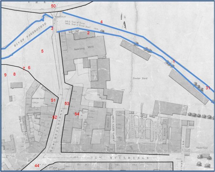
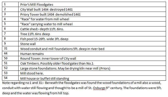
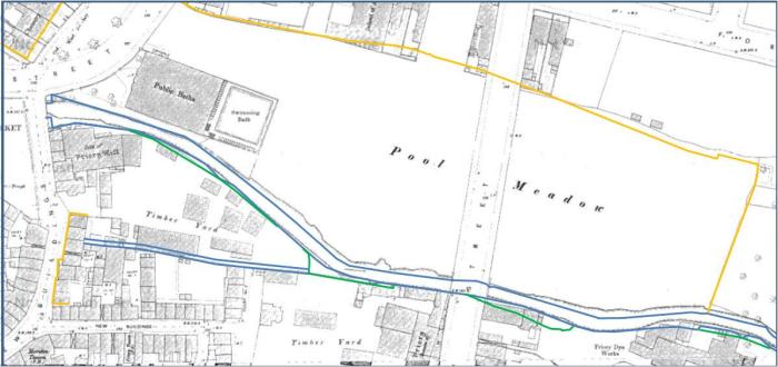
I'll start by mapping the area under discussion. The first map is based on the relevant section of the Trinity Street dig recorded in A Harvest of History - The life & work of J B Shelton MBE. I've used the Board of Health map because it shows some features that Shelton may have been observing decades after they were demolished, rather than centuries. To compare I've included a similar map with more contrast and some reference points of note. That map may be subject to additions as I or anyone else needs to discuss features other than the first I've identified.
 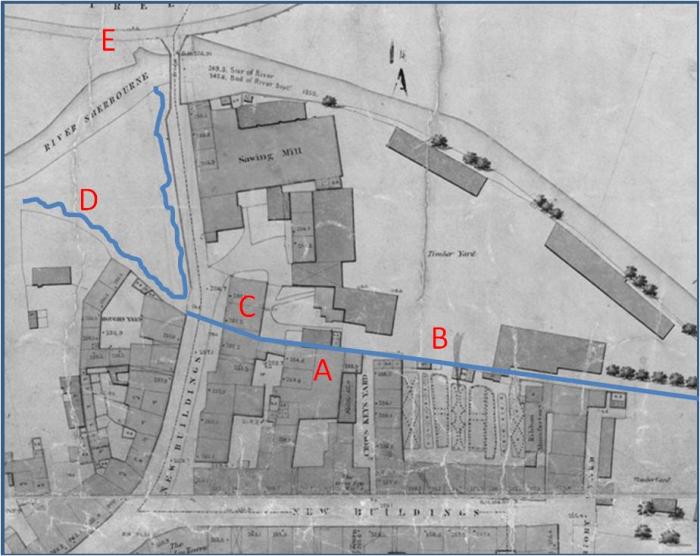
A - next to the early mill.
B - the millrace.
C - 'new' housing even in 1850 but site of early mill.
D - the pool had a hard edge but within that there was an irregular embankment with bushes etc.
E - the Radford Brook and stream from St Agnes well came in from this direction but had been rerouted by 1850.
 |
|
J. B. Shelton's Archaeology -
Shelton - Priory Pool, Mills & Tower
|
Helen F
Warrington
Thread starter
|
7 of 22
Thu 9th Jul 2026 11:47am
The following is probably one of the most iconic views of the city, showing the priory pond. There are multiple versions of it and it's very hard to work out how many are original and how many are copies. By the time the BoH map was drawn, the pond had not only been drained but it had been totally filled in, bringing the ground up to the level of New Buildings (seriously, that's a dumb name and I much prefer Priory Lane as on the 1749 map). By Shelton's time the road had been widened and the whole pond and river area had been covered over and had become the Smithfield Market, which would have added extra inches over what had been the ground level in 1850.
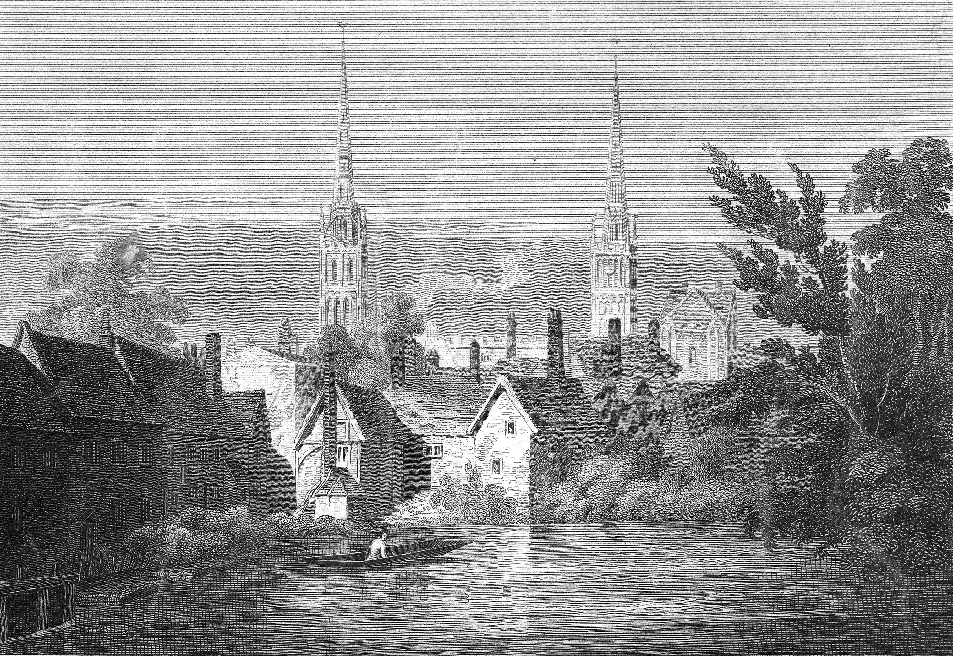
The two buildings directly on the left are 'new' and don't appear on the 1749 map. While the (not in image) saw mill behind them is marked on later Ordinance Survey maps as the site of the Prior's Mill, I've no idea why and certainly it wasn't marked as such on the BoH map. Since the mill and the buildings weren't removed during Shelton's time, thus precluding any dig underneath, I'm not sure how anyone made that conclusion. Perhaps there are clues in his writings?
His opening line on December 1934 was " Excavations revealed the depth of the Priory Pool." Which is a bit annoying because he doesn't seem to mention it. However the BoH mappers kindly included the height above datum of the river bed as 247.6 feet. What we don't know is if they returned the course of the river to its original channel or chose a new route but the BoH map measurement was after the dam, so give or take silting, was roughly the level of the deepest part of the pond (the original channel). While it was essential that the roadway and buildings were higher than the level of the pond, the views of the pond show that there was a raised embankment round the edges, so the difference between the water surface and the walkways might have been minimal. The lowest level at 1850 was the end of the road from St Agnes Lane at 255.7 feet. That's a difference of 8.1 feet. Even if the level was kept below the roads and it became shallower at the edges, there would have been plenty of keel room for flat bottomed boats. While there would be a natural rise in the river bottom as you headed upstream of both the Sherbourne and the Radford Brook, I wonder how far up they would have been suitable for a small punt, like the one in the picture  |
|
J. B. Shelton's Archaeology -
Shelton - Priory Pool, Mills & Tower
|
Helen F
Warrington
Thread starter
|
8 of 22
Fri 10th Jul 2026 4:54pm
December 1934
"Its water was stored for the Prior's Mill, which stood where the three brick houses still stand in front of the office of Messrs. Newark's, timber merchants."
A confusing use of 'the office' because there were three houses in front of the Newark site at the bottom of New Buildings as shown below and one of them was listed as their office but he means the whole site that extended over most of the land from the river to the millrace. The exception was part of a short row of three terraced properties which he is referring to. The location is marked 53 on the map.
The mill on the roadside can be seen in the old sketches of the pond. I've chosen this one because it's particularly informative.
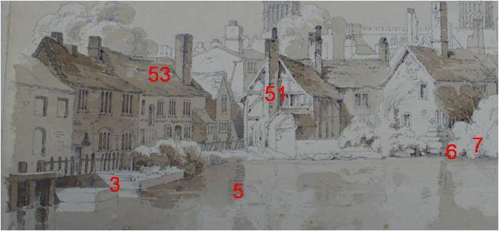
December 1934
"At the rear still stands the old Mill House, converted into two cottages. Its original small windows are filled up with brick, also one gable end has been restored while the other is in its original state but hidden by other houses. The Mill was destroyed by the man who built the three brick houses in 1848. The Mill wheel stood at the north end of the Mill"
The Trinity Street dig map shows 53. 54 - Mill house or buffet, is slightly off position because it was just off the map they were using in the Sheldon book. "The Mill wheel stood at the north end of the Mill" must refer to the very old building because the millrace would have been in the middle of the building at the front. Anne kindly posted an image of the very old mill. The mill wheel would have been at this end.
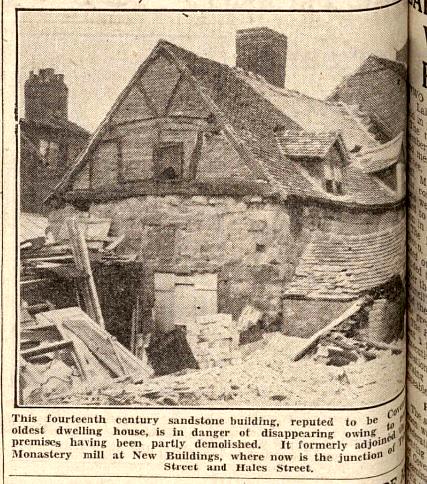
It actually survived the war and can be seen in this image at Britain From Above. Left hand side, halfway up.
The age of the mill building on the road is problematic. It's a brick front, probably from the 1700s but older timber buildings were sometimes boxed in, to give them a smarter appearance; and/or make them more durable (but had the opposite effect); and/or to remove an overhanging upper storey. It's a very small building height wise. When the three new homes were built, they didn't replace all of the mill building and the most southerly part remained as you can see below in the photo posted by Cliff B. Note the style of the two (the one on the left is very distinctive of the Coventry period 1830-1850). Observe the height differences. The older building looks very low on the road and that would be evidence of laying a new road surface over the old one. This would have caused significant damp problems. The issue might also point to the original road height being close to that of the pond surface as this cottage was on a slope in two directions. It had no front door as the original had been in the rest of the demolished building so its door was actually in the passageway of the new terrace (arched opening), almost 2ft lower than the original roadway and lower still after the road was resurfaced. The rear courtyard was even lower at 3.6 ft lower than the road.
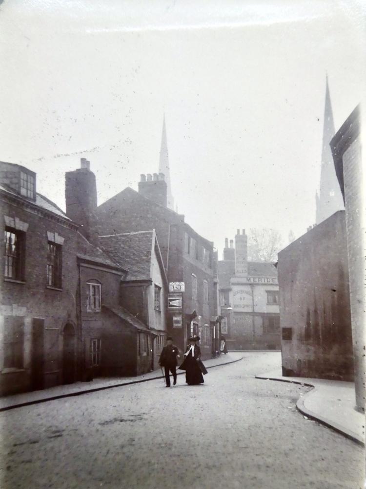 |
|
J. B. Shelton's Archaeology -
Shelton - Priory Pool, Mills & Tower
|
Helen F
Warrington
Thread starter
|
9 of 22
Sat 11th Jul 2026 9:50am
December 1934
"The Mill wheel stood at the north end of the Mill and the water race was discovered when making the new river bed. The wheel must have been an undershot one as the race was 14 feet 6 inches in depth. Around the race which carried the water, large sand stones had been placed for the purpose of keeping the mud and grit from entering."
This is above my pay grade. If the pond was 8.1ft deep, was his discovery number 5 on the map as an inlet for the mills at 54 and 53? Or did he know it from excavating it on the other side of the mill? If the former, then it would be the deepest part of the pond, substantially deeper than the riverbed. He finds a lot of millraces in the pond area, not to mention some flood gates that aren't where I thought they'd be. It may be because there has been more than one mill location or that he was seeing something other than mill infrastructure. He talks about the 'new river bed' and I'm assuming he means the new culvert under Smithfield Market but that was cut before 1888 and Shelton didn't get involved in the archaeology until 1927. He wasn't even born until 1896. So 5 must have been observed in conjunction with the culvert but not when it was excavated and/or he was using records created decades earlier by someone else. The new channel could have done all sorts of damage to the underlying archaeology. I'll come back to this issue when I discuss the Priory Tower because I think that there was something else going on.
At this point it might be important to note that Shelton's archaeology was not the same as today. He didn't do or command the digging, he just operated around the men preparing the land for the new roads and buildings. He may have got a few bits of extra feet of earth dug to chase a discovery but I doubt that they dug holes solely to see if there was anything hidden. I also think that if they dug up something interesting and he wasn't there, it didn't get recorded.
|
|
J. B. Shelton's Archaeology -
Shelton - Priory Pool, Mills & Tower
|
Helen F
Warrington
Thread starter
|
10 of 22
Sun 12th Jul 2026 11:42am
One of the things to consider when examining the waterways of Coventry at the point the mills were removed, is that Coventry had been very man made from its earliest form and the rivers and streams as much as anything else. Coventry is somewhat flat. No, stop laughing, it is. We know that it is because of its slow moving river. Looking at the Sherbourne and the streams around, they show a great many meanders. A quick look at the 1749 Bradford Map, shows this feature in the river while it parallels Spon Street. The river exiting the city and running south to Whitley was the same on the oldest maps. Even by 1850 some of those meanders had been removed and the river is considerably straighter than it was naturally. It's why Swift's Corner Mill was nowhere near the water after they built the railway, although initially they had made provision for there to be a channel under the embankment.
Then examine the river through the city centre. While there were some curves, the whole thing is suspiciously straight, especially at Pool Meadow (more on that later). Two of the known mills were part of a loop, with the millrace stemming from the base of a loop. It was not uncommon for the millrace to become the main river channel once the mill was removed (by man or sometimes by nature) in order to speed the water away and to free up building land. Cutting a channel at the base of a meander gives control over the quantity of water passing through the mill.
To understand the concept, a good guide is this episode of Time Team on the mill at Dotton in Devon. Note that there was no dam but there was a weir set well before the mill.
Time Team
Note how the wheel was described as a big one at a diameter of 3m = 9.8ft. Ok, that one was Victorian but was clearly sufficient for a simple mill. While the centre of the wheel was a bit below the ground level, it wasn't far below. The older wheel pits were slightly deeper but not massively so. Both the base of the millrace (leet) and wheel pits had been raised over time and the land had probably risen with it (as evidenced by the depth they had to dig to get down to the mill and the millrace in the first place).
December 1934
"The wheel must have been an undershot one as the race was 14 feet 6 inches in depth."
14ft 6 inches from the water level before the dam was built; or from the water level the old mill was at; or from the ground level in Shelton's day? It might matter. The more modern mill on New Buildings was only 7.9ft higher than the river surface in 1850. The wheel doesn't sit even halfway under water, so I struggle to see a land/water situation that would need a channel that deep to supply a wheel of logical design and proportions. Or might it be something else?
|
|
J. B. Shelton's Archaeology -
Shelton - Priory Pool, Mills & Tower
|
Helen F
Warrington
Thread starter
|
11 of 22
Mon 13th Jul 2026 9:15am
At the priory pond, and other places in the city, they went further than just taking a millrace off the river, they built a dam crossing from New Buildings to St Agnes Lane, a natural pinch point in the landscape. That meant they could store water from the river. At this moment it's where the BoH map comes into its own.
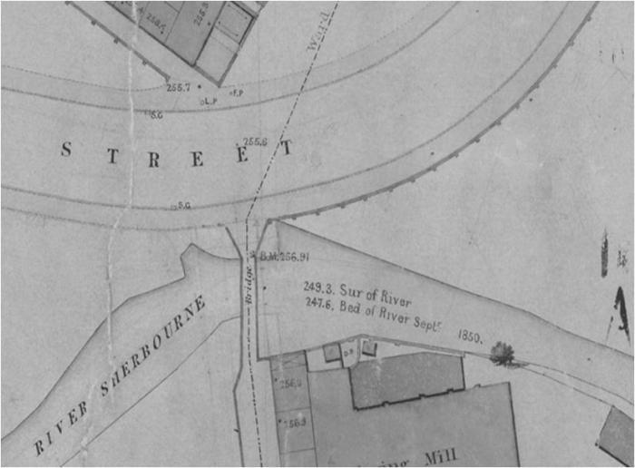
You can see where some of the working parts of the dam were. There are some suspiciously man made features. This isn't the millrace, it's the sluices or flood gates as Shelton calls them. This is where the gates could be opened if there was too much water or if the pond needed draining eg for maintenance (after first closing the gates up river at Spon and Naul's Mill and possibly Ram Bridge). Until industrial pollution this would have been good for growing crops and supplying river pebbles for roads. I don't know if they did this but it would make sense. It's how the land could rise at the same time as the river would silt up.
This area is at number 3 on the excavation map and on this view of the pond. It extends further to the left. Note the very angular shaped structures. Were they just part of the dam?
A bit cheeky of me but I'm going to include part of a Troughton sketch of the priory pool area after they'd filled in the pond.
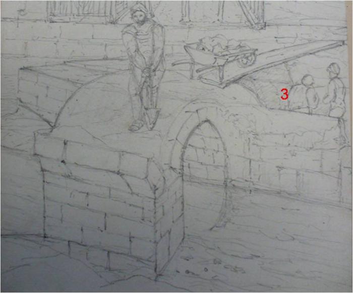
This is no modern, brick installation, it's the demolition of large, worked stonework. Are the remains of this what Shelton found?
A final thought. Was what you see in the BoH Map all there was of the dam? I wonder if they only kept part of the structure because there was only the small Sherbourne left to deal with and they needed the space for Hales Street. I think that I can see the remains of at least three arches in the sketch. On the 1749 map it looks like the sluices structure was about half as long as the edge of the pond against New Buildings.
|
|
J. B. Shelton's Archaeology -
Shelton - Priory Pool, Mills & Tower
|
Helen F
Warrington
Thread starter
|
12 of 22
Mon 13th Jul 2026 10:11am
An additional thought about 'new river bed' after looking at the image below. There is a curve in the soil crossing from Palmer Lane to New Buildings, so possibly they cut yet another channel for the river? Probably they feared that the old culvert wasn't strong enough for the new construction, or wouldn't last long enough. That might explain the brick work arch found in the recent excavation done to open up the river area at Palmer Lane. Does it date to the late 1800s or was it a remainder of the bridge already over the river at Palmer Lane?
If this is the case, did Shelton discover the work done in the early 1800s to remove the pond and create a new channel for the river?
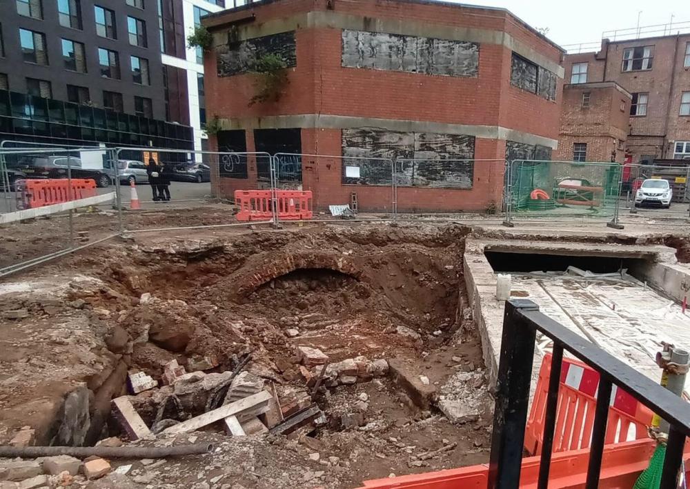
Ah, I've found confirmation. I'm now fairly sure that 5 on the map isn't a millrace but the post pond river channel.
|
|
J. B. Shelton's Archaeology -
Shelton - Priory Pool, Mills & Tower
|
Mike59
Coventry
|
13 of 22
Mon 13th Jul 2026 7:09pm
Fascinating reading complete with interesting photos to help picture things.
I recall that episode of Time Team, a very interesting archaeology series on a Sunday evening, often sitting with my son who also found it interesting.
John 'Geophys' Gater and his probe for testing the ground before digging any trenches.
John Gater and his probe analysis of the ground certainly encouraged me to look at open ground differently, with a view to what archaeology that area might present if explored, properly.
Phil Harding still does some presenting, and sadly Prof Mick Aston, with his colourful scarves and hats, is no longer with us.
Mike "Yesterday I was a child of the sixties…. Today I’m a cynical adult…"
|
|
J. B. Shelton's Archaeology -
Shelton - Priory Pool, Mills & Tower
|
Helen F
Warrington
Thread starter
|
14 of 22
Tue 14th Jul 2026 7:30am
Thanks Mike, I'm glad you're enjoying this 
Are there any of us who weren't drawn to archaeology because of Time Team?  I always felt that John should have been allowed a day's start on the others, because they often couldn't do their best digging until they'd got some of the geophys. Time Team demonstrated the value of the technology. Stewart Ainsworth was another of my favourites and often proved that maps are invaluable. His was the role that appealed to me most, although I wish I could bring it altogether like Victor Ambrus and his sketches (also, sadly no longer with us). The BBC's Digging for Britain isn't quite the same and while the digs are professional and take longer, the shows includes too many different digs per episode. Phil Harding turns up on that every now and then. Raksha Dave periodically does history specials on C5.
I'm only a day ahead of you all, as I'm putting this together as I go along. I'm finding possible answers when I go looking for things to illustrate the articles eg the map I added of the culverts to my last comment. Ben at Coventry Digital has added a lot of images that I've not seen before but finding them is still more of an art than a science. |
|
J. B. Shelton's Archaeology -
Shelton - Priory Pool, Mills & Tower
|
Helen F
Warrington
Thread starter
|
15 of 22
Tue 14th Jul 2026 8:11am
December 1934
"Near the Fire Station wall the race that carried the water from the mill wheel and emptied into the stream was discovered. Also a mill wheel made of oak, 41/2 ins. in width and about 17 ins. in diam., having 8 peg holes, pegs still in part of holes, while in the centre of the wheel was a square hole for fitting onto the shaft; the pegs would fit into 8 corresponding holes in the large wheel. "
This describes number 4 on the dig map. It's another of those 'how many mills are we talking about?' issues. It could be an older mill, before the priory pond was created, but I'm wondering if it was the outflow wall from the dam. Especially if the dam was originally wider than shown on the BoH map. I'll go into more depth when I get onto the next articles. The discovery of the mill wheel is irrelevant in terms of location. It could have been discarded anywhere along the water system or just chucked in the hole before they filled it in. This is why modern archaeology is so tedious painstaking. It requires forensic accuracy to date, not just the object but if its location is contemporary with its use. Time Team has an episode on that too.
The final discoveries mentioned in the December article were found directly in the river and must be related to the work culverting the river to make way for a car park connected to Pool Meadow bus station. We have a picture of that posted originally by Prof.
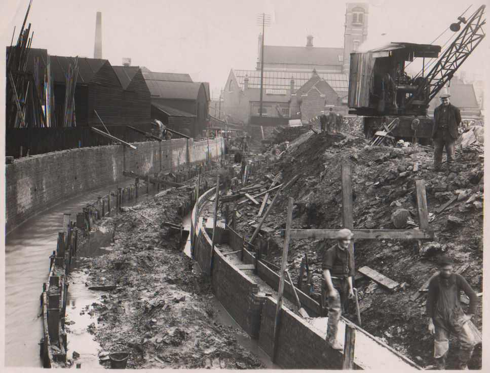
Look how deep they were in relation to the land to the right but how much of that is due to excavating the foundations for the culvert and how much is natural? This painting shows roughly the same area as the foreground in the photo and there wasn't the dramatic embankment.
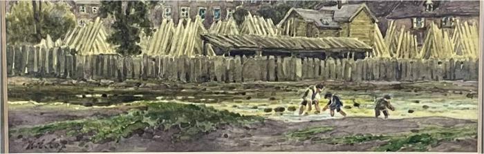
To the right of the photo stood Pool Meadow. In 1888 it was still largely empty except for Priory Street and the city's second baths had been erected (pictured below from 1865) on Hales Street, where the fire station would be built. What was alarming was the rate at which the northern edge of the river was being eroded and the southern edge was seeing deposition. The subsequent maps show more erosion but I'll cover that when I get onto Pool Meadow. Meandering river in action!
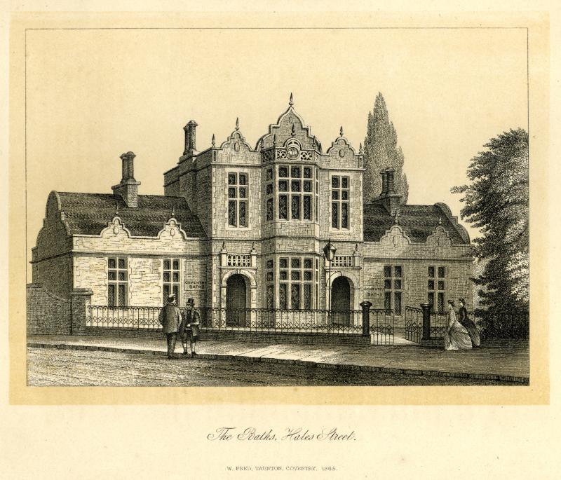
By 1906, they'd demolished the baths and rebuilt them to the east of Priory Street (pictured below), built the fire station and built a Hippodome to the west of Priory Street. Not sure if there is a picture of that and if there is, would we recognise it?
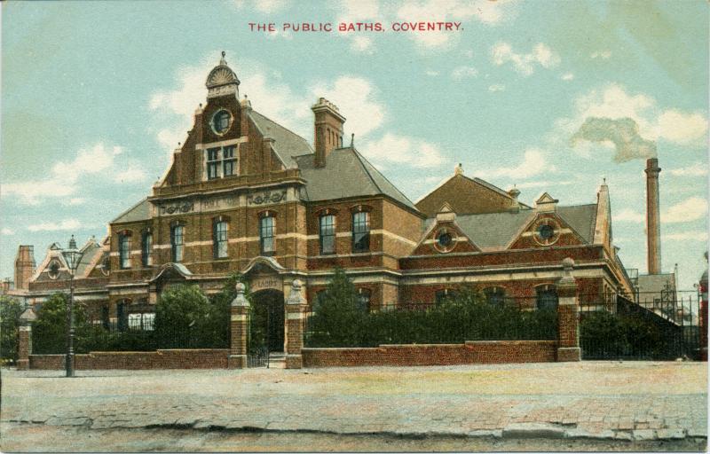
By 1926, they'd demolished the Hippodrome, added a mortuary to the rear of the fire station and added sloped reinforcing to the ever eroding north side of the river. All those foundations dug, all that demolition and you can imagine that all the debris wasn't removed from site, it was distributed, rapidly raising the height of the land to the north side of the river. From that area alone, we have to be careful about recorded depths of finds. We can't draw a time line of gradual deposition.
So you can imagine that if the river was eroding so much of the Pool Meadow shoreline from 1888 to 1926, it had been doing the same from 1850 to 1888. Any walls would have been continually undermined and then had to be rebuilt. To try and stabilise it, they'd have dug some pretty deep foundations. While the same erosion would not have been as bad while the mill ponds and mills were there, the problem would have existed before the dam was built and adds another clue to what might have gone on in Pool Meadow before those fish ponds existed, never mind were enclosed by the city wall.
To return to the photo of the work on the river. So far they'd shuttered the river, partway into the normal flow and built a new boundary to the south. I'm guessing that they then shifted the flow of the water to the other side of the shuttering and build the second wall? Finally removing the shuttering and capping the river. That's how Shelton was able to inspect the ancient riverbed
|
|
J. B. Shelton's Archaeology -
Shelton - Priory Pool, Mills & Tower
|