
|
brummiebelle
Devon |
1 of 80
Wed 27th Jun 2012 11:38pm
Hello forum members, this is my first post so please excuse me if I have put it in the wrong section. My 4xgreat grandfather William Williamson was living in Hill Street in 1841 at the time of his second and third marriages and I have found a family with the same surname in the area. Please can anyone tell me what was the area like at this time, was it a poor area or a grand one. Are there any images of Hill Street around this time and is there much left standing so would it be worth a visit.
Also his wife was blind, I have discovered, from childhood. Were there any schools for the blind at this time. I have heard that some children went blind though work on watches in the area, is it possible this could have happened to her. Many thanks, Maria
|
| Streets and Roads - Hill Street | |
|
TonyS
Coventry |
2 of 80
Thu 28th Jun 2012 7:33am
Hi brummiebelle, and welcome to the forum!
 Sadly there is very little in the way of housing left in Hill Street today (although a few 'cottage type' properties still remain)
Do you have a house number for your 4x great GR andfather? Then we should be able to pin-point the location.
My great grandmother also lived in Hill Street for a time, but a little later than your relative. A few years ago (prior to part of it being dug up for building) they had an archaeological dig, which was quite interesting. I have a number of photos that I took at this time - as well as one Hill Street in the late 1800's.
Here's a link to my pics of the Hill Street dig (sorry they are quite small). The hoarding you can see in the last few photos runs down the length of Hill St.
Sadly there is very little in the way of housing left in Hill Street today (although a few 'cottage type' properties still remain)
Do you have a house number for your 4x great GR andfather? Then we should be able to pin-point the location.
My great grandmother also lived in Hill Street for a time, but a little later than your relative. A few years ago (prior to part of it being dug up for building) they had an archaeological dig, which was quite interesting. I have a number of photos that I took at this time - as well as one Hill Street in the late 1800's.
Here's a link to my pics of the Hill Street dig (sorry they are quite small). The hoarding you can see in the last few photos runs down the length of Hill St. 
|
| Streets and Roads - Hill Street | |
|
Midland Red
|
3 of 80
Thu 28th Jun 2012 8:41am
Hello and welcome to the forum
If I read the 1841 census correctly, your ancestors actually lived at Hill Street Place - I'm not familiar with that address so I can't say whereabouts on Hill Street it was
If I have the right family, the remaining members had moved into Gas Street by the 1851 census
There are many William Williamsons in and around that area - I know because I'm descended from a couple of them myself - they lived in the Spon Street area
Hopefully, someone will identify just where Hill Street Place was for you
Good luck
|
| Streets and Roads - Hill Street | |
|
dutchman
Spon End |
4 of 80
Thu 28th Jun 2012 2:00pm
Hello Maria, and welcome to Rob's forum
On 27th Jun 2012 11:38pm, brummiebelle said:
Hello forum members, this is my first post so please excuse me if I have put it in the wrong section. My 4xgreat grandfather William Williamson was living in Hill Street in 1841 at the time of his second and third mariages and I have found family with the same surname in the area. Please can anyone tell me what was the area like at this time, was it a poor area or a grand one.
The area was generally poor with a high concentration of Irish immigrants. There were a handful of managers houses at the very top of the street but those were the exception. The majority lived in weavers cottages of which only a few have been preserved. The area specialised in Worsted Tweed unlike the silk-weavers elsewhere in Coventry.
On 27th Jun 2012 11:38pm, brummiebelle said:
Also his wife was blind, I have discovered, from childhood. Were there any schools for the blind at this time. I have heard that some children went blind though work on watches in the area is it possible this could have happened to her.
Quite possible. If this was the case then the only school she attended would be the one in the Workhouse. The children from the workhouse were rented-out to local watchmakers and often went blind by the age of twelve. Few children over the age of twelve went to a school of any kind. |
| Streets and Roads - Hill Street | |
|
charabanc
Coventry |
5 of 80
Fri 29th Jun 2012 6:26pm
To answer one of your questions, there are still two buildings at the bottom of Hill Street of historic interest, the original Bablake School (c 1560) and Bonds Hospital (1506), the latter originally providing almshouses for the poor.They share a courtyard and are, effectively, on the same site.These are very photogenic and are depicted elsewhere on this website.The street has been cut in two by the city's ring road since the 1960's but at the top end is the Roman Catholic Church of St Osburg's (dedicated to St Osburga) which was opened in 1852 and so would have been contemporary with your ancestors. Round the corner at the bottom is St John's Church in Fleet Street, once known as Bablake Church (but with old spelling). All are worth a visit. St John's was used to contain royalist prisoners during the English Civil War.
|
| Streets and Roads - Hill Street | |
|
tenpasteight
Croydon |
6 of 80
Mon 14th Apr 2014 6:00pm
Does anyone know of Hill Street cemetery, possibly in Coventry. These items (from a bible) refer.
Richard Hands, the father of John Hands died 14th April, 1803, and was interred in Hill St. Cemetery. Aged 66.
Elizabeth Hands, mother of John Hands, died 13th March, 1817, and was interred in the Dissenters burying ground in Coventry.
Roderick Fullilove
|
| Streets and Roads - Hill Street | |
|
flapdoodle
Coventry |
7 of 80
Tue 15th Apr 2014 8:13am
Was St Osburg's damaged in the blitz?
|
| Streets and Roads - Hill Street | |
|
charabanc
Coventry |
8 of 80
Tue 15th Apr 2014 10:52am
If you Google 'St Osburgs' the fifth site down (the Coventry and Warwickshire website) gives an account of the damage to the church during the November 14th / 15th raid on the city.
|
| Streets and Roads - Hill Street | |
|
dutchman
Spon End |
9 of 80
Tue 15th Apr 2014 7:46pm
On 14th Apr 2014 6:00pm, tenpasteight said:
Does anyone know of Hill Street cemetery, possibly in Coventry. These items (from a bible) refer.
Richard Hands, the father of John Hands died 14th April, 1803, and was interred in Hill St. Cemetery. Aged 66.
Elizabeth Hands, mother of John Hands, died 13th March, 1817, and was interred in the Dissenters burying ground in Coventry.
Er... yes:
Dissenters burying ground, Coventry
|
| Streets and Roads - Hill Street | |
|
nevis42
bedworth |
10 of 80
Sun 20th Apr 2014 2:48pm
So glad I found this site
 . Does anyone have a photograph of the cottages which once stood in Hill Street? Recently discovered my ggrandfather once lived in one (my mum recalls it being white?). But it's no longer there. Also trying to locate a grave plot number 160 located at London Road cemetery but no idea how or where to find it. Appreciate advice or information please. Many thanks. . Does anyone have a photograph of the cottages which once stood in Hill Street? Recently discovered my ggrandfather once lived in one (my mum recalls it being white?). But it's no longer there. Also trying to locate a grave plot number 160 located at London Road cemetery but no idea how or where to find it. Appreciate advice or information please. Many thanks.  sue
|
| Streets and Roads - Hill Street | |
|
dutchman
Spon End |
11 of 80
Sun 20th Apr 2014 4:52pm
Hello Sue
Some of the cottages survive and are pretty much unchanged:
LINK |
| Streets and Roads - Hill Street | |
|
TonyS
Coventry |
12 of 80
Sun 20th Apr 2014 5:28pm
Hi nevis42, and welcome to our forum
 London Road Cemetery is divided into Squares and then into Grave numbers, did you mean "Square number 160"? If so, I've indicated it's approx position on the map below.
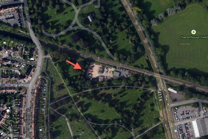 Image ©Google Maps
 |
| Streets and Roads - Hill Street | |
|
Garlands Joke Shop
Coventry |
13 of 80
Sun 20th Apr 2014 5:36pm
Hi Nevis42,
was looking at my version of the map and can see rough location of plot 160 (highlighted yellow)
(I think TonyS is spot on
)
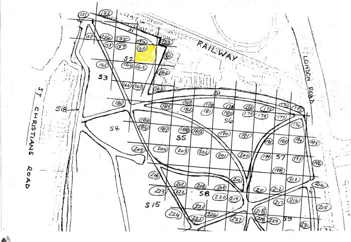 If the grave your looking for has a headstone it should be plain sailing- if not you might need to go to the cemetery office at Canley crematorium with the date of death & name (there may be a small charge) or better still the grave's grid reference (think you can find that in the burial records in the Herbert art gallery history centre).
Luke.
If the grave your looking for has a headstone it should be plain sailing- if not you might need to go to the cemetery office at Canley crematorium with the date of death & name (there may be a small charge) or better still the grave's grid reference (think you can find that in the burial records in the Herbert art gallery history centre).
Luke. |
| Streets and Roads - Hill Street | |
|
Annewiggy
Tamworth |
14 of 80
Sun 20th Apr 2014 6:13pm
My grandad and his 2 wives (not at the same time) are in 179, I still have the certificate with the details on.There should be white markers on the corners of the squares but they are a bit difficult to find.
|
| Streets and Roads - Hill Street | |
| TonyS |
15 of 80
Sun 20th Apr 2014 6:20pm
|

Website & counter by Rob Orland © 2026
