 . Even if the newer photo had been placed to see round the New Inn, the factory had been demolished by then.
|
Helen F
Warrington |
91 of 263
Wed 9th Sep 2015 2:32pm
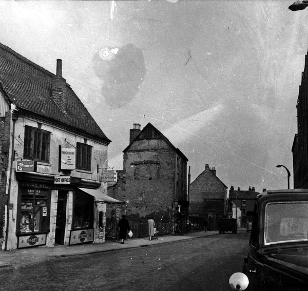
Anne, the two photos are looking in the same direction but the newer picture is more west than the other. There were two places where the road narrowed. The first is at the New Inn, the decrepit building to the left of the old photo. The corner is just off camera. The newer photo shows the rebuilt/refurbished New Inn from the side not the front. The second place where the road narrowed was originally St Georges Hall and the guard house for the gate. This survived after the gate was demolished but was then knocked down and replaced with that funny looking factory you see in the old photo. It took me ages to work that out . Even if the newer photo had been placed to see round the New Inn, the factory had been demolished by then. |
| Streets and Roads - Gosford Street | |
|
Prof
Gloucester |
92 of 263
Wed 9th Sep 2015 2:38pm
Many thanks to you all for your contributions. I did not know the post office had moved. Thank you Dutchman for that. Perhaps the pillar box in the earlier picture is the one next to 35. |
| Streets and Roads - Gosford Street | |
|
dutchman
Spon End |
93 of 263
Wed 9th Sep 2015 2:38pm
There's No.34 in the 1939 census:
32 Greenway, Thomas (grocer)
Court #13
33 Forrester, Margaret (fancy needlework)
Court #14
33/a Peck, Sidney (café)
Court #15
35 Preston, John
36 Horrobin, George
|
| Streets and Roads - Gosford Street | |
|
Prof
Gloucester |
94 of 263
Wed 9th Sep 2015 2:42pm
I am sure there was a well with a pump (like the one that used to be outside St Mary's Hall) so could this be it, and not a post box I wonder? |
| Streets and Roads - Gosford Street | |
|
Helen F
Warrington |
95 of 263
Wed 9th Sep 2015 2:54pm
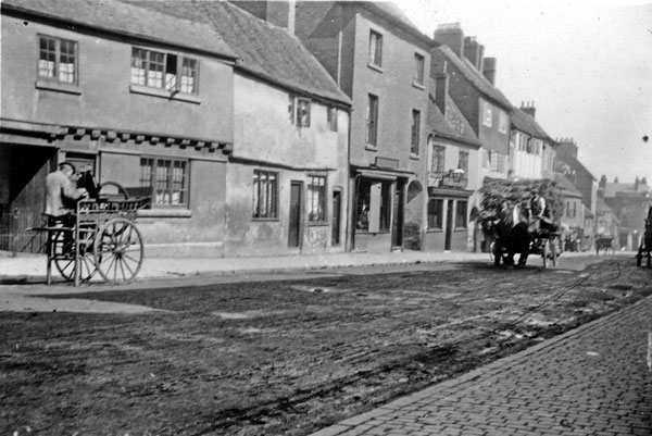
You can see the post office/Blue Pig in this photo.
 Here it is again, just to the left of the cart. 34/35 is part obscured by the cart. The New Inn is way down the hill on the far right
 |
| Streets and Roads - Gosford Street | |
|
dutchman
Spon End |
96 of 263
Wed 9th Sep 2015 3:03pm
On 9th Sep 2015 2:42pm, Prof said:
I am sure there was a well with a pump (like the one that used to be outside St Mary's Hall) so could this be it, and not a post box I wonder?
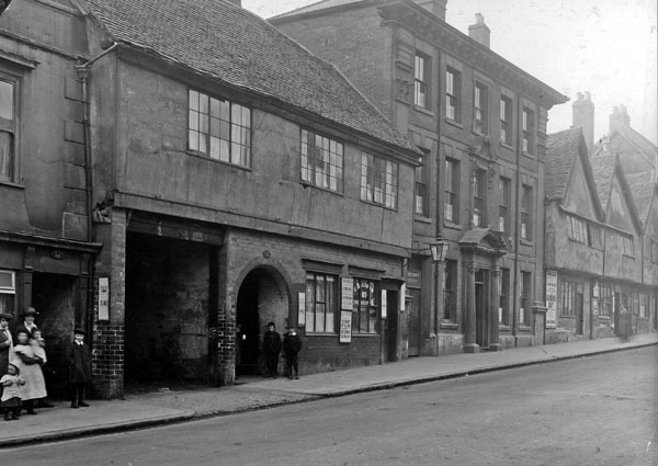
It was definitely a post box as this close-up shows:
 The tall building behind it is the Malt House which was demolished to allow road-widening.
There may have been a pump and horse trough outside the New Inn which looks similar to the Malt House from some angles. Various maps show a letterbox next to the New Inn as well which would correspond to there being a post office next to Luckman's at one time.
The tall building behind it is the Malt House which was demolished to allow road-widening.
There may have been a pump and horse trough outside the New Inn which looks similar to the Malt House from some angles. Various maps show a letterbox next to the New Inn as well which would correspond to there being a post office next to Luckman's at one time.
|
| Streets and Roads - Gosford Street | |
|
Helen F
Warrington |
97 of 263
Wed 9th Sep 2015 3:08pm
Yes, there are a few images showing a post box on the corner of the New Inn. I think they moved it about deliberately to make it harder for me to work out what was where. |
| Streets and Roads - Gosford Street | |
|
dutchman
Spon End |
98 of 263
Wed 9th Sep 2015 3:08pm
On 9th Sep 2015 2:38pm, Prof said:
Many thanks to you all for your contributions. I did not know the post office had moved. Thank you Dutchman for that. Perhaps the pillar box in the earlier picture is the one next to 35.
It moved quite a few times from what I can tell. In the earliest pictures it would have been outside an address between No.60 and No.64 
|
| Streets and Roads - Gosford Street | |
|
Prof
Gloucester |
99 of 263
Thu 10th Sep 2015 6:53pm
Dutchman please tell me how you came by the 1939 Census? There should have been one in 1941 (every ten years) but the War intervened and the latest Census I know to be available is 1911. Would be wonderful if 1939 exists on-line for Coventry. (I was one year in August of that year so two years old at the time of the bombing of Coventry. |
| Streets and Roads - Gosford Street | |
|
dutchman
Spon End |
100 of 263
Thu 10th Sep 2015 7:01pm
A transcript of the Gosford Street entries was posted on another forum in response to a query:
RootsWeb
No other streets were listed.
|
| Streets and Roads - Gosford Street | |
|
Prof
Gloucester |
101 of 263
Thu 10th Sep 2015 7:23pm
Thanks again Dutchman for this fascinating Directory entry for Gosford St. By 1939 my Atkins family had moved to Herbert's Row. |
| Streets and Roads - Gosford Street | |
|
dutchman
Spon End |
102 of 263
Thu 10th Sep 2015 8:46pm
According to old maps Herbert's Row ran north off Gulson Road and had disappeared by 1937. There was however a very similar row only a short distance away deep behind Gosford Street in Court #26.
|
| Streets and Roads - Gosford Street | |
|
Prof
Gloucester |
103 of 263
Fri 11th Sep 2015 3:31pm
Thanks for the map Dutchman, I never knew exactly the site of Herbert's Row and that it was so near to the Workhouse site in fact I thought it was near where the Crown Cinema used to be in Far Gosford St. This is excellent.
Thank you. |
| Streets and Roads - Gosford Street | |
|
Annewiggy
Tamworth |
104 of 263
Wed 7th Oct 2015 5:31pm
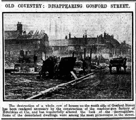
Sorry, not a very clear picture from the newspaper archive, but 100 years ago they were still knocking buildings down to build monstrous new ones.
|
| Streets and Roads - Gosford Street | |
|
dutchman
Spon End |
105 of 263
Wed 7th Oct 2015 6:01pm
Good find Anne
 Here is a repost of the picture in the Aviss Brothers thread showing the buildings which were demolished.
|
| Streets and Roads - Gosford Street | |

Website & counter by Rob Orland © 2024
Load time: 45ms