herberts lad
Exhall
|
76 of 514
Mon 5th Mar 2012 1:06pm
Hi Dutchman
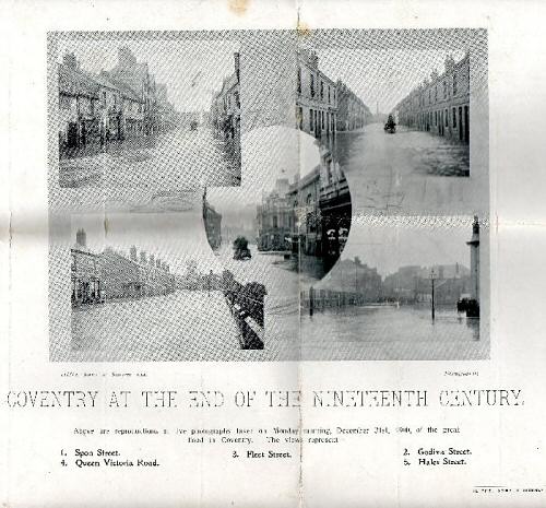
Rooting through some old paperwork I came accross this old supplement Coventry Times 1901 handwritten on the back is an account from an eyewitness it reads
During the night Nov 11th parts of the city were flooded as a consequence of continuous rain the capacity of the rivers and sewers unable to carry the excess water with sufficient rapidity. In High St and West Orchard and the lower parts of Hill St, Spon St,and Bond St were impassable on foot. Cellars were flooded and considerable loss of property was sustained. Thomas St, Moat St and Cash's meadow were 3 feet deep in water. From the Malt Shovel pub at Spon St to St Thomas Church carts were employed to convey persons and property from that neighbourhood and others similar flooding occurred in 1853.
 |
|
Streets and Roads -
Spon Street
|
dutchman
Spon End
|
77 of 514
Mon 5th Mar 2012 2:07pm
Thanks Herbert's Lad 
This is a designated flood zone so there's a 1:100 chance it could happen again in any one year. It almost did a few years ago when the river rose to within eighteen inches of the underside of Windsor Street bridge. Had it reached the top the bridge would then have acted as a damn with water spilling out from either side of it and flooding the entire area to a depth of several inches. In spite of this there was no warning to local residents and no one (except me) even bothered to monitor the river level. We've also had occasional flash-floods which were due to poor drain maintenance rather than heavy rainfall. |
|
Streets and Roads -
Spon Street
|
Midland Red
|
78 of 514
Mon 5th Mar 2012 4:20pm
Thanks for that, HL - most interesting. Some of my ancestors lived in that area, so they must have suffered from the flooding |
|
Streets and Roads -
Spon Street
|
Ang35
Coventry
|
79 of 514
Mon 5th Mar 2012 4:59pm
Hi. I was born in what is now Watch Close, back of Spon Street, in 1950. House (2 up 2 down) was called Lime Tree Cottage, lived next door to Horace and Lil Owen, they had 2 children. They lived there for years. I moved when I was about 6 to Bulkington. My house was where the little car park is now. I think the original wall that is still there nearby was in our back garden.
We had a burglar get in once, my brother luckily had fallen asleep downstairs and the burglar got in through the back window sash. What he didn't know was that my mum had put a small fish tank on the sideboard under the window, so he stepped right in it!! My brother chased him out of the house, water everywhere. He eventually got away in the city centre.
I knew Old Ma Brown’s granddaughter, Ann Brown. Old Ma Brown wore a wig as she was totally bald, and Ann walked into her bedroom, it gave her a shock as she didn't know her grandma was bald! The wig was on her bedside cabinet. I used to go to school in Dover Street to the school with the spire, was the Coventry School of Music years ago after it was a school.
My dad thought he had won the pools once, but my half brother hadn't put the money on at Goddard's shop. My dad never forgave him! We had loads of begging letters when the word got around that we had won, that was before my brother owned up to what he had done. Never did find out how much we would have won. Good job, really!! |
|
Streets and Roads -
Spon Street
|
dutchman
Spon End
|
80 of 514
Mon 5th Mar 2012 6:49pm
Very interesting Angela
Lime Tree Cottages were well back from the street and only a short walk to St John's School.
 |
|
Streets and Roads -
Spon Street
|
Ang35
Coventry
|
81 of 514
Mon 5th Mar 2012 7:02pm
Oh wow, what year is that map? I have never seen my home before on one. I have researched the census and it is on there. How interesting. Is it ok to print off ( for my family tree ) please ? I always ask first.
Angela |
|
Streets and Roads -
Spon Street
|
dutchman
Spon End
|
82 of 514
Mon 5th Mar 2012 7:18pm
On 5th Mar 2012 7:02pm, ang1950 said:
Oh wow, what year is that map?
It's dated 1888 Angela and is the only year for which I could find a large scale map.
On 5th Mar 2012 7:02pm, ang1950 said:
How interesting. Is it ok to print off ( for my family tree ) please ? I always ask first.
That's fine by me Angela, also anything else I post. No need to ask in my case.  |
|
Streets and Roads -
Spon Street
|
Ang35
Coventry
|
83 of 514
Mon 5th Mar 2012 7:38pm
Thank you Dutchman. Most appreciated. |
|
Streets and Roads -
Spon Street
|
Rob Orland
Historic Coventry
|
84 of 514
Mon 5th Mar 2012 8:53pm
On 5th Mar 2012 7:18pm, dutchman said:
On 5th Mar 2012 7:02pm, ang1950 said:
How interesting. Is it ok to print off ( for my family tree ) please ? I always ask first.
That's fine by me Angela, also anything else I post. No need to ask in my case.
Hi both,
Just out of curiosity, and because by coincidence I've chatted with a couple of people about copyright issues recently, do you know that it's definitely alright to use maps from the old-maps.co.uk website? Or if so, then do you know, Dutchman, if we need to add any sort of credit or permission notice? I just want to make sure that none of us will get into any trouble!  |
|
Streets and Roads -
Spon Street
|
dutchman
Spon End
|
85 of 514
Mon 5th Mar 2012 9:56pm
Everyone has their own opinion on the subject Rob and they're usually wrong but ultimately it's up to you what is permissible on your website and what isn't.
As far as I know Old-Maps.co.uk do not own the copyright to any of the maps on their website. They are merely licenced by the Ordnance Survey to display them. The latter permits copying of 'segments' of any of their maps for personal research, legal, educational and non-profit making use. I think also Old-Maps.co.uk is a wholly owned subsidiary of Ordnance Survey and thus bound by their rules?
In addition, a forum owner is not responsible for a post made by someone else unless they or one their staff edit it in some way. It's a legal provision known as 'safe harbour'.
|
|
Streets and Roads -
Spon Street
|
mick
coventry
|
86 of 514
Tue 25th Sep 2012 2:53pm
I assumed that this article referred to Windsor Street. It is interesting that new streets were regularly being imposed on the old mediaeval layout of the city - Hertford St in the early 19th century, Windsor St, and Queen Victoria Road around the turn of the century and Corporation St and Trinity St in the 1930s. Does anybody know when Queen Victoria Rd was cut and the circumstances leading to it? |
|
Streets and Roads -
Spon Street
|
dutchman
Spon End
|
87 of 514
Tue 25th Sep 2012 3:14pm
On 25th Sep 2012 2:53pm, mick said:
I assumed that this article referred to Windsor Street.
It does I was surprised at how much older the south end of Windsor Street is compared to the north end. There was a similar situation in Whitefriars Street, the north end not being driven through until long after the south end was built.
On 25th Sep 2012 2:53pm, mick said:
Does anybody know when Queen Victoria Rd was cut and the circumstances leading to it?
1887. It was to create a bypass between Holyhead Road and Warwick Road.
|
|
Streets and Roads -
Spon Street
|
dutchman
Spon End
|
88 of 514
Tue 25th Sep 2012 4:22pm
Nos 6-8 Spon Street were demolished to make way for Queen Victoria Road.
Garfield Road became the headquarters of the Rover Car Company and was later renamed Rover Road although most people think of it as the entrance to the market.
|
|
Streets and Roads -
Spon Street
|
Foxcote
Warwick
|
89 of 514
Wed 26th Sep 2012 8:52am
On 22nd Sep 2012 12:31pm, dutchman said:
Yard 47: Cook's Yard. The entrance was widened to allow a cycle factory to be accessed behind it. It currently goes by the name of Watchmaker's Close.
Would that be the Court that took you to 'Limetree Cottages', I know a lady wrote in about them recently and I found them on the census. |
|
Streets and Roads -
Spon Street
|
dutchman
Spon End
|
90 of 514
Wed 26th Sep 2012 2:17pm
No Foxcote,. That was Court 37, further west, on the other side of what is now the Ring Road. |
|
Streets and Roads -
Spon Street
|

