Helen F
Warrington
|
376 of 514
Tue 29th Jan 2019 1:54pm

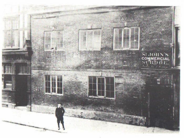
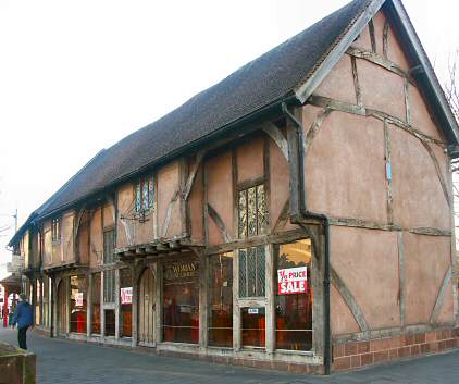
There were three buildings on the corner of Spon Street and Holyhead Road 2.3 of which can be seen in the photo above. There is a better version of the third building somewhere with a kid stood in front of what was a fairly grim looking building and a sign over the door/passageway saying 'St John's Commercial School.' In 1850 that was the Rising Sun and a building at the back, parallel with Holyhead Road was the Fairfax School. The Rising Sun moved to the left, at which point the school may have taken over the building on the Street and renamed itself. The Rising Sun (in its new position) and the building to the left of that were then demolished to build the current Rising Sun. The school also changed and the building now called the Fairfax House appeared - how many, if any original buildings are part of that block, I don't know but the sign says that the house was rebuilt in 1901. Charity set up in 1731.
Confused? I was. The number of times things moved is very bewildering when you try to correlate maps with images.
|
|
Streets and Roads -
Spon Street
|
Heathite
Coventry
|
377 of 514
Tue 29th Jan 2019 3:48pm
|
|
Streets and Roads -
Spon Street
|
Helen F
Warrington
|
378 of 514
Wed 30th Jan 2019 11:21am
It looks like the school had gone by that point. It would have been about 182 Spon Street. Thanks Heathite. |
|
Streets and Roads -
Spon Street
|
Annewiggy
Tamworth
|
379 of 514
Wed 30th Jan 2019 3:06pm
Fairfax School, also known as the Green Gift School merged with Bablake in 1888 |
|
Streets and Roads -
Spon Street
|
Heathite
Coventry
|
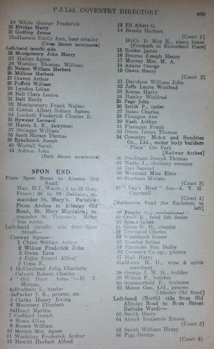
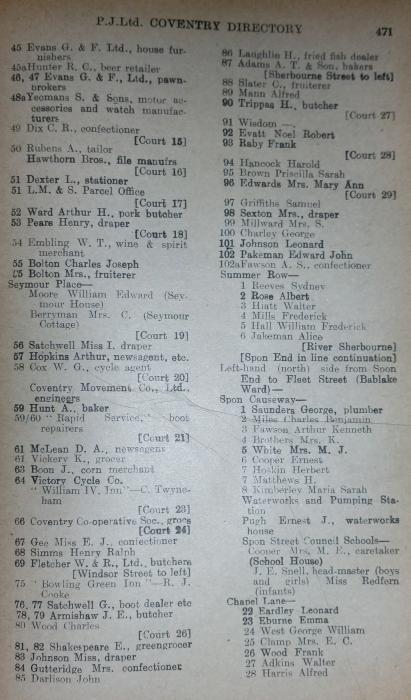
380 of 514
Wed 30th Jan 2019 4:13pm
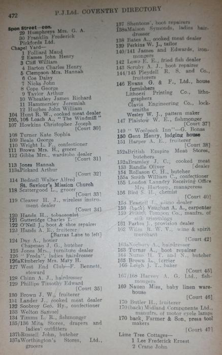
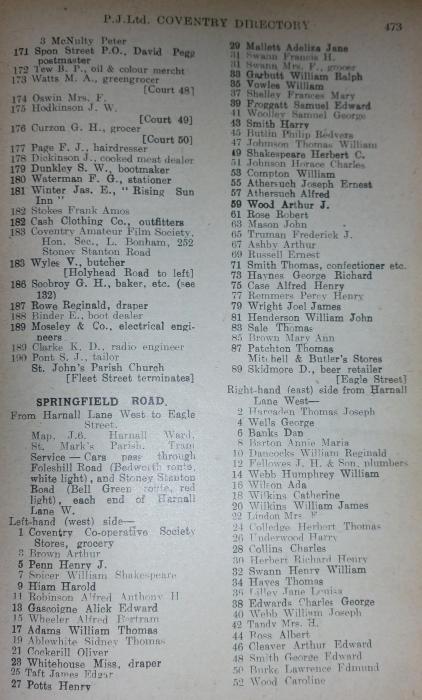
Thanks for the info. Here's an image from an 1874 directory. Seems to tally 

|
|
Streets and Roads -
Spon Street
|
marenqo
Newcastle
|
381 of 514
Thu 2nd May 2019 12:10am
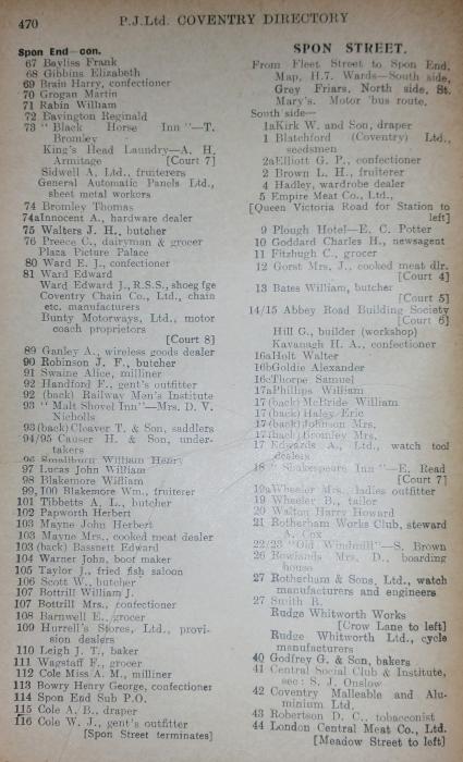
I have a question about 123a Spon Street, the Black Swan Terrace (now "Moira's Wet Fish" shop) - does anyone know who Moira was?
Thus far, I could trace its long history through the great Real Ale Rambles website. That link, however, ends in 1909 with the famous airplane story.
After that the building seems to have been taken over by "Hands, A. E." who was a "fruiterer" (according to the 1935 registry, kindly cited above). It then belongs to Walter and Emily Westbury, green-grocers and fruiterers ( History of Black Swan Terrace), but I can't find information on the later occupants. I am especially interested in the person Moira.
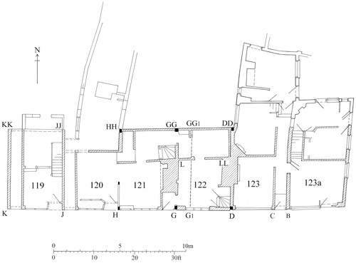
The map above comes from Bob Meeson & Nat Alcock (2016) Black Swan Terrace, Upper Spon Street, Coventry: A Comparison of Medieval Renters, Vernacular Architecture, 47:1, 1-19, DOI: 10.1080/03055477.2016.1234299 |
|
Streets and Roads -
Spon Street
|
NeilsYard
Coventry
|
382 of 514
Mon 28th Oct 2019 5:04pm
As referenced by Helen in post #377 -
 |
|
Streets and Roads -
Spon Street
|
Helen F
Warrington
|
383 of 514
Mon 28th Oct 2019 5:21pm
Yes Neil, that's the one. |
|
Streets and Roads -
Spon Street
|
Midland Red
|
384 of 514
Mon 28th Oct 2019 5:22pm
On 2nd May 2019 12:10am, marenqo said:
I have a question about 123a Spon Street, the Black Swan Terrace (now "Moira's Wet Fish" shop) - does anyone know who Moira was?
Thus far, I could trace its long history through the great Real Ale Rambles website. That link, however, ends in 1909 with the famous airplane story.
After that the building seems to have been taken over by "Hands, A. E." who was a "fruiterer" (according to the 1935 registry, kindly cited above). It then belongs to Walter and Emily Westbury, green-grocers and fruiterers ( History of Black Swan Terrace), but I can't find information on the later occupants. I am especially interested in the person Moira.
I believe that a lady named Moira ran the shop in the 1990s, living there with her family |
|
Streets and Roads -
Spon Street
|
NeilsYard
Coventry
|
385 of 514
Mon 28th Oct 2019 5:25pm
Is anyone aware of a Cov Telegraph collection from the early 60's of Spon Street - the east section. Someone has contacted me desperately looking for a photo they know the Telegraph have from there and that time as it included some family members walking past? I have looked at most things I have - so far without joy. Specifically 1963-65, around the Watch Close area. |
|
Streets and Roads -
Spon Street
|
Midland Red
|
386 of 514
Mon 28th Oct 2019 5:46pm
|
|
Streets and Roads -
Spon Street
|
NeilsYard
Coventry
|
387 of 514
Tue 29th Oct 2019 9:19am
Yes, thanks Cliff, I had seen that one, but a bit later. |
|
Streets and Roads -
Spon Street
|
NeilsYard
Coventry
|
388 of 514
Tue 12th Nov 2019 11:39am
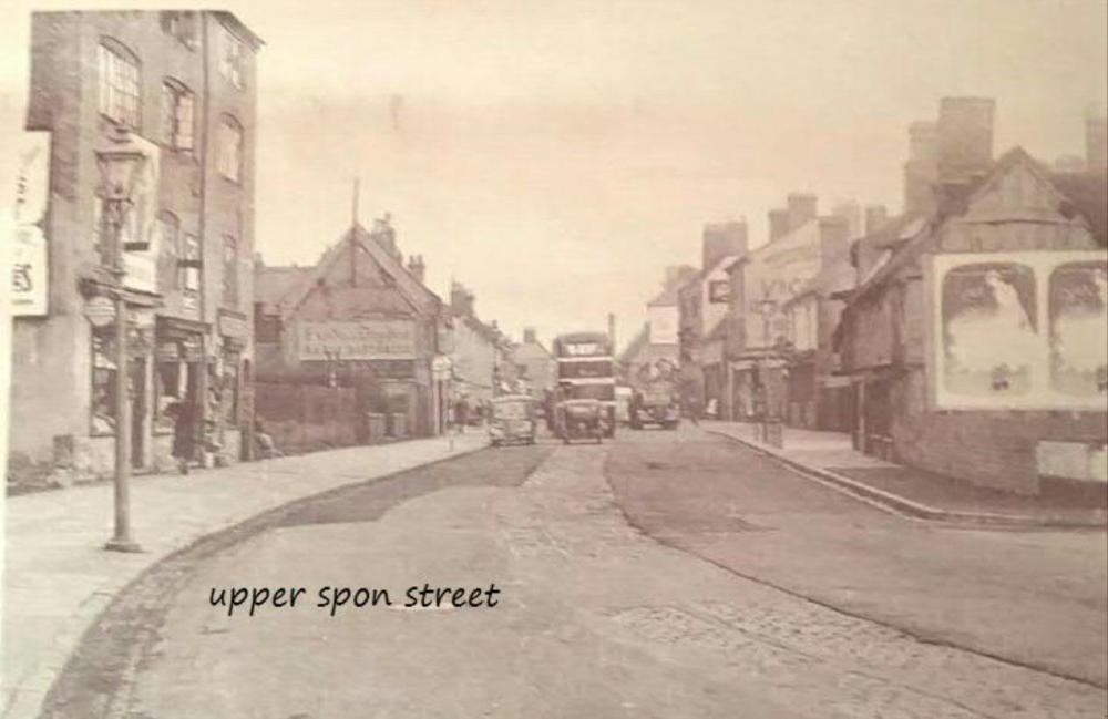
Terrific image of what is now classed as Upper Spon St, the Weavers Cottage complex on the left. Apologies about the writing as this came from the True Cov FB page and my friend Dean Nelson so credit to them. I think I am right in saying opposite where the bus is is the original Bowling Green pub by the junction with Windsor St - some rarely captured-on-camera buildings in this one. Note how they have tarmaced over the cobbles and tramlines.
 |
|
Streets and Roads -
Spon Street
|
NeilsYard
Coventry
|
389 of 514
Fri 22nd Nov 2019 2:28pm
Spon Street West in 1968, looking west, George Poole House in the background to the left. All about to be pulled down for new Social Housing. You can just see the 'New Bowling Green' pub in the background down the road on the very right by the corner of Windsor Street which was built in 1959. I think that is also the King William IV pub in between.
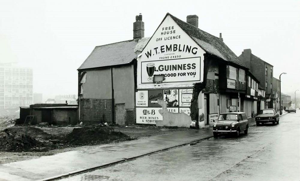
(c) Historic England |
|
Streets and Roads -
Spon Street
|
Helen F
Warrington
|
390 of 514
Fri 22nd Nov 2019 2:34pm
The ones in the foreground were taken down and rebuilt near St John's in their medieval appearance.
 |
|
Streets and Roads -
Spon Street
|

 Spon End & Spon Street 1935.