
|
Annewiggy
Tamworth |
301 of 494
Mon 29th Jul 2019 12:37pm
Just reading through "A Harvest of History" about the life of J B Shelton. He says the west end of Smithford Street adjoining Fleet Street was called Ram Bridge Place. He mentions that a large water mill was discovered at a depth of 12ft 6in at the north west corner of Woolworths and that timbers of a great size, which had been mortised out were found and were probably used to hold the flood gate, which was called the "Ram" which more than likely gives its name to Ram Bridge Place. |
| Streets and Roads - Smithford Street (inc. Ram Bridge) | |
|
Kaga simpson
Peacehaven, East Sussex |
302 of 494
Tue 30th Jul 2019 9:51am
Annewiggy, that's interesting, was there a sort of diagram? |
| Streets and Roads - Smithford Street (inc. Ram Bridge) | |
|
Helen F
Warrington |
303 of 494
Tue 30th Jul 2019 11:47am
I wish Kaga, I wish. While the loss of Shelton's pre war artefacts is heart breaking, the loss of excavation details including maps and sketches is worse. I'm slowly putting locations to dig descriptions and photos that were taken at the time. Shelton didn't have access to the number of early images I have, so in some cases I probably have a picture of a standing building he later dug up eg, there is an image of a building that spanned the river between the West Orchard bridge and the Ram Bridge, which might well be the mill, although no water wheel was in evidence by then. If I knew exactly where he was digging, I could perhaps match the two up.
I'm currently trying to work out the subteranean features including descriptions, sketches and photos. It's a knotty problem that I pick up and put down, as and when I'm in the mood. A lot of the images of cellars turn out to be of the same two - one on the High Street under what is now the Halifax and the Coventry Building Society and the other is uder a council building that is on the site of the Old Star, opposite Bayley Lane. I've yet to work out how many crypts/cellars there were or if there was a true pattern to where they were located.
|
| Streets and Roads - Smithford Street (inc. Ram Bridge) | |
|
Annewiggy
Tamworth |
304 of 494
Tue 30th Jul 2019 12:47pm
Sorry Kaga. It is only a booklet I have listing some of the excavations he has done. The only diagram is one of Trinity Street. |
| Streets and Roads - Smithford Street (inc. Ram Bridge) | |
|
Prof
Gloucester |
305 of 494
Tue 10th Sep 2019 2:43pm
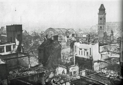
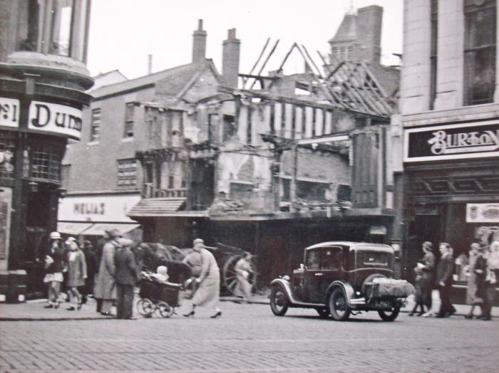
Smithford St rather than Broadgate I think. Helen F may know the white building, right centre of photo?
|
| Streets and Roads - Smithford Street (inc. Ram Bridge) | |
|
Kaga simpson
Peacehaven, East Sussex |
306 of 494
Tue 10th Sep 2019 3:02pm
Prof,
looks like Burtons. |
| Streets and Roads - Smithford Street (inc. Ram Bridge) | |
|
Helen F
Warrington |
307 of 494
Tue 10th Sep 2019 3:14pm
It is Smithford Street and it does look like Burtons but I think it was this building on the right, a bit further east than Burtons.
 I don't know what it was used for.
 |
| Streets and Roads - Smithford Street (inc. Ram Bridge) | |
|
Midland Red
|
308 of 494
Tue 10th Sep 2019 3:56pm
The one in your photo, Helen, is The Picture House. |
| Streets and Roads - Smithford Street (inc. Ram Bridge) | |
|
Prof
Gloucester |
309 of 494
Tue 10th Sep 2019 4:20pm
Doesn't seem to be a corner site though Kaga! |
| Streets and Roads - Smithford Street (inc. Ram Bridge) | |
|
Midland Red
|
310 of 494
Tue 10th Sep 2019 5:07pm
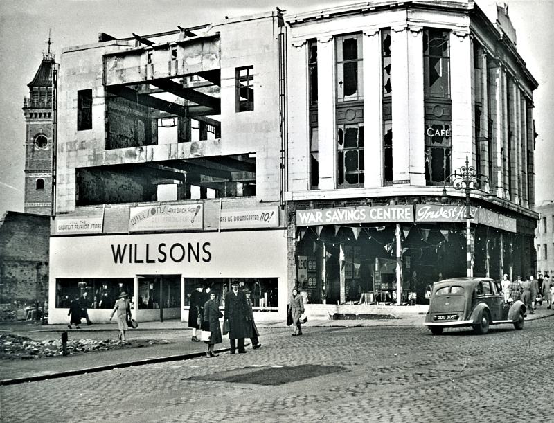
If I read everything correctly (not very usual!), Burtons building on the corner of Broadgate and the one attached next door in Smithford Street (Willsons) remained standing after the war. I think the building in question was another two down from that one, so it's possible that it was Dolcis Shoes. |
| Streets and Roads - Smithford Street (inc. Ram Bridge) | |
|
Rob Orland
Historic Coventry |
311 of 494
Wed 11th Sep 2019 9:14am
Yep, what MR said above.....
 |
| Streets and Roads - Smithford Street (inc. Ram Bridge) | |
|
NeilsYard
Coventry |
312 of 494
Wed 11th Sep 2019 10:21am
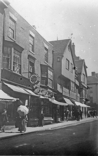
I think this is the same building that Rob has in the Library Collection from a lot earlier -
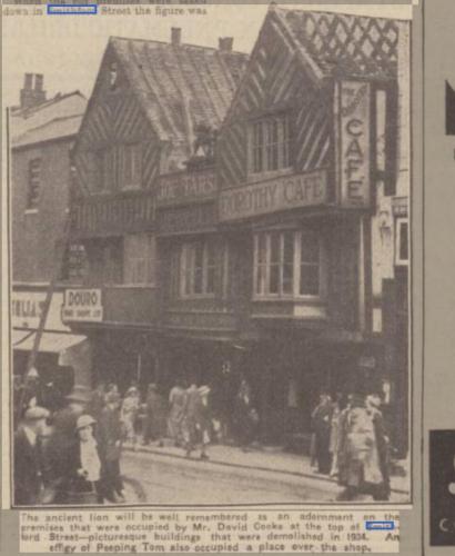
 The gap to the right of the white building in question was I think where the Dorothy Cafe was - that went in 1934. We know this thanks to this clipping that I think Anne shared some time ago - where Willsons is in Robs image :
 Also here - is that the same building though to the left? It looks significantly different (and shorter!) than in Prof's photo in Post #326, as if it had only just had a 'modern' deco facelift -
 |
| Streets and Roads - Smithford Street (inc. Ram Bridge) | |
|
Kaga simpson
Peacehaven, East Sussex |
313 of 494
Wed 11th Sep 2019 12:13pm
Midland Red.
I think you're right, but then you know camera angle shots better than I. Prof's photo was a wartime shot that altered daily, the building in question was nowhere near the size of Burtons in height, the building on the right was Easterns, set back a couple of yards, in between Dolcis and Willsons. Easterns was removed leaving Prof's photo, a few weeks later Dolcis was removed and the top part of Willsons was left derelict, only the ground floor was renovated as a shop. The house this side of the road was part of the Kings Head. |
| Streets and Roads - Smithford Street (inc. Ram Bridge) | |
|
Helen F
Warrington |
314 of 494
Wed 11th Sep 2019 12:52pm
To get back to the Prof's photo. It doesn't look like it was Burtons or Willsons because there are destroyed buildings to the right. I still think that it might be the remains of the picture theatre. It's the only white painted building west of Willsons.
View from Britain from above
|
| Streets and Roads - Smithford Street (inc. Ram Bridge) | |
|
Kaga simpson
Peacehaven, East Sussex |
315 of 494
Wed 11th Sep 2019 1:17pm
Helen F.
Sorry but what date are you looking at? On the night of the blitz, two buildings were glossy white, the one next to Willsons and the one next door below it - both got damaged, and everything below them down to Fleet Street was wiped out. Prof's photo was taken from above ground level and that is a puzzle for everything had been destroyed opposite Willsons. |
| Streets and Roads - Smithford Street (inc. Ram Bridge) | |

Website & counter by Rob Orland © 2024
Load time: 23ms