
|
Helen F
Warrington |
211 of 514
Wed 20th Apr 2016 3:11pm
Rare photo alert!!! Please visit the site and look at the photos, most of them I've never seen before especially the ones of Spon Street. They're outstanding and very, very early. They show the middle part of Spon Street looking towards Crow Lane and the City.
Try cut and paste instead, link doesn't work as a live link
http://fourtoes.co.uk/iblog/wet-plate-negatives-of-coventry/ |
| Streets and Roads - Spon Street | |
|
Annewiggy
Tamworth |
212 of 514
Wed 20th Apr 2016 3:30pm
The link doesn't seem to work Helen |
| Streets and Roads - Spon Street | |
|
Helen F
Warrington |
213 of 514
Wed 20th Apr 2016 3:58pm
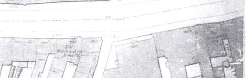
Better? Identified at the site are the Lamb and Flag and the Woolpack. On the right of the photo closeup behind the horse is the Watchmakers Arms (not the one on the corner but the one with the sign, because there was one demolished after the photo was taken.) |
| Streets and Roads - Spon Street | |
|
dutchman
Spon End |
214 of 514
Wed 20th Apr 2016 4:37pm
The pole belonged to a barber's shop "Nicks" at No.35 on the corner of Crow Lane. It must have been absorbed into the pub when the Watchmaker's Arms was rebuilt.
 |
| Streets and Roads - Spon Street | |
|
Annewiggy
Tamworth |
215 of 514
Wed 20th Apr 2016 4:38pm
Yes Helen, copy and paste works. I have posted that I think the row of large houses is Stoneleigh Terrace. Another one, the one with th steps up the front and the railings looks like the Stone House at Allesley |
| Streets and Roads - Spon Street | |
|
Helen F
Warrington |
216 of 514
Wed 20th Apr 2016 4:50pm
There was an additional building on the corner of Crow Lane when this photo was taken. When the factories were built the road was widened on the west side by a row. The medieval building under the spire is the Mechanics Arms. The recessed building went all the way to the corner of Crow Lane and the building that is in the picture of Crow Lane on the left wasn't built until later.
|
| Streets and Roads - Spon Street | |
|
dutchman
Spon End |
217 of 514
Wed 20th Apr 2016 6:58pm
Thanks Helen  |
| Streets and Roads - Spon Street | |
|
Helen F
Warrington |
218 of 514
Fri 22nd Apr 2016 10:02pm
|
| Streets and Roads - Spon Street | |
|
Helen F
Warrington |
219 of 514
Fri 22nd Apr 2016 10:06pm
Some time between 1750 and 1850 the area opposite St John's was widened. Does anybody know how many houses there were between the corner of Fleet Street and the gate or Conduit Street? |
| Streets and Roads - Spon Street | |
|
Dreamtime
Perth Western Australia |
220 of 514
Sat 23rd Apr 2016 8:37am
Had to giggle over your last post Helen but have to let you know I wasn't around at that time !!!! I know what you mean though and I am not so cluey as you with the old maps, but I do enjoy looking at them when you members find them.  |
| Streets and Roads - Spon Street | |
|
Helen F
Warrington |
221 of 514
Sat 23rd Apr 2016 10:00am
You mean you haven't been issued with a time machine?  I don't know how the various street records and censuses work, but I was hoping there might be a list of households between two recognisable points. It's a long shot. Someone might be able to suggest where I look if they haven't got the stretch I'm interested in.
 |
| Streets and Roads - Spon Street | |
|
dutchman
Spon End |
222 of 514
Sun 24th Apr 2016 12:52am
On 22nd Apr 2016 10:06pm, Helen F said:
Some time between 1750 and 1850 the area opposite St John's was widened.
Post 1800 as far as I can tell Helen.
On 22nd Apr 2016 10:06pm, Helen F said:
Some time between 1750 and 1850 the area opposite St John's was widened. Does anybody know how many houses there were between the corner of Fleet Street and the gate or Conduit Street?
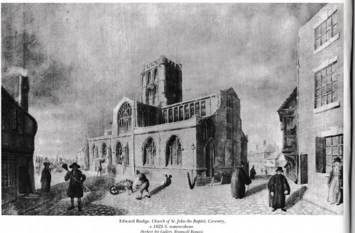
Afraid not Helen but at least one building was a pub by the looks of this 1817 engraving, The Duke of Cumberland perhaps?

|
| Streets and Roads - Spon Street | |
|
Helen F
Warrington |
223 of 514
Sun 24th Apr 2016 3:43am
Thanks for narrowing the date range down Dutchman. I feared it would be that end. The image is a good one and from the right period but I need the other side of the gate. It does have a hint of what was there on the right, that would become Conduit Street. There are pictures of the other side and I've an idea what the last building looked like - a butchers it seems. It looks three storey but a bit odd. The others were probably two storey jettied like the corner with Fleet Street. I'm resigned to just guessing what they looked like but it would help if I knew how many separate properties there were. I need to learn about the written records and how to use them.  |
| Streets and Roads - Spon Street | |
|
dutchman
Spon End |
224 of 514
Sun 24th Apr 2016 4:51am
Ah, I assumed the pub was on the Fleet Street side Helen
 If it was on the Spon Street side there's no way it's postal address could have been No.21 as quoted in some sources, more like No.190.
As far as I can tell from old maps Helen, the original entrance to Conduit Yard was the space later occupied by No.21 Fleet Street, hence its irregular shape:
If it was on the Spon Street side there's no way it's postal address could have been No.21 as quoted in some sources, more like No.190.
As far as I can tell from old maps Helen, the original entrance to Conduit Yard was the space later occupied by No.21 Fleet Street, hence its irregular shape:

|
| Streets and Roads - Spon Street | |
|
Helen F
Warrington |
225 of 514
Sun 24th Apr 2016 8:07am
It's a very complicated city The pictures don't come with instructions.
As far as I can gather the Conduit Yard road must have been there even when the wall was still standing. The wall was just beyond under the first row of houses. The funny shape of 24 is because that was where the original line of the road was. From there until you get beyond the George IV, it's all new build. You're right, there was a gap about the position of 21 into block. I think the whole area was flattened and rebuilt to give an easier turn onto Spon street and Hill Street. At that time there was no curving wall around the front of the church and the entrance to St Johns was on the Hill Street end. It's shown best in this picture posted by Anne.
You can see the corner on the left and that there isn't a tall building next door. There's also no shadow, so demolition might have already been underway.
|
| Streets and Roads - Spon Street | |

Website & counter by Rob Orland © 2024
Load time: 194ms