 Follow the fence in from the left to the gable end of a building, that's the east side of court 3. You can see the end of the court and the gable end of the west side of court 3.
|
Helen F
Warrington |
211 of 379
Fri 22nd Nov 2019 3:31pm
Your host provides.
Though court 3 is on the other leg of New Buildings, next to where the mill pool was originally (later the cattle market). So Court 3 is this view
Follow the fence in from the left to the gable end of a building, that's the east side of court 3. You can see the end of the court and the gable end of the west side of court 3. |
| Local History and Heritage - More mystery scenes | |
|
Kaga simpson
Peacehaven, East Sussex |
212 of 379
Sat 23rd Nov 2019 10:15am
Helen
We have posted about this scene before. Those cottages before the railings about 1790 were in Silver Street, opposite the Smithfield in Hales Street. There was only a small flagstone path between the front door and the pool. Mr H was a small dealer in cattle and this was his fourth wife, they also had a small baby. He had gone out, so thinking he wouldn't be back for some time, she took the baby in her arms, she visited Mr and Mrs B who got their living by a hand loom. They lived in a cottage by the mill dam. After an hours gossip she left, it was a very dark windy night. Mr H came home to find no one there so he visited his wife's father's house at the back of the Golden Lion pub in New Buildings. Fearing something might have happened they lit a lantern and with the help of neighbours dragged the pool. They found her lifeless body but not the baby. Next morning they found the baby had floated onto the roots of that great ash tree, named 'Old Nick' - was taken out alive. But this was his fourth wife, and raised a cry in the city. Nothing however could be proved, but the authorities built a stone kerb and placed the railings there.
PS the clock on the church is interesting? |
| Local History and Heritage - More mystery scenes | |
|
Helen F
Warrington |
213 of 379
Sat 23rd Nov 2019 10:54am
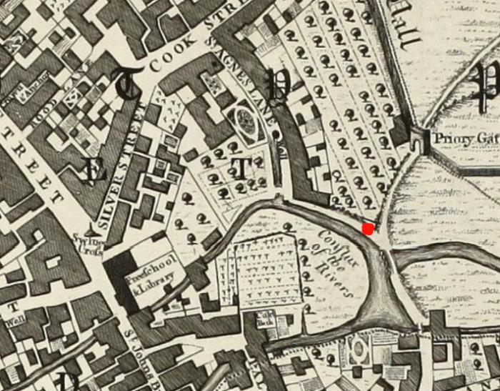
Yes to everything Kaga except 'Those cottages before the railings about 1790 were in Silver Street'. You're thinking of St Agnes Lane which met New Buildings (the lane behind the fence in the sketch) at the sluice gates to the pond. The pond was drained to become the cattle market and Hales Street was built over the Radford Brook (foreground of the sketch). See map. The artist would have been roughly at the red spot looking south east.
|
| Local History and Heritage - More mystery scenes | |
|
Kaga simpson
Peacehaven, East Sussex |
214 of 379
Sat 23rd Nov 2019 11:28am
Helen
Yes, Helen, I wrote it wrongly, the woman lived in Silver Street and was visiting the people by the pool. |
| Local History and Heritage - More mystery scenes | |
|
Helen F
Warrington |
215 of 379
Sat 23rd Nov 2019 11:45am
It's a very confusing area. New Buildings was called Priory Lane at the time the map was drawn and seems to head off east towards Hilltop. But did it also split and head north towards the dam as New Buildings did? St Agnes Lane seems to stop at the pond but did it in fact turn east and continue on to the dam and/or to the Swanswell gate? Did any of these roads have names of their own? |
| Local History and Heritage - More mystery scenes | |
|
Kaga simpson
Peacehaven, East Sussex |
216 of 379
Sun 24th Nov 2019 4:05pm
Helen,
The old free school was pulled down then re-built in 1794 to widen the road. It was said the old headmaster had rheumatic pain in the legs, so he sat with his feet in a green baize bag filled with sheep's wool to keep them warm. |
| Local History and Heritage - More mystery scenes | |
|
Rob Orland
Historic Coventry |
217 of 379
Sun 24th Nov 2019 5:24pm
The Free School wasn't pulled down Kaga - only about 6 feet or so of the west side of it was removed, in order to widen Bishop Street.
I've highlighted the change with this Now and Then pairing.
The whole school library was pulled down though (on the south side, right side of the picture) to make way for the building of Hales Street. |
| Local History and Heritage - More mystery scenes | |
|
Kaga simpson
Peacehaven, East Sussex |
218 of 379
Mon 25th Nov 2019 10:57am
Rob, well you can't really argue with those photgraphs, but I quoted from a book of 1888 that said:
The old free school the front of which towards the Burges was pulled down and rebuilt to widen the roadway in the year 1794 (and that was all it said about the building). |
| Local History and Heritage - More mystery scenes | |
|
Helen F
Warrington |
219 of 379
Mon 25th Nov 2019 11:07am
It's a matter of punctuation or sentence construction (both of which I fail regularly). One way it could be read that the school that fronts onto the Burges was pulled down and rebuilt. The other way is that the front of the school in the Burges was pulled down and rebuilt. Other evidence points to the latter meaning being correct. Though the entire structure has experience so many alterations it might as well have been totally rebuilt. |
| Local History and Heritage - More mystery scenes | |
|
Midland Red
|
220 of 379
Fri 29th Nov 2019 4:42pm
On 22nd Nov 2019 3:31pm, Helen F said:
Your host provides.
Though court 3 is on the other leg of New Buildings, next to where the mill pool was originally (later the cattle market). So Court 3 is this view
This post has been copied into the Holy Trinity Church thread, and all conversations regarding the clock/s on the church spire/tower have been moved to that thread
Follow the fence in from the left to the gable end of a building, that's the east side of court 3. You can see the end of the court and the gable end of the west side of court 3. |
| Local History and Heritage - More mystery scenes | |
|
Helen F
Warrington |
221 of 379
Mon 2nd Dec 2019 1:03pm
On 22nd Nov 2019 3:26pm, NeilsYard said:
Does anyone have a better map of New Buildings including the courts on the southern side. Annoyingly Old-Maps earliest one seems to cut that off, especially after the location of Court No.3 as it appears my great grandfather and family were there in the 1881 census.
To go back to the original question - it's always worth checking out the fire insurance maps (either those at the British Library or Rob's later versions.)
Fire insurance Sheet 3.1
|
| Local History and Heritage - More mystery scenes | |
|
NeilsYard
Coventry |
222 of 379
Tue 28th Apr 2020 2:39pm
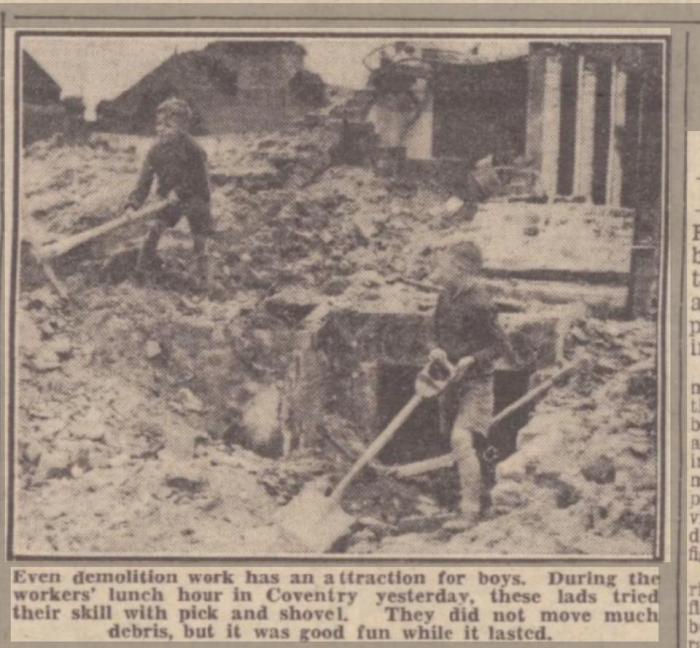
Not much to go on but can anyone identify this wartime scene? A FB Old Cov member has pulled it out of an old clipping from the Herbert as he is one of the boys but cannot recall where it was? His dad had always thought it was either in the Far Gosford Street or Little Park Street areas as they lived there during the war. I wasn't sure if that was part of the Much Park Street Brewery in the background?
|
| Local History and Heritage - More mystery scenes | |
|
Helen F
Warrington |
223 of 379
Fri 1st May 2020 11:08am
It's a tough one Neil. It doesn't ring any bells yet, but there is a substantial open area between the boys and the buildings in the distance. |
| Local History and Heritage - More mystery scenes | |
|
NeilsYard
Coventry |
224 of 379
Fri 1st May 2020 11:47am
Yes Helen - that's almost like a columned structure to the side and if that's a cellar the damage has gone well down. The original poster on FB reckons it's by the Police Station. |
| Local History and Heritage - More mystery scenes | |
|
NeilsYard
Coventry |
225 of 379
Fri 1st May 2020 4:40pm
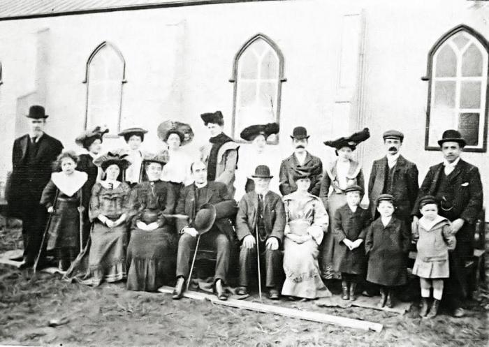
And another FB challenge! Anyone recognise the church building?
|
| Local History and Heritage - More mystery scenes | |

Website & counter by Rob Orland © 2024
Load time: 179ms