
|
NeilsYard
Coventry |
151 of 200
Mon 25th Nov 2019 12:54pm
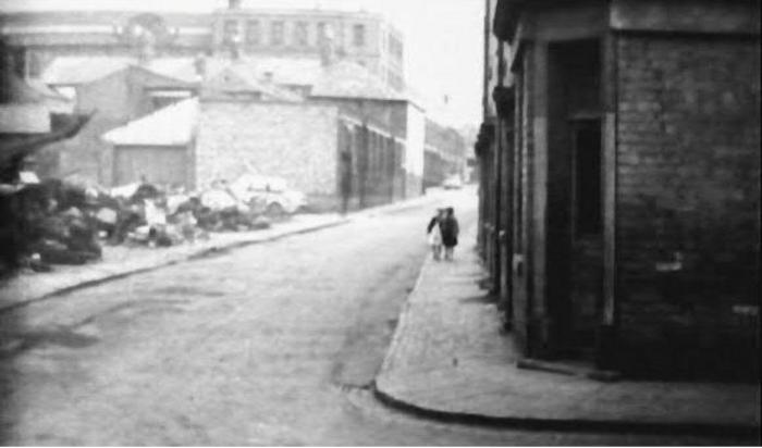
Thanks to John Gregory from the True FB page, I think this is the first ground level pre Ring Road image I have seen of York Street, junction with Moat Street -
|
| Streets and Roads - Albany Road / Butts | |
|
NeilsYard
Coventry |
152 of 200
Fri 20th Mar 2020 2:52pm
Here's an unusual view of Butts / York Street area before the Ramada Tower went up. Thanks to my friend Cliff Berwick.
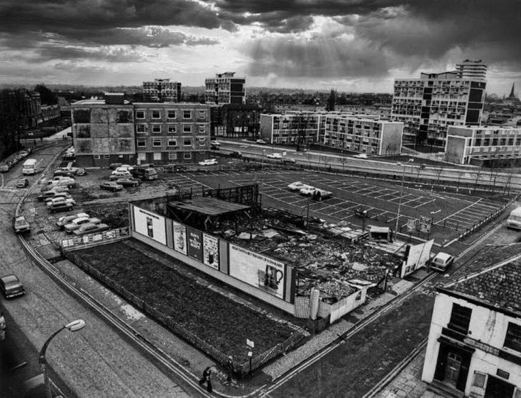
|
| Streets and Roads - Albany Road / Butts | |
|
NeilsYard
Coventry |
153 of 200
Fri 6th Nov 2020 9:28am
I think we have referenced it before but for those not local - they have finally started to build what appear to be houses on the 'gap' that seems like its been there forever between properties on Albany Road - just opposite the junction with Broadway. It's always only ever been a grassed gap to me with advertising hoardings. My mum was brought up just behind in Newcombe Road and she says its been like that ever since she was born which was 1942. I always thought it might have been a space caused by bomb damage but looking at old maps it appears that it's always been like that for some reason. I drive past most days and could not see any evidence of rubble being dug out of any old foundations that may have been there before. Anyone know why it was like left like that when there was a row of terracing beside it? It's this spot. |
| Streets and Roads - Albany Road / Butts | |
|
moriarty
allesley park coventry |
154 of 200
Fri 6th Nov 2020 10:08am
I think photo 153 shows the remains of Roach's Scrapyard, which was opposite the Tech. It had an entrance onto the Butts at one time but in the photo it's moved down the side. The 60's flats don't seem to have fared well either. |
| Streets and Roads - Albany Road / Butts | |
|
Helen F
Warrington |
155 of 200
Fri 6th Nov 2020 10:30am
Neil, looking at the maps and stepping back, I think the land may possibly have originally been shared. They liked to give people a bit of land with every house but on both sides of the plot between the two roads the angles mean that several houses were short changed, so to the north it looks like shed/garages and to the south a garden, possibly belonging to what is now the funeral directors. I note that the houses on the two sides of the garden plot are different. Maybe the first builder to the right just failed to build on the land? Maybe it's where the stonemason used to work on the gravestones? |
| Streets and Roads - Albany Road / Butts | |
|
Slim
Another Coventry kid |
156 of 200
Fri 6th Nov 2020 12:48pm
As I got bigger, I wanted a bigger bike, so my mate who was into bikes sold me one. Admittedly it needed a bit of work, but when my dad saw it he said "where did you get that, Roach's yard?" It was his sarcastic way of saying it was tat. He often used that expression if he disproved of something. Of course, at first I didn't know what he meant, so he had to explain. Now I know where it was. I think that was classed as Earlsdon in the olden days. From what he told me, I gather Roach's was well known as the scrapyard, even when he was lad. |
| Streets and Roads - Albany Road / Butts | |
|
Annewiggy
Tamworth |
157 of 200
Fri 6th Nov 2020 3:14pm
In 1906 J G Gray was the owner developer who in Coventry Collections is listed as applying for planning for 3 houses at 116-120 Albany Road (the 2 buildings occupied by Grimmet and Timms and the house, now a shop, next door).
In 1924 E J Sutton was the owner developer for 128-146 Albany Road and was applying for planning for 10 houses.
There is no mention of 122-126.
Current planning on the Coventry site shows a planning application for 3 shop units, 122-126. It does say the space was either left as a quiet area which would explain the steps leading up to it or it does say bomb damage but on the 1939 Register there are no houses with those numbers listed, so that does not seen likely.
We have two gaps in the house numbers in the road that we live on. Most of the houses were built as council houses after the war and issued in blocks to various builders. Maybe this happened in Albany Road. |
| Streets and Roads - Albany Road / Butts | |
|
Positively Pottering
East Midlands |
158 of 200
Fri 19th Mar 2021 3:10pm
Sorry, I don't want to gatecrash this topic but have just discovered that my grandmother resided at Court 2 House 5, Butts in 1911.
I've looked at post 7, 8 and 9 of the Taylor Family topic but I'm afraid I can't see where that was.
Any help please? |
| Streets and Roads - Albany Road / Butts | |
|
Helen F
Warrington |
159 of 200
Fri 19th Mar 2021 3:39pm
Court 2, house number 5
Try this. Right next to the river.  |
| Streets and Roads - Albany Road / Butts | |
|
NeilsYard
Coventry |
160 of 200
Fri 19th Mar 2021 4:31pm
So, right behind the petrol station today. |
| Streets and Roads - Albany Road / Butts | |
|
Positively Pottering
East Midlands |
161 of 200
Sat 20th Mar 2021 10:24am
On 19th Mar 2021 3:39pm, Helen F said:
Court 2, house number 5
Try this. Right next to the river.
Hi Helen F
Thank you for your response.
Forgive me, I ain't the brightest button in the box at the best of times, I haven't a clue what I'm supposed to do when I click on the link you very kindly sent.
Can you enlighten me please?
Do I have to subscribe, join, sign my life away to see what it is you want to show me?
Kind regards,
Ain't got a scoobie from Cheddleton!!!!!
|
| Streets and Roads - Albany Road / Butts | |
|
Helen F
Warrington |
162 of 200
Sat 20th Mar 2021 11:12am
Sorry, I normally remember to tell people. You have to zoom out twice. There are higher and lower resolutions of the maps and no link can set which one it starts at. The highest resolutions are reserved for members but they aren't necessary. I have linked to the map with the court and house numbers but on the left side you can pick other maps in other years. Have a good play around, the maps are fascinating. The zoom is the plus and minus buttons. As you move from map to map you may have to adjust zoom but also some maps don't cover the same areas that another might so may be blank. If you zoom out too much you get the modern map. To quote Arkwright you have to 'j..j...jiggle it a bit'. |
| Streets and Roads - Albany Road / Butts | |
|
NeilsYard
Coventry |
163 of 200
Mon 22nd Mar 2021 9:48am
The old-maps website is a fantastic resource but it's a bit temperamental in loading certain maps and usually stops right at the area you were looking for! |
| Streets and Roads - Albany Road / Butts | |
|
NeilsYard
Coventry |
164 of 200
Tue 23rd Nov 2021 12:27pm
Bomb damaged properties on Hope Street. I think, looking at the map angles, that must be the western end of Trafalgar Street at the end. (c) Coventry Archives
|
| Streets and Roads - Albany Road / Butts | |
|
Wearethemods
Aberdeenshire |
165 of 200
Wed 24th Nov 2021 10:21am
Our ancestral family home was in Hope Street from Victorian times (surname Eaves). I well remember taking Sunday dinner to my great uncle who resided there as the last member of the family until the houses were demolished early 1960's. The Coventry Archive wording is describing bomb damage but I would suggest it's demolition. Is there any way it could be established for certain or do we take it for granted that it is 100% correct? |
| Streets and Roads - Albany Road / Butts | |

Website & counter by Rob Orland © 2024
Load time: 75ms