
|
Osmiroid
UK |
16 of 139
Sat 17th Sep 2016 10:28am
"Upon this site stood the Western part of a large and very Ancient Edifice called THE PILGRIMS REST. It was supposed to have been the Hostel or Inn for The Maintenance and Entertainment of the Palmers And other Visitors to the Priory of Benedictine Monks which stood near to the Eastward. It became ruinous and was taken down AD MDCCCXX when this house was erected"
MDCCCXX = 1820
|
| Streets and Roads - Palmer Lane | |
|
Midland Red
|
17 of 139
Sat 17th Sep 2016 10:51am
Thank you, Osmiroid  |
| Streets and Roads - Palmer Lane | |
|
Gumnut
Berridale NSW Australia |
18 of 139
Sun 18th Sep 2016 6:42am
Thank you for your info. I do find it sad that the folk of that era could put importance on the past for remembrance, but given the opportunity to repeat this during times of redevelopment it's very obvious that it didn't count for much at all. caomhinsean@gmail.com
|
| Streets and Roads - Palmer Lane | |
|
NeilsYard
Coventry |
19 of 139
Mon 19th Sep 2016 10:55am
Osmiroid I love your site. You have some terrific images I've never seen before. I check regularly and enthusiastically for updates - keep up the great work  |
| Streets and Roads - Palmer Lane | |
|
Learoy76
Coventry |
20 of 139
Tue 23rd Jan 2018 12:42am
Hi all,
There is a 200 year old water colour painting by William Brooke which is titled "Ram Bridge, High Street", which seems to be labelled incorrectly, as High Street is on a hill and has no rivers or bridges. I am aware that there was a ram bridge on Smithford Street, however, from old maps and images it appears that the structural/landscape layout is different. It also seems to me that this scene still exists today. I believe Brookes was in Palmer Lane facing the back of the Burges, with the building on the right being what I've always known as Button's cafe. I would love to hear what other members think.
Here is a link for the painting. Question |
| Streets and Roads - Palmer Lane | |
|
Helen F
Warrington |
21 of 139
Tue 23rd Jan 2018 9:02am
Hi,
You're absolutely right about it not being the High Street. Brooke painted a series of lovely paintings all along the east-west roads from Fleet Street to Jordan Well and called them all the High Street. Though it is the Ram Bridge looking north towards West Orchard. It only fits the 1750 map which shows a second bridge with buildings on it between the Fleet/Smithford Street and West Orchard bridges. He also painted it from the other side.
See post 45
I've wondered whether the bridge was an earlier route to the priory before the Ram Bridge and the West Orchard bridges were built. I'm assuming that Smithford was originally a ford by a smithy. Alternatively was it part of a mill? It would be odd if it was a dedicated bridge for a house. The area wasn't that short of space when it was probably built. It wasn't until later that the Ram Bridge and West Orchard bridges were built upon.
The mislabelling of images has given me months of extra work.  |
| Streets and Roads - Palmer Lane | |
|
Learoy76
Coventry |
22 of 139
Tue 23rd Jan 2018 10:07pm
Hi Helen, thank you for your informative reply and for putting me right. It just seemed so familiar to me when I first looked at the painting and comparing images I found online, I could see a lot of similarities. I tried to take a photograph of Palmer Lane the other day when I was in town, to compare with Brookes, but unfortunately, the site was too overgrown with foliage. Makes me wonder if the ram bridge and surrounding buildings had survived, they too would be so sadly neglected.
|
| Streets and Roads - Palmer Lane | |
|
Helen F
Warrington |
23 of 139
Tue 23rd Jan 2018 10:59pm
What most people (and I was one of them) don't realise is how many old buildings survived the centuries since they were built until relatively recently. William Henry Brooke was painting in the early 1800s and while the place was very run down then, he and several other artists managed to make it look romantic. At the time the city was the most intact medieval city in the country. Had the bulk of buildings survived to the 21st century, I'm sure that the city would have been a massive tourist location and everywhere, including Palmer Lane, would have been spruced up. Weirdly the buildings only seem to have been missed after they were demolished.
Palmer Lane bridge did/does look very similar to the Ram Bridge. It's the same river. There are some really great sketches of the area by Dr Troughton and Sidney Bunney and a few photos but compared to the Ram Bridge area, Palmer Lane was very poor. That probably saved it. The more saleable areas were being rapidly rebuilt even before the war. |
| Streets and Roads - Palmer Lane | |
|
Kaga simpson
Peacehaven, East Sussex |
24 of 139
Mon 27th Aug 2018 1:46pm
|
| Streets and Roads - Palmer Lane | |
|
Kaga simpson
Peacehaven, East Sussex |
25 of 139
Tue 28th Aug 2018 12:20pm
Anne asked what was Palmer Lane like in its heyday.
Really, do you mean before the war? Well, first I think you know the location, the narrow streets were all they needed before that time, nothing wider than a handcart for furniture and iron bedsteads. The lane was cobbled with flat places and badly worn. Only about a dozen houses so a tight knit community.
Beside the houses they would have had a wash-house, this would have been about six-feet high, by 8' l x 6' w app, a window and a light wooden door, above a sloped roof. Inside below the window a large sink or sinks with cold tap around three sides a wooden scrubbing bench waist high, above the bench, hanging on nails or brackets several small wash baths, wicker baskets either there or underneath the bench. The women would gather do their washing and gossip.
In that small area I would think there would have been a brick block of toilets, four/five seats, a night man would possibly deal with them, possibly with a four foot wall in front a foot away. The houses, most probably 2 up 2 down, downstairs the front door would be close to the side wall, the window in the middle of the front wall opposite the stairs would begin then turn sharp and go up and over the middle door. In the middle of the other wall would be the fireplace and oven, a guard round it.
Through the middle door would be the back room, here a fireplace same side as the stairs, the far wall would be the pantry, the back wall the door would open along side the pantry, a window between the door and corner of the house. Below the window inside would be a sink and cold water tap.
Outside would be, hanging on nails, two different size metal baths. Upstairs a small landing, a door each side into the bedrooms. Parents had one room, the kids the other, often a large bed, kids slept head to toe, three each end sometimes, families worked it out to suit them.
No phones - emergency, you banged the wall. Now, to wash you warmed water, placed in bowl in the back room/kitchen sink. On bath nights, in came the small bath tub off the back wall, and you stood up in that, as you got older you kneeled, all the time brothers, sisters, friends were walking in and out, sisters' mates would walk past giggling - if mum wasn't about they would stare, make remarks and give you hell of a time. As we got older we locked the back door, put a ribbon on the middle door, no one allowed in.
Mum and dad used the big bath and woe betide you even to touch the door. Everybody knew everyone like brother and sister, we spent as much time in other neighours' houses as our own - as kids the girls fought us as equals, even by 7/8 years if we were near the river or canal and it was a hot day ''off'' would come the clothes and the girls would be first in.
Now Palmer Lane was very damp and smelly, many rats, but the river ran stronger back then, not so many people and industry did not take so much water.
There were many public houses and men spent more time and money in them in those days, the women were more tied to the kids, mending, darning, knitting - there's a generation of time in those cottages. |
| Streets and Roads - Palmer Lane | |
|
Kaga simpson
Peacehaven, East Sussex |
26 of 139
Wed 29th Aug 2018 10:14am
What you see as places of interest that might have been, were places I had and were taken away. Someone said I had one up on you people, there was the other side of the coin - I had the loss too.
Palmer Lane was a very close family unit, built in the shape of the letter J. When Butcher Row and other streets got notice to quit and move out, so did some of the top half of Palmer Lane - I can imagine those who had lived there at the top end for generations, moaning, the rest would feel happy and lucky - but only four years later and Palmer Lane with all those wooden beamed houses that the council left became one of the city's worst 'firebowls' - if only. |
| Streets and Roads - Palmer Lane | |
|
Kaga simpson
Peacehaven, East Sussex |
27 of 139
Sat 1st Sep 2018 9:35am
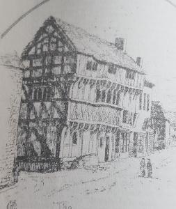
Forgot to say, post 24 is the Pilgrims Rest.
Anne, what did you mean by its heyday? The people or the buildings, what years, if people what ages ?
If you meant what did the people do for kicks between 1900-50 then I can tell you I had an aunt, teenager in the twenties, and how they copied the London crowd antics and fashions. |
| Streets and Roads - Palmer Lane | |
|
Helen F
Warrington |
28 of 139
Sat 1st Sep 2018 12:32pm
It is a good question Kaga and your stories are as correct an answer as any because it was busy in a modern sense.
As far as I can tell by modern eyes, with the exception of the original Pilgrims Rest as shown in Kaga's sketch, Palmer lane was always a bit grotty. Although it was probably quite impressive to those who lived there when it was first built, which I think must have been some of Coventry's oldest timber structures. The buildings on the east side in particular were crumbling ruins even in Dr Troughton's day and those that survived were clad in brick. The south end was almost all relatively modern by the time Trinity Street was built and they were demolished. The mid section of the west side still had jettied buildings before the war and I hope that a decent picture or two might turn up one day. But those look more modern than the structures on the east side. I have a few sketches but a photo is always good for scale and accuracy. Of the north end I'm not sure what was brick clad original or just new build.
Palmer Lane was clearly connected to the Priory and potentially related to the Saxon nunnery which had been founded c. AD 700 by St. Osburga. There are different theories as to where it had been located and the areas near to St Mary's are a possibility. Part of a stone Saxon cross was even discovered being used as part of the road surface in Palmer Lane. The name itself is about pilgrims and a great many palmer's tokens were found in the Shebourne near Palmer Lane. So the nunnery may have occupied the area or the lane may have been a small community serving it. At the very least it was probably bustling at the height of the priory but not as wealthy as the grand buildings built by the priory in the Bull Ring and on Ironmonger Row as those buildings look like late medieval structures to me. I think a lot of Palmer Lane was older. |
| Streets and Roads - Palmer Lane | |
|
Helen F
Warrington |
29 of 139
Sat 1st Sep 2018 1:23pm
Palmer Lane is a funny old area.
Now I have a theory about wonky roads and bridges. At first there were no bridges and people used fords, where the river was wider but shallower eg Smith Ford heading from Spon Street to the castle Broad Gate. Some time later they decide to build a bridge but they didn't build it over the very useful ford, they built it nearby. This spawns a new route that maybe goes to a slightly different destination eg towards the priory through the West Orchard and passed the Leather Hall. Later the ford is no longer vital and a new bridge (Ram Bridge) gets built along what is already a colonised street. I think something similar happened at Spon End, Gosford Street and Palmer Lane/the Burges. There are archaeological signs of another route cutting through Ironmoner Row between Palmer lane and the Burges and of other bridges crossing the sherbourne too, so there may have been intermediary bridges before the ones we know of from maps. Those funny little market areas at Spon End, Bishop Street and Gosford Street look like the road used to diverge but then buildings got in the way. At Gosford Street St George's Hall was built on a bridge over the river. Why? Perhaps it reused an earlier bridge? The most direct route to Far Gosford Street is through what was to become the New Inn.
  So perhaps Bishop Street originally headed straight towards the priory and the castle (or even the nunnery originally) and Palmer Lane, the Burges and Cross Cheaping came later?
 |
| Streets and Roads - Palmer Lane | |
|
Heathite
Coventry |
30 of 139
Mon 10th Sep 2018 10:20am
Taken today, any ideas?

|
| Streets and Roads - Palmer Lane | |

Website & counter by Rob Orland © 2024
Load time: 69ms