NeilsYard
Coventry
|
16 of 31
Wed 7th Mar 2018 9:35pm
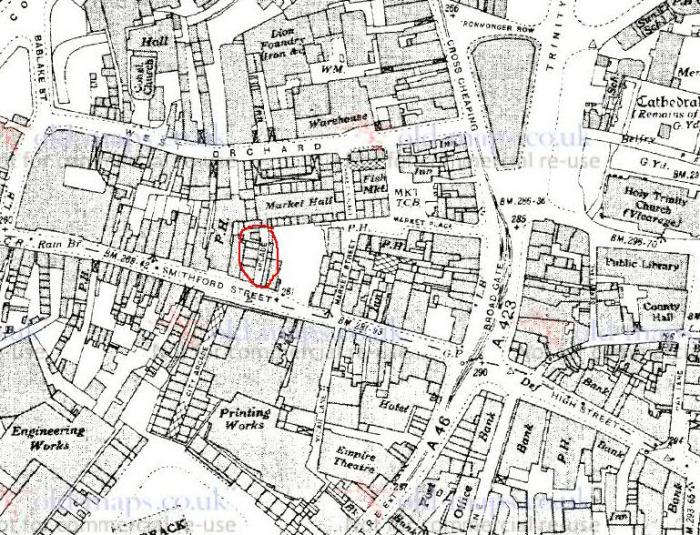
Might be totally wrong but coincidentally I was just looking at this 1937 map and noticed this 'Arcade' marked near to but opposite the City Arcade - is this Drinkwater or am I on the wrong side of Smithford Street? I can't recall noticing this one before?
|
|
Streets and Roads -
Drinkwater Arcade
|
Prof
Gloucester
Thread starter
|
17 of 31
Wed 7th Mar 2018 10:34pm
I think you are right Neils Yard and it fits with Anne Wiggy's quotation! Opposite the City Arcade. |
|
Streets and Roads -
Drinkwater Arcade
|
Annewiggy
Tamworth
|
18 of 31
Thu 8th Mar 2018 9:00am
It is marked on this map though not very clear exactly where it is. This is a strange but useful map, it is not dated but mentions Princess Elizabeths visit in 1948 so is post war, but it is a pre war map "Burrows pointer guide map of Coventry". It is very useful as it has an index and a strip that you lay across the map to find the location in the index. I have found some more references to the planned project to be carried out in the area and if the war had not intervened the area would still look a lot different to how it did then.
|
|
Streets and Roads -
Drinkwater Arcade
|
Prof
Gloucester
Thread starter
|
19 of 31
Thu 8th Mar 2018 9:15am
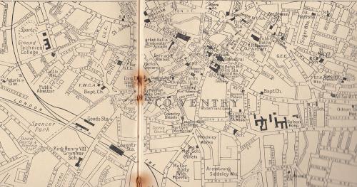
The line of the new Precinct encroached on the south side of Smithford Street, so effectively it was widened. NeilsYard's map which is easier to see as it is larger shows the White Lion (PH) and the present M & S was next to it and made the new corner into West Orchard.
My recollection is that the White Lion was demolished after when that side of the Upper Precinct was developed. So the Drinkwater Arcade must have been approximately where the escalator to the shops above now stands, though it could have been more to the left on the first map. Without copying I find the second map too small as it is to see clearly. |
|
Streets and Roads -
Drinkwater Arcade
|
Annewiggy
Tamworth
|
20 of 31
Thu 8th Mar 2018 10:52am
Sorry Prof, I did it quickly this morning and did not check if was readable. I can do it again if you want but I think you have the information from Neil's map. |
|
Streets and Roads -
Drinkwater Arcade
|
NeilsYard
Coventry
|
21 of 31
Fri 9th Mar 2018 10:00am
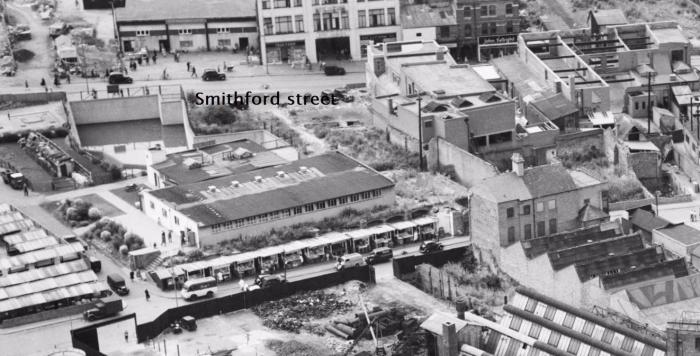
If my map was the correct spot you may find this one interesting - post war and obviously the area has been cleared but you can still see City Arcade and if right - the cleared area where Drinkwater would have been (looking across West Orchard).
 |
|
Streets and Roads -
Drinkwater Arcade
|
Annewiggy
Tamworth
|
22 of 31
Fri 9th Mar 2018 12:41pm
This was the plan in 1938.
IMPROVEMENT PLAN IN SMITHFORD STREET
Markets Committee Recommend Sale of Valuable Site
DEMOLITION OF CORN EXCHANGE AS AID TO SHOPPING CENTRE
Subject to the consent of Coventry City Council, on Tuesday, the Markets Committee will shortly carry into effect a scheme whereby they will dispose of a large and valuable site, on a 99 years' lease, in Smithford Street, enabling a further improvement to be made in one of the most popular shopping centres in the city.
The scheme includes the demolition of the Corn Exchange and the widening of the Drinkwater Arcade.
The properties belonging to the Markets Committee referred to are those which comprise the block between the White Lion Hotel and Market Street, and also certain properties on the west side of Market Street. Part of the property was recently leased to British Home Stores Ltd., whose new premises are now nearing completion. Regarding the property between the White Lion Hotel and the British Home Stores, the Committee recently invited offers for a building lease on conditions generally similar to those of the British Home Stores, and the most favourable offer recommended to the Council for acceptance is that from Cardigan Estates Ltd., of London.
DRINKWATER ARCADE WIDENING
The ground-floor space available, after allowing for a widening of Drinkwater Arcade, is approximately 637 square yards, and the lessees will have the right to erect buildings, from first-floor level upwards, over parts of Drinkwater Arcade of an area of approximately 94 square yards.
All the properties on the land, except the Corn Exchange, are used as retail shops. Four are let on leases, which will expire in 1940, and the remainder are let on annual or shorter tenancies. The annual rents from these properties amount to £1,027.
As regards the Corn Exchange, it will be necessary to obtain the consent of the Minister of Health to the proposed lease, for the scheme includes the demolition of that building.
It is intended to provide alternative accommodation for those who use the Corn Exchange on Fridays in the Market Hall, where rooms are available.
PREMIUM OF £28,000
The full recommendation to the Council proposes that, subject to the consent of the Minister of Health, Cardigan Estates Ltd. be granted a building lease on payment of a premium of £28,000 and an annual rent of £100.
The company are to make their own arrangements for obtaining vacant possession of the properties and are, in any event, to start the demolition work as soon as the last of the leases expire in September 1940, thereafter to proceed with their building scheme.
The company are to construct a new roof of a type to be approved by the Corporation over the widened Drinkwater Arcade, the cost of which will be borne by the Corporation, but which the company will maintain.
ELEVATIONS OF NEW BUILDINGS
The elevations of the new buildings are to be of terracotta or brick with stone facings, and they are to be the same height as the British Home Stores premises. The Corporation are to bear the cost of paving and lighting the Arcade, and in all other respects the conditions of the lease are to be similar to those contained in the agreement with British Home Stores Ltd.
|
|
Streets and Roads -
Drinkwater Arcade
|
Prof
Gloucester
Thread starter
|
23 of 31
Fri 9th Mar 2018 2:55pm
Most interesting to read this Annewiggy, which confirms where the Drinkwater Arcade stood. The plans were bruited in the year of my birth too! |
|
Streets and Roads -
Drinkwater Arcade
|
Prof
Gloucester
Thread starter
|
24 of 31
Wed 16th May 2018 9:14pm
Thanks Annewiggy, Neil's map makes it clear. |
|
Streets and Roads -
Drinkwater Arcade
|
TSP
W.A.
|
25 of 31
Sun 26th Aug 2018 2:57am
|
|
Streets and Roads -
Drinkwater Arcade
|
Midland Red
|
26 of 31
Sun 26th Aug 2018 8:06am
|
|
Streets and Roads -
Drinkwater Arcade
|
Prof
Gloucester
Thread starter
|
27 of 31
Wed 7th Nov 2018 3:17pm
On 7th Nov 2018 11:49am, NeilsYard said:
A good reference painting showing the gap we mentioned at the start of this thread to what was Market Street - thanks to The Coventrian FB page - Nancy Upshall (b.1927) 'Smithford Street, Coventry, 1953'.
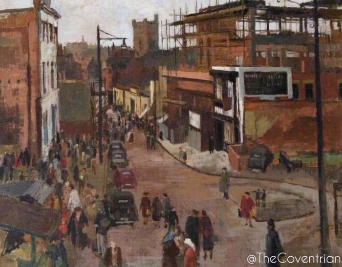
So, am I right in thinking the Drinkwater Arcade would be to the right of the picture? Just above the White Lion?
Post copied from topic Smithford Street (inc. Ram Bridge) on 10th Nov 2018 9:38 pm |
|
Streets and Roads -
Drinkwater Arcade
|
Kaga simpson
Peacehaven, East Sussex
|
28 of 31
Fri 9th Nov 2018 9:04am
Prof,
Once again the mention of a street I have never heard of and cannot find it on the maps - 'Drinkwater Arcade' - where was that? |
|
Streets and Roads -
Drinkwater Arcade
|
Heathite
Coventry
|
29 of 31
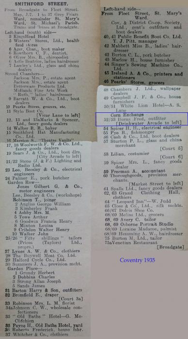
Fri 9th Nov 2018 11:49am
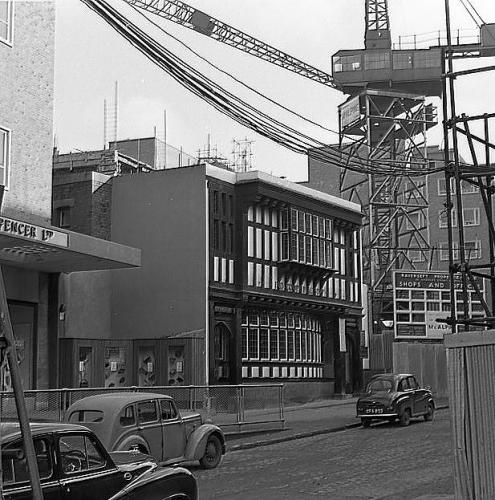
Drinkwater Arcade in Smithford Street 1935.
|
|
Streets and Roads -
Drinkwater Arcade
|
Kaga simpson
Peacehaven, East Sussex
|
30 of 31
Sat 10th Nov 2018 3:26pm
I have no idea why I mentioned Drinkwater Arcade when I did not know where Dolphin Yard and Dolphin Inn were, but Coventry in the old days had so many yards and pathways. A winding passageway ran, which led to the back way of the Three Tuns, it went along the backs of the properties there, and ended near the Castle in the corner of old Cross Cheaping. Three doors away from the High street a narrow passageway led from Broadgate to Pepper Lane. There was Malthouse Yard, The Half Moon Yard and many more. |
|
Streets and Roads -
Drinkwater Arcade
|