
|
morgana
the secret garden |
16 of 49
Tue 26th Aug 2014 3:09pm
I wouldn't be surprised at any of the council plans Pixrobin they have proved to do U turns as Philip says you can never trust liars.
As for farms ownership yes there are a lot of farms not owned by the farmer. I thought when living on a farm it was the farmer who owned the farm but it was the Keresley coal board who owned it. |
| Coventry Suburbs and Beyond - Westwood Parish (incl. Land Ownership and Development) | |
|
pixrobin
Canley Thread starter
|
17 of 49
Sat 30th Aug 2014 2:06pm
After scouring through the 1911 Census forms for Westwood I have suddenly realised that the postal addresses of many properties in the area referred to 'Coventry' or 'Nr [near] Coventry'. The Cox family who then ran 'The Peeping Tom' pub regarded themselves as living in Tile Hill, while the postal address was Westwood (as opposed to Westwood Heath), Coventry. I always assumed it was in Burton Green because it was beyond the Coventry boundary, and more importantly wasn't subject to Coventry's licensing hours. Does anyone have earlier references to postal addresses in the area? Question |
| Coventry Suburbs and Beyond - Westwood Parish (incl. Land Ownership and Development) | |
|
pixrobin
Canley Thread starter
|
18 of 49
Tue 2nd Sep 2014 12:25pm
For some months now I have been trying to find a way of imagining an acre. The original meaning of acre being what a man could plough in a day was not much help. The mention of one chain by one furlong does break it down a bit. But, you can't visualise it! I found the answer for me yesterday. We see house fronts every day - and generally the width of a terraced house is the same countrywide (16.5ft). So, a chain is the width of four terraced house, and as a furlong is 10 chains it means 40 house fronts is a furlong. For me, that means a furlong is from the front of my house to a small garage down the hill. I hope that helps others.
|
| Coventry Suburbs and Beyond - Westwood Parish (incl. Land Ownership and Development) | |
|
Mike H
London Ontario, Canada |
19 of 49
Tue 2nd Sep 2014 3:43pm
Can you put up a photo of your street, taken from your front door and including the garage at the bottom of the hill. A 50/55mm lens would be helpful from a perspective point of view..  |
| Coventry Suburbs and Beyond - Westwood Parish (incl. Land Ownership and Development) | |
| TonyS |
20 of 49
Tue 2nd Sep 2014 4:19pm
|
| Dreamtime |
21 of 49
Tue 2nd Sep 2014 4:51pm
|
|
pixrobin
Thread starter
|
22 of 49
Tue 2nd Sep 2014 6:30pm
|
|
pixrobin
Thread starter
|
23 of 49
Tue 2nd Sep 2014 6:33pm
|
| Mike H |
24 of 49
Wed 3rd Sep 2014 2:26am
|
|
pixrobin
Canley Thread starter
|
25 of 49
Sat 29th Aug 2015 8:48pm
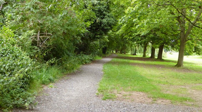
The hedgerow to the left was the boundary between Coventry and Lord Leigh's Westwood Parish prior to 1926. It is the west side of Hearsall Common between Canley Road and Tile Hill Lane (looking from Canley Road). In my youth it was defined by a row of poplars next to the Standard Triumph works.
 The boundary continued down what is now Guphill Ave to the brook at Brookside Close. Land to the north of the brook was Allesley. The boundary followed the brook through Eastern Green.
|
| Coventry Suburbs and Beyond - Westwood Parish (incl. Land Ownership and Development) | |
|
pixrobin
Canley Thread starter
|
26 of 49
Sun 6th Sep 2015 3:03pm
With recent archaeology being undertaken on the University of Warwick site it seems that the area now known as Westwood has a far richer history than is common knowledge.
Westwood prior to the Romans
|
| Coventry Suburbs and Beyond - Westwood Parish (incl. Land Ownership and Development) | |
|
flapdoodle
Coventry |
27 of 49
Sun 6th Sep 2015 6:11pm
There's pre-Roman pathways through the campus, and in Tocil Wood some pre-Roman earthworks. Further up towards the farm between the campus and Kenilworth the cycle path goes past the remains of a medieval dam that was possibly used for fish ponds by the monks at Stoneleigh, who owned the land. There's also been some roundhouses discovered up there. Warwick Uni used to have a webpage that had a guide to all this stuff. I used to go cycling round that way, mainly as it's off road. Up to Burton Green, down the greenway and through the campus.
EDIT: Ah, the website looks recent. The one a few years ago was different, more like a pdf you can download.
Interesting to see some Roman finds as well. There seems to be a persistent 'legend' that Coventry has Roman origins (as in the settlement in the city centre) yet there's never been much evidence found and the landscape suggests it's typical of the places Saxons used to settle in. |
| Coventry Suburbs and Beyond - Westwood Parish (incl. Land Ownership and Development) | |
|
NeilsYard
Coventry |
28 of 49
Sun 6th Sep 2015 8:17pm
Interesting to hear about the Romans and the Westwood boundary - thanks pixrobin  Took my youngest back up to Lunt a few weeks ago. I'm still amazed its not publicised/known more given the Gyrus there is still the only one ever discovered anywhere outside of Italy/the Roman Empire. Took my youngest back up to Lunt a few weeks ago. I'm still amazed its not publicised/known more given the Gyrus there is still the only one ever discovered anywhere outside of Italy/the Roman Empire. |
| Coventry Suburbs and Beyond - Westwood Parish (incl. Land Ownership and Development) | |
|
pixrobin
Canley Thread starter
|
29 of 49
Mon 16th Nov 2015 11:07pm
Have been looking at practicalities for my grandparents who lived in Gibbet Hill Road (close to Kirby Corner) from 1913 until after WWII. My grandfather was a farm labourer. Pre-war most of their daily needs could have been purchased locally or delivered to the door. But what of clothing and other items? Looking at old maps I note that the route to Kenilworth along Featherbed Lane is shorter than that to Coventry, though Earlsdon is closer than either. How good was shopping in Kenilworth or Earlsdon a hundred years ago? Question |
| Coventry Suburbs and Beyond - Westwood Parish (incl. Land Ownership and Development) | |
|
pixrobin
Canley Thread starter
|
30 of 49
Sat 19th Mar 2016 10:11pm
I've been doing a lot more desktop research on Westwood Parish over the winter months, I have seen many times that Coventry Corporation bought 3,500 acres from the Stoneleigh Estate in 1926. It seems that is not quite true. Yes, the City Corporation extended their boundaries by 3,500 acres into the Westwood Parish but in 1926 Lord Leigh owned only around 2,200 acres of it. They paid just under £110,000 for it (equivalent to £6m today taking inflation into account). I am now working through who owned the remaining 1300 acres.
I've also been looking at the area between the Norman invasion and the dissolution of the monasteries by Henry VIII. If you thought an acre was hard to visualise try virgate, carucate, and oxgang.
I was having a look around the area on Google Earth this afternoon with the time set to 1945 and the aerial photo coverage. At the corner of Charter Avenue and Cromwell Lane I noticed this:
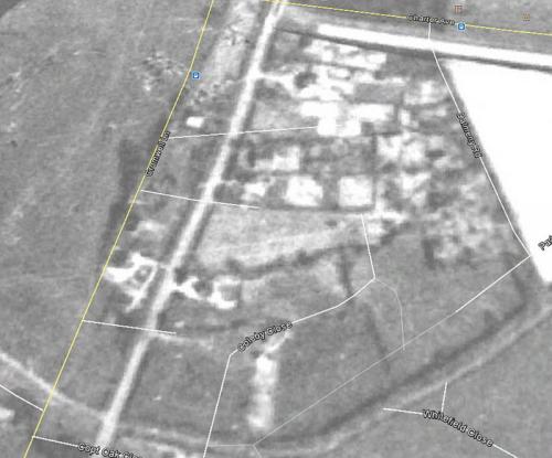 It seems a very 'busy' area for the date (though I suspect it is a year or two later). It doesn't make any sense to me. Can anyone make head or tail of it?
(Mods - the image is a screen capture from Google Earth so please delete when necessary)
It seems a very 'busy' area for the date (though I suspect it is a year or two later). It doesn't make any sense to me. Can anyone make head or tail of it?
(Mods - the image is a screen capture from Google Earth so please delete when necessary)
|
| Coventry Suburbs and Beyond - Westwood Parish (incl. Land Ownership and Development) | |

Website & counter by Rob Orland © 2024
Load time: 32ms