Helen F
Warrington
|
106 of 190
Thu 23rd Apr 2020 9:59am
Everyone agrees that the newspaper photo of the archway and the cycle shop is on the south side Kaga. The sign for Earl Street is there for those who turn out of St Mary Street, which is where the photographer was standing but isn't at the beginning of Earl Street which is where the street meets the High Street (Hay Lane/Little Park Street) and ends at Jordan Well (Bayley Lane/Much Park Street) which wasn't far east from St Mary Street.
Ah, Rob beat me to it. One of the problems with photos and maps is using left/right east/west. We tend to think that left is west and right is east but not when you're looking anything but north. It's easier if everyone looks at the same map.  |
|
Streets and Roads -
Earl Street (inc. Palace Yard)
|
Kaga simpson
Peacehaven, East Sussex
|
107 of 190
Thu 23rd Apr 2020 10:18am
Rob, Helen
If it's looking south it must be on the north side, but it's not. Yes, the Earl Stroad sign is on the end of Earl St, the last shop, Dragoon shop. |
|
Streets and Roads -
Earl Street (inc. Palace Yard)
|
Helen F
Warrington
|
108 of 190
Thu 23rd Apr 2020 10:33am
I see! No, what we mean is the image/photographer is looking south, not the building.
No, the Dragoon shop is next to the Palace Yard which is about a third of the way from the High Street*. St Mary Street is halfway along Earl Street. Star Yard is a third from the Jordan Well end.
*Earl Street doesn't start and stop at the same place on the north and south side of the road. |
|
Streets and Roads -
Earl Street (inc. Palace Yard)
|
Prof
Gloucester
|
109 of 190
Thu 23rd Apr 2020 10:41am
#102 Through the archway Helen, the window looks lower down than in the one Moriarty showed of my post. Also there seems to be no boarding. Was the window taken out and moved up?
|
|
Streets and Roads -
Earl Street (inc. Palace Yard)
|
Kaga simpson
Peacehaven, East Sussex
|
110 of 190
Thu 23rd Apr 2020 11:11am
Yes, the back of the shop was the south side. Now, if I remember correctly, the numbers ran on the north side from the High St down to Jordan Well, crossed over and came up the other side, making Dragoon cycle shop the last shop back at the High St, and then continued on in Palace Yard, so making the cycle shop almost opposite Hay Lane. |
|
Streets and Roads -
Earl Street (inc. Palace Yard)
|
moriarty
allesley park coventry
|
111 of 190
Thu 23rd Apr 2020 11:13am
I should just like to correct something if I may. The image on post 33, the Herbert, isn't where the Herbert is now, that area is Browns.
I did once go into it, it was down steps off Bayley Lane, quite like an air raid shelter! Very boring.
It's possible that this hut - post 101 - was just a rest hut for bus drivers so any notices would concern them. The clue is in Anne's post 80. Ernest Birchley (bus driver) would sketch Palace Yard which would hardly be possible if it was just a regular stop.
Helen, is it possible to bring up map 5, I don't have it. Maybe as shop frontages stay the same all the buildings could be identified, maybe even the junction with Earl St / Bayley Lane which is the area I was most interested in. |
|
Streets and Roads -
Earl Street (inc. Palace Yard)
|
Prof
Gloucester
|
112 of 190
Thu 23rd Apr 2020 11:13am
Kaga, would not St Mary St be more likely? |
|
Streets and Roads -
Earl Street (inc. Palace Yard)
|
Helen F
Warrington
|
113 of 190
Thu 23rd Apr 2020 11:30am
Prof, the window is at the same height but there is something in front of it at the bottom. It also looks like the lamp post is in front of the paving. What I think happened is the council gradually bought up bits of the plot for the Council House and did work towards it as they could. They bought up most of the front row first, put up a wooden fence and demolished what they could before widening the road as per your photo looking towards the High Street (post 31) and the three(?) buildings they hadn't acquired. I think that the building with the funny window might be a site office hut with clap board sides. Some buildings were left without an end and they were patched up. You can see a raw gable end behind the hut. For a while they tidied up the area and erected railings and moved the lamp post to the new pavement. Why was there a lamp post just there? Because it was outside a pub called the Cross Keys. Pubs always seem to be the original sites for lights. I wonder if at any point the pubs were paid for the service of street lighting or if the service to the customers was enough reward in itself?
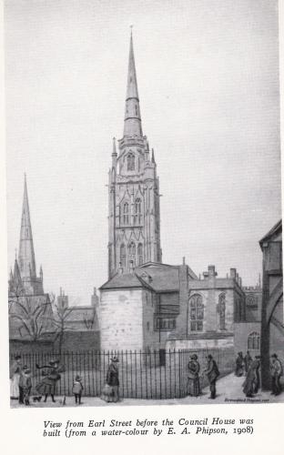
From Anne's image at post 23, I think this is after the demolition and repair stage. The building on the right is the repaired gable end (court number 2). When purchases and plans were finalised they demolished any remaining buildings with the exception of Maycocks which lasted till partway through the erection of the Council House (see post 61).
|
|
Streets and Roads -
Earl Street (inc. Palace Yard)
|
Prof
Gloucester
|
114 of 190
Thu 23rd Apr 2020 11:50am
#113 Helen, I wonder whether what you see as a site office could be the temporary replacement for Cross Keys (with some writing at the top) as in other central areas eg Warwick Lane (Grapes Inn) and West Orchard where there were some pubs with clap boarding? |
|
Streets and Roads -
Earl Street (inc. Palace Yard)
|
Helen F
Warrington
|
115 of 190
Thu 23rd Apr 2020 12:15pm
It might be a temporary pub Prof but it wasn't like the war where very few buildings still stood. There were still plenty of pubs and inns nearby. What made me think it was a site office is what looks like a notice board on the right of the window.
Moriarty, there's a link to the maps somewhere on the forum but type British Library Fire Insurance Map Coventry into Google and it will turn up.
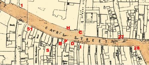
#1 = High Street junction with Earl Street on the North side, corner of Hay Lane and the Maycocks building.
#27 = Jordan Well junction with Earl Street on the North side, corner of Bayley Lane
#28 = Jordan Well junction with Earl Street on the South side, corner of Much Park Street
#51 = High Street junction with Earl Street on the South side, corner of Little Park Street
H = Site hut and view from Palace Yard archway. Former site of the Cross Keys pub
C = Where the camera was to capture the archway to the Institute of Technology. Camera was stood on the entrance to St Mary Street.
I = Institute of Technology #38
D = Dragoon Cycle Shop #39
P= Palace Yard #40
B = Book shop and Herald printers #41
S = Sword and Mace
|
|
Streets and Roads -
Earl Street (inc. Palace Yard)
|
Prof
Gloucester
|
116 of 190
Thu 23rd Apr 2020 12:26pm
This makes it all so clear Helen, thank goodness for the BLFI maps. Thank you! |
|
Streets and Roads -
Earl Street (inc. Palace Yard)
|
Prof
Gloucester
|
117 of 190
Thu 23rd Apr 2020 12:56pm
#101 Moriarty, Helen, I think that must be the bus stop sign on the lamp standard? Though, on second look, it may be a gap in the building work going on there! |
|
Streets and Roads -
Earl Street (inc. Palace Yard)
|
Kaga simpson
Peacehaven, East Sussex
|
118 of 190
Thu 23rd Apr 2020 2:45pm
Rob
Hi, how odd you looked at it as a photographer, where I looked at the photo and immediately thought that's on the south side of the street near the The Craven. I'll to have think more.
Earl Street numbered from High St north down to Jordan Well, crossed over, came up the south side, whereas Jordan Well numbered on north side to Earl St, crossed over, went down south side. |
|
Streets and Roads -
Earl Street (inc. Palace Yard)
|
Rob Orland
Historic Coventry
|
119 of 190
Thu 23rd Apr 2020 6:23pm
I understand where your confusion came in now, Kaga.
You were referring to the shop facing north (but standing on the south side of the street), whereas the rest of us, as you rightly pointed out, were referring to the view as seen through the camera - or by the viewer of the photograph - "looking" southwards towards the shop. |
|
Streets and Roads -
Earl Street (inc. Palace Yard)
|
NeilsYard
Coventry
|
120 of 190
Thu 23rd Jul 2020 9:11am
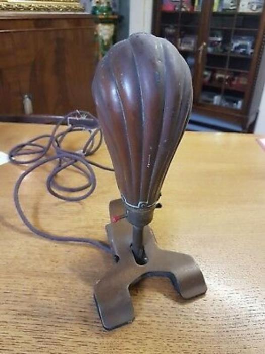
I'd heard about these before but it's the first time I've actually seen one! Graces' Guide says they were manufactured in the 1920's but not sure if they were present in the Yard up to its end.

|
|
Streets and Roads -
Earl Street (inc. Palace Yard)
|

