
|
NeilsYard
Coventry |
436 of 514
Wed 6th Jan 2021 9:48am
Helen, are those awnings on Queen Victoria Road? Looks like its covered in ivy?
Harrier, looks like that pic has been chopped down - do you have the full image? |
| Streets and Roads - Spon Street | |
|
Helen F
Warrington |
437 of 514
Wed 6th Jan 2021 9:59am
Yes, Neil, it's Queen Victoria Road and yes it's ivy. Horrible stuff. The sketch I've got roughly shows the face fronting Spon Street, without the ivy. The main door looks like it was on Holyhead Road. The house predates the Holyhead Road and was clearly on the 1749 map. It may be a contemporary with the small group of Georgian properties on Little Park Street, Priory Row and Much Park Street. |
| Streets and Roads - Spon Street | |
|
Dreamtime
Perth Western Australia |
438 of 514
Wed 6th Jan 2021 4:04pm
On 6th Jan 2021 9:30am, Midland Red said:
Not all, Mick - there were courts on the other side of Spon Street as well
Have a look at this site
Thanks MR, having no sense of direction whatsoever I found that map of the Spon area very helpful. 
|
| Streets and Roads - Spon Street | |
|
Mick Strong
Coventry |
439 of 514
Tue 12th Jan 2021 10:14am
On 6th Jan 2021 9:30am, Midland Red said:
Not all, Mick - there were courts on the other side of Spon Street as well
Have a look at this site
Thanks MR.
On the map attached to that site, it shows Fleet Street as a continuation of Corporation Street. Was this just for the length of the junction of Hill Street and Spon Street or did Fleet Street become Corporation Street as we know it today?
On current maps, Fleet Street appears as an extension to Spon Street?
Mick Strong
|
| Streets and Roads - Spon Street | |
|
NeilsYard
Coventry |
440 of 514
Tue 12th Jan 2021 11:19am
Hi Mick. It's a bit open for debate but Fleet Street traditionally ran from Ram Bridge just east of the junction with West Orchard linking Smithford Street to Spon Street where it met Holyhead Road (now Lower Holyhead Road thanks to the Ring Road). Hill Street also ran in to Fleet Street though the line of that was altered at its southern end thanks to the building of Corporation Street. It's always been a bit of a mystery to me why Fleet Street is there as there are no obvious signs of where it starts and ends like most other streets at junctions etc. I believe as far back as the 15th century it was part of Spon Street anyway. I'm sure someone on here will know why it came about. |
| Streets and Roads - Spon Street | |
|
Mick Strong
Coventry |
441 of 514
Tue 12th Jan 2021 11:58am
Hi Neil. It's strange that if you go on Google Maps and type in 192 Fleet Street, there is a sign on the building that says Spon Street, but the writing on the road shows Fleet Street. Google shows Fleet Street starting at the junction of Spon Street and Lower Holyhead Road and finishing at Corporation Street. All of 60 metres!! Mick Strong
|
| Streets and Roads - Spon Street | |
|
Helen F
Warrington |
442 of 514
Tue 12th Jan 2021 1:37pm
Fleet Street ended at the gate which was just to the west of St John's. Those buildings were outside the wall so are technically Spon Street. Holyhead Road is relatively new. What the council has designated is another matter. |
| Streets and Roads - Spon Street | |
|
NeilsYard
Coventry |
443 of 514
Tue 12th Jan 2021 1:44pm
Robs 1749 Map shows that nicely |
| Streets and Roads - Spon Street | |
|
Helen F
Warrington |
444 of 514
Tue 12th Jan 2021 1:52pm
You can see Holyhead House and the driveway/path that went to the front door. Dating the house to before 1749. |
| Streets and Roads - Spon Street | |
|
Helen F
Warrington |
445 of 514
Tue 12th Jan 2021 3:16pm
Since the area was cleared for the Civil War and probably wasn't restored until after Charles II destroyed the walls in 1662. The first building pictured in the area was a pub called His R.H. Wm (short for William) Duke of Cumberland. He lived from 1721 to 1765. On the south side of the road there was just a wall. So it occurs to me that the area cleared of houses might not have been re-occupied until the 1700s. The house isn't top notch but it wasn't a very salubrious area. Land big enough to build a decent Georgian house with garden was in short supply in the city. |
| Streets and Roads - Spon Street | |
|
CliffB
Coventry |
446 of 514
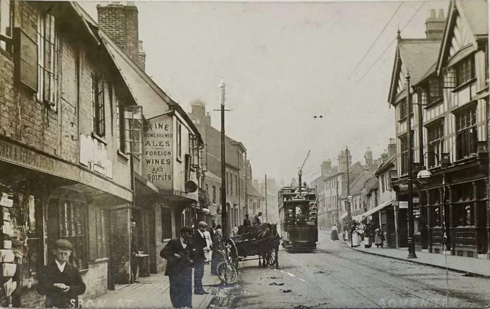
Wed 13th Jan 2021 5:13pm
A nice postcard view of Spon Street with the Recruiting Sergeant and further down the Old Windmill on the left.
|
| Streets and Roads - Spon Street | |
|
NeilsYard
Coventry |
447 of 514
Wed 13th Jan 2021 5:29pm
Thanks Cliff |
| Streets and Roads - Spon Street | |
|
Mick Strong
Coventry |
448 of 514
Wed 13th Jan 2021 5:36pm
Thanks Cliff
What a great pic. Just wondered what "Foreign Wines" would have been available? Mick Strong
|
| Streets and Roads - Spon Street | |
|
Helen F
Warrington |
449 of 514
Wed 13th Jan 2021 6:02pm
I was tempted to buy that one Cliff
Mick, I'd hope they served Pinot Grand Fenwick  |
| Streets and Roads - Spon Street | |
|
Dreamtime
Perth Western Australia |
450 of 514
Thu 14th Jan 2021 5:10am
What a classic that photo. Could be any European wines even Australian could have been well shook up by the time it reached your shores. |
| Streets and Roads - Spon Street | |

This is your first visit to my website today, thank you!
3,295,797Website & counter by Rob Orland © 2024
Load time: 45ms