
|
AD
Allesley Park |
31 of 494
Mon 28th Oct 2013 7:43pm
I agree. Why plonk an 'iconic' building in front of what is already a landmark and fabulous piece of architecture? Why couldn't they have just widened the existing street, keeping the connections to High St and Spon St, and show off this gem as the focal point at the far end of the Precinct? They wanted the view of the old spire at the other end, so why not utilise another historical church for the other? Why couldn't the tower have been built on the opposite side of Corp St where the pub/IKEA car park now is? |
| Streets and Roads - Smithford Street (inc. Ram Bridge) | |
|
Annewiggy
Tamworth |
32 of 494
Tue 29th Oct 2013 12:13pm
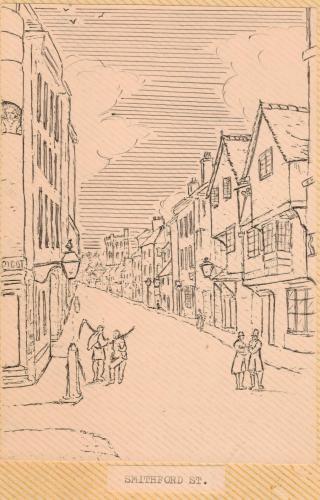
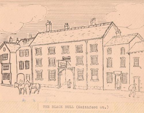
These are some sketches from my "unidentified artist" book. Smithford Street and The Black Bull Smithford Street, apparently demolished in 1793 and was where Mary Queen of Scots was confined when she arrived in Coventry.
  |
| Streets and Roads - Smithford Street (inc. Ram Bridge) | |
|
Annewiggy
Tamworth |
33 of 494
Tue 29th Oct 2013 12:50pm
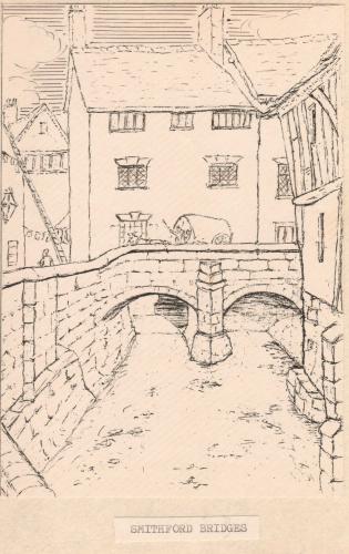
This sketch says Smithford Bridge but according to the list of Coventry Streets on British History Online it later became known as Ram Bridge. Wonder if the did a Health and Safety risk assessment on the ladder on the left!
 |
| Streets and Roads - Smithford Street (inc. Ram Bridge) | |
|
Midland Red
|
34 of 494
Tue 29th Oct 2013 2:54pm
Link to a write-up about The (Black) Bull  |
| Streets and Roads - Smithford Street (inc. Ram Bridge) | |
|
Helen F
Warrington |
35 of 494
Tue 29th Oct 2013 4:56pm
Anne, from the other images of the Smithford area bridges I've got, I think that might be a picture of the bridge on West Orchard, looking north.
The picture of the Bull is very similar to one done by Dr Troughton. That picture is supposed to be a copy of an earlier picture 'in the possession of Mr Burrows'. So are these early sketches by Dr Troughton, pictures Dr Troughton copied or copies of Dr Troughton by some unknown? Whatever, they're great. |
| Streets and Roads - Smithford Street (inc. Ram Bridge) | |
|
NeilsYard
Coventry |
36 of 494
Fri 1st Nov 2013 3:43am
I asked the question on another thread recently about how visible the Sherbourne was from Smithford Street - I was under the impression it was covered even in the days back then. However I was speaking to a 70+ year old gent at the weekend and he says the Sherbourne was quite visible going over the bridge along lower Smithford Street. Just wish I had a photo. |
| Streets and Roads - Smithford Street (inc. Ram Bridge) | |
|
Helen F
Warrington |
37 of 494
Fri 1st Nov 2013 11:39am
Coventry has been hiding its river for ages.
The bottom view by William Henry Brooke (1772-1860) in this pair is looking north from Ram Bridge to a row of houses spanning the river between Smithford and West Orchard.
 The top picture looks at the same houses from West Orchard.
The bottom one of these pictures looks (I think) west along West Orchard with the building in Anne's picture on the right and the wall of the bridge on the left.
The top picture looks at the same houses from West Orchard.
The bottom one of these pictures looks (I think) west along West Orchard with the building in Anne's picture on the right and the wall of the bridge on the left.
 There are pictures of the West Orchard bridge from the south by Sydney John Bunney (1877-1928) that show a building on the north side of the bridge and a curving wall on the south. I suspect the middle bridge with the houses had gone by this point.
Dr Troughton may be the artist of Anne's picture but I know he did draw Fleet Street looking east and it shows a gap where the bridge would have been to the north with what could be either a wall or the remains of a building. The south side of Smithford Street seems to have been built upon since earliest times.
On that side of Smithford road the river went under two doors along from the Old Baths but this is one of the bits I have no decent picture of. This picture shows the building on the north side of Ram Bridge, just to the right of the Britannia Music Hall.
There are pictures of the West Orchard bridge from the south by Sydney John Bunney (1877-1928) that show a building on the north side of the bridge and a curving wall on the south. I suspect the middle bridge with the houses had gone by this point.
Dr Troughton may be the artist of Anne's picture but I know he did draw Fleet Street looking east and it shows a gap where the bridge would have been to the north with what could be either a wall or the remains of a building. The south side of Smithford Street seems to have been built upon since earliest times.
On that side of Smithford road the river went under two doors along from the Old Baths but this is one of the bits I have no decent picture of. This picture shows the building on the north side of Ram Bridge, just to the right of the Britannia Music Hall.
 Before Corporation Street was built (some time before 1939) the whole area between West Orchard and Smithford Street was rebuilt and completely covered over. For a while the view to the north of West Orchard was open because the buildings were demolished.
After the bombing, the south side of the river may have been visible from Smithford Street. The buildings to the north of West Orchard were definitely destroyed and the river would have been visible again.
Before Corporation Street was built (some time before 1939) the whole area between West Orchard and Smithford Street was rebuilt and completely covered over. For a while the view to the north of West Orchard was open because the buildings were demolished.
After the bombing, the south side of the river may have been visible from Smithford Street. The buildings to the north of West Orchard were definitely destroyed and the river would have been visible again.
|
| Streets and Roads - Smithford Street (inc. Ram Bridge) | |
|
NeilsYard
Coventry |
38 of 494
Thu 4th Feb 2016 9:13am
Here's two cracking images that I'd not seen before with these exact views, looking down Smithford Street towards Fleet Street. Includes the City Arms Pub and the original Woolies. Thanks to Debbie@ the True Cov FB page.

 |
| Streets and Roads - Smithford Street (inc. Ram Bridge) | |
|
dutchman
Spon End |
39 of 494
Thu 4th Feb 2016 11:35am
Great pictures NeilsYard
but the original Woolies was destroyed in the war. The building on the left is the temporary store which replaced it while the building with the F.W. Woolworth & Co Ltd nameplate on the side is the City Arcade.  |
| Streets and Roads - Smithford Street (inc. Ram Bridge) | |
|
NeilsYard
Coventry |
40 of 494
Thu 4th Feb 2016 1:43pm
Thanks Dutchman - I always thought the City Arcade was on the other side of the road for some reason. |
| Streets and Roads - Smithford Street (inc. Ram Bridge) | |
|
dutchman
Spon End |
41 of 494
Thu 4th Feb 2016 5:49pm
I'm intrigued by those side roads opposite the city arcade and Woolworths, I've not seen them before on any picture or map. I suspect they lead to and from the West Orchard Market.
|
| Streets and Roads - Smithford Street (inc. Ram Bridge) | |
|
Helen F
Warrington |
42 of 494
Fri 5th Feb 2016 8:52am
Well spotted Dutchman. It's what remained of Market Street. You can just about see it on the Britain From Above site. It's a little D shaped traffic island with a direction sign on a striped pole.
Those are good photos Neil. Most images look towards the market from that era. Those help orientate where things were on the two sides of the road. |
| Streets and Roads - Smithford Street (inc. Ram Bridge) | |
| NeilsYard |
43 of 494
Fri 5th Feb 2016 9:05am
|
|
Helen F
Warrington |
44 of 494
Fri 5th Feb 2016 9:50am
It looks like it's the north west corner of the south block of the upper precinct. It was being built at that time and that block bridged the old road. The gap between the north and south blocks doesn't quite overlay Smithford Street. Almost opposite Market Street was Vicar Lane which would be just under the camera view on the left. Without a contemporary map I can't see if the roads followed their original routes.
|
| Streets and Roads - Smithford Street (inc. Ram Bridge) | |
|
NeilsYard
Coventry |
45 of 494
Fri 5th Feb 2016 10:56am
Thanks Helen - I did find a map tool which overlays maps which I'll try to find again and post. I'm 99% certain they don't. If you look at old imagery the east end of Smithford Street at Broadgate met at the Kings Head Hotel in line with the columns on today's Nat West Bank when that was built. The same line today goes through what is now Deichman Shoes which is underneath Broadgate House. I don't think I've seen many photos of Vicar Lane - my next challenge!  |
| Streets and Roads - Smithford Street (inc. Ram Bridge) | |

Website & counter by Rob Orland © 2024
Load time: 30ms