
|
Foxcote
Warwick Thread starter
|
16 of 119
Wed 30th Jan 2013 9:31am
The BTH factory in Coventry was in Alma Street I think. scrutiny said the BTH logo on that building on the original photo was on the wrong side. So does it now confirm Alma Street on the left? |
| Town Planning and Development - Aerial views of Coventry | |
|
scrutiny
coventry |
17 of 119
Wed 30th Jan 2013 10:28am
I have really studied the pic through a magnifying glass. MR, the pic would now be the right way round to put the BTH building in the right place. However, I cannot see the Read Street factory which should stick out like a sore thumb and the bottom row of windows, even giving the height of the photo, should be blanked out by the garden walls and houses which backed onto the factory. When playing down that entry you had nothing on the skyline to look at.  |
| Town Planning and Development - Aerial views of Coventry | |
|
Rob Orland
Historic Coventry |
18 of 119
Wed 30th Jan 2013 3:47pm
On 30th Jan 2013 8:35am, Midland Red said:
OK - is this how it should look?
Yep, spot on - it now looks correct that way round. (Hope you didn't mind me annotating it a bit !) Right at the bottom, towards the right-hand-side, you can see the pinnacles and a trapezium shaped part of the roof of the apse at the far end of the cathedral.
I'm also wondering if the large dark block that's just about in picture on the far right, about three-quarters of the way up, is the old DHSS building in Gosford Street?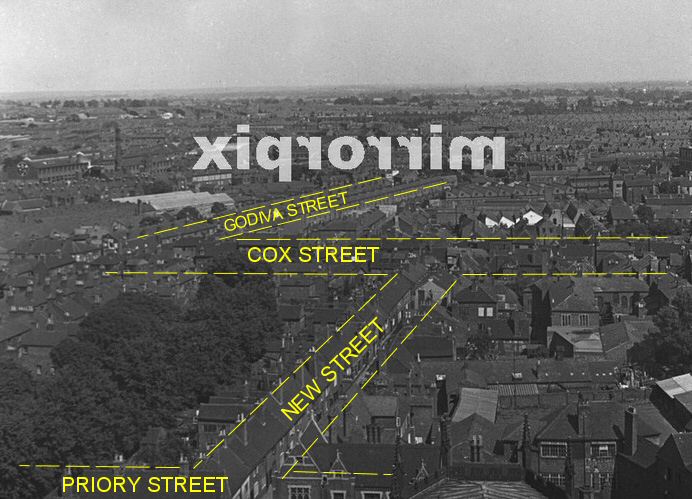 If so, please can you identify a point for me to understand where we are looking? Thanks
  |
| Town Planning and Development - Aerial views of Coventry | |
|
Foxcote
Warwick Thread starter
|
19 of 119
Wed 30th Jan 2013 3:56pm
Bravo to all of you  I can see that Geoff at Stratford, our new member is going to be really helpful on the Forum!
This one turned out to be right struggle! I do try to find mystery shots for some interest but I never thought this one was a mystery when I posted it. Sorry to cause so much trouble! I can see that Geoff at Stratford, our new member is going to be really helpful on the Forum!
This one turned out to be right struggle! I do try to find mystery shots for some interest but I never thought this one was a mystery when I posted it. Sorry to cause so much trouble! |
| Town Planning and Development - Aerial views of Coventry | |
|
dutchman
Spon End |
20 of 119
Wed 30th Jan 2013 4:23pm
On 30th Jan 2013 3:47pm, Rob Orland said:
I'm also wondering if the large dark block that's just about in picture on the far right, about three-quarters of the way up, is the old DHSS building in Gosford Street?
Yes Rob or the Morris Engine Works as it was at the time. The factory between it and Godiva Street is the Morris gearbox works (formerly Alpha Motors).
|
| Town Planning and Development - Aerial views of Coventry | |
|
Midland Red
|
21 of 119
Wed 30th Jan 2013 4:49pm
On 30th Jan 2013 3:47pm, Rob Orland said:
Yep, spot on - it now looks correct that way round. (Hope you didn't mind me annotating it a bit !) Right at the bottom, towards the right-hand-side, you can see the pinnacles and a trapezium shaped part of the roof of the apse at the far end of the cathedral.
Thanks for that, Sir - I'd seen the bits of the cathedral, but I couldn't really identify any location beyond - I'd worked out where Priory Street and Cox Street might be, but Godiva Street threw me, as it stuck out so vividly on the image but it wasn't a street that I knew that much about (just viewed your Historic Coventry street maps which clearly show the length of that street in its hey-day) |
| Town Planning and Development - Aerial views of Coventry | |
|
dutchman
Spon End |
22 of 119
Wed 30th Jan 2013 4:57pm
On 30th Jan 2013 4:49pm, Midland Red said:
Godiva Street threw me, as it stuck out so vividly on the image but it wasn't a street that I knew that much about
I only recently noticed myself that Godiva Street consisted entirely of watchmakers houses with two storeys at the front and a third at the back. You can also see that the chimney stacks in New Street nearest the cathedral are unusually high which suggests the roofs there were originally thatched.
|
| Town Planning and Development - Aerial views of Coventry | |
|
Foxcote
Warwick Thread starter
|
23 of 119
Wed 30th Jan 2013 5:22pm
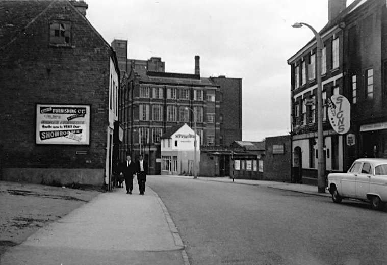
A photograph of New Street with the high pitched roof.
A photograph of Priory Street with the same building showing on the aerial view? |
| Town Planning and Development - Aerial views of Coventry | |
|
Foxcote
Warwick Thread starter
|
24 of 119
Wed 30th Jan 2013 8:18pm
View from the Cathedral towards Earl Street, c.1940
|
| Town Planning and Development - Aerial views of Coventry | |
|
flapdoodle
Coventry |
25 of 119
Thu 31st Jan 2013 12:01am
Interesting picture. Quite a lot of damage in that area, but beyond the cinema it looks fairly intact. |
| Town Planning and Development - Aerial views of Coventry | |
|
dutchman
Spon End |
26 of 119
Thu 31st Jan 2013 12:48am
It wasn't Flapdoodle I promise you, "intact" I mean.
The area around Whitefriars Lane was totally obliterated as was the top end of Cox Street and the gap between the Colin Campbell and the Oak was once a pair of furniture dealers and a courtyard before the 1940 Blitz.
|
| Town Planning and Development - Aerial views of Coventry | |
|
flapdoodle
Coventry |
27 of 119
Thu 31st Jan 2013 1:20am
Gosford Street beyond the cinema looks to have substantial buildings still remaining on that picture, though (which is what I meant). Certainly more than Jordan Well/Earl Street.
I always wondered what was in that gap.
|
| Town Planning and Development - Aerial views of Coventry | |
|
dutchman
Spon End |
28 of 119
Thu 31st Jan 2013 12:49pm
The top end of Gosford Street survived and flourished even after the war. The middle section was less fortunate as can be seen from Mike Tyzack's picture on the site taken in 1965. Almost everything between the Mermaid Inn and the Old Morris was destroyed. You can also see that the top floor of many of the buildings which did survive was often burned out. The gap on the left isn't bomb damage though, just the forecourt of a former baptist chapel.
 |
| Town Planning and Development - Aerial views of Coventry | |
|
mick
coventry |
29 of 119
Thu 31st Jan 2013 4:10pm
Godiva Street was a new street built in 1898 so it was probably a bit late for the watchmaker trade. There were other examples of the 'two storey front, three storey at the back' built around this time [Vine Street possibly?] and I suspect it was just another way keeping the plot dimensions and achieving an extra bedroom. |
| Town Planning and Development - Aerial views of Coventry | |
|
mick
coventry |
30 of 119
Thu 31st Jan 2013 4:14pm
Interesting to see the outline of the original Herbert Museum which was used postwar as a temporary gallery and eventually as a public convenience! |
| Town Planning and Development - Aerial views of Coventry | |

This is your first visit to my website today, thank you!
3,283,467Website & counter by Rob Orland © 2024
Load time: 36ms