
|
Annewiggy
Tamworth |
136 of 163
Tue 26th Apr 2022 10:59am
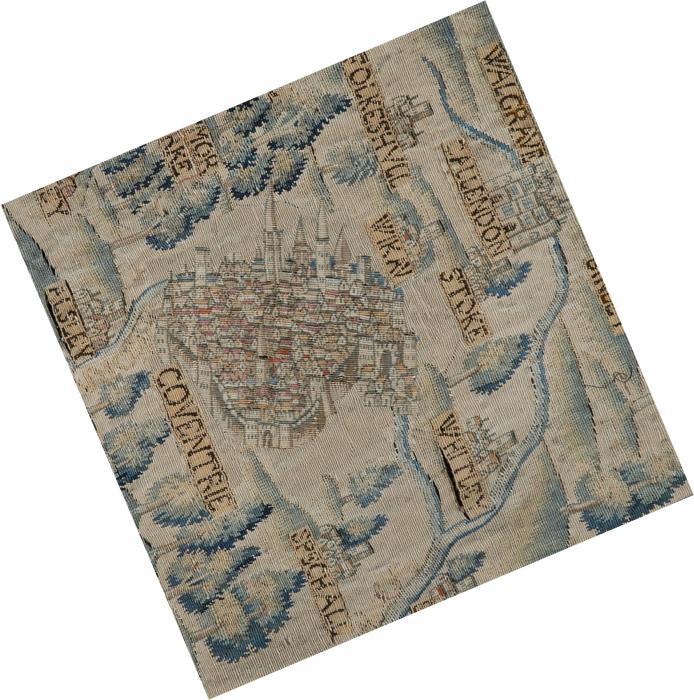
Now my brain works and I have got it. If we could rotate the Coventry city bit anti clockwise 90 degrees that would put all the suburbs including Allesley in the right places. Then turning the whole map 90 degrees clockwise it would put north in the correct place ! I am sure one of our clever computer bods could do that. Just looking at Tamworth on the map it is the same, |
| Local History and Heritage - Maps of Coventry | |
|
Helen F
Warrington |
137 of 163
Tue 26th Apr 2022 12:42pm
A bit more like this?
 |
| Local History and Heritage - Maps of Coventry | |
|
Helen F
Warrington |
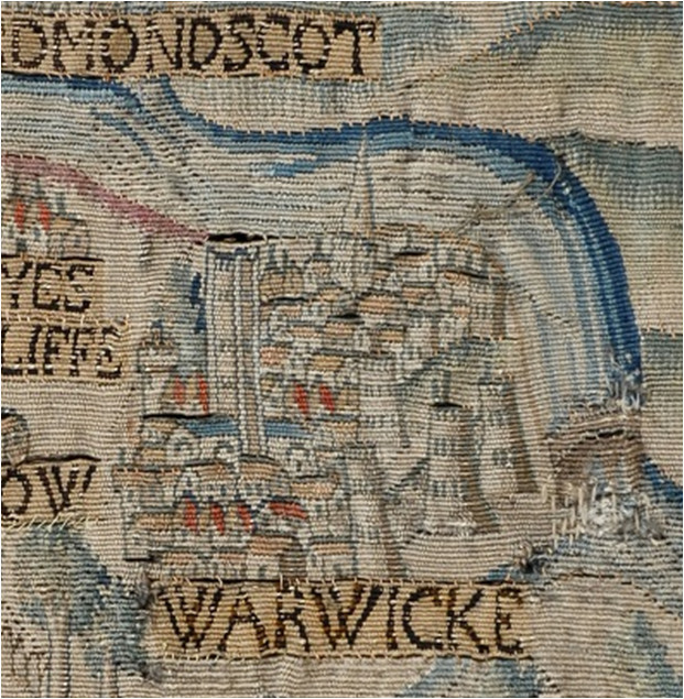
138 of 163
Tue 26th Apr 2022 1:12pm
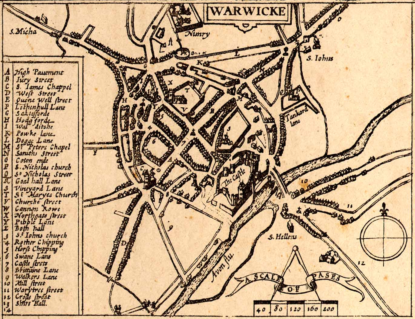
This is Warwick and it gets the castle on the right side and churches on the north (St Mary) and south (St James) but the spired church and the one without are swapped. Though the spired church could be St Peters and what looks like a wall tower on the left could be St Mary's. Note the depiction of the southern church, very similar to Holy Trinity in Coventry, so maybe it was a weavers choice to add a bit of variety as to how the churches were depicted and not a reflection of actual style? Sadly I think this makes it less likely that the Coventry tower might be the prison/keep, although I still think the location is there. The relation of height of castle to church towers does indicate the exaggeration for religious effect. The long destroyed bridge is on the right. I include the Speed map for comparison. Since the view is looking from the south, it's not odd that the southern church is portrayed as bigger than the one in the north.
 |
| Local History and Heritage - Maps of Coventry | |
|
bk
Coventry |
139 of 163
Tue 11th Oct 2022 12:43pm
I'm unsure whether many of you know this so I thought I'd post here. A few years ago I created Coventry Atlas, with the aim of putting images of Coventry alongside heritage maps, which would be plotted against a basemap.
The Board of Health maps are a good example of what I've been up to.
I'm trying to get the City of Culture team to continue to pay for this - any comments, good or bad, would be most welcome.
Ben b p kyneswood
|
| Local History and Heritage - Maps of Coventry | |
|
NeilsYard
Coventry |
140 of 163
Tue 11th Oct 2022 2:19pm
I'm lovin' all your stuff, Ben, but I find that a little confusing. There is almost too much content all at once and working between the overlays is not so straightforward. |
| Local History and Heritage - Maps of Coventry | |
|
bk
Coventry |
141 of 163
Tue 11th Oct 2022 3:23pm
Hi Neil
If you look at the overlay tools at the bottom (black rectangle), you can choose the eye icon to hide or show a particular map, as well as the adjust the transparency. The titles are by Culture Coventry, not me!
The main thing is these are large files so we get very good detail when zoomed in close. As these are the maps from the Architecture and Planning office, you'll see pencil drawings on many for where roads, etc are planned.
I've put up quite a few overlays and have more to publish - I just need the time to get on with it. b p kyneswood
|
| Local History and Heritage - Maps of Coventry | |
|
Helen F
Warrington |
142 of 163
Tue 11th Oct 2022 5:16pm
It's a fantastic resource Ben but very difficult to perfect. It hinges partly on what people want from the maps and/or the images.
Many of us used Old-Maps. It was very handy to step forwards and backwards on the same spot to read house or court numbers and see what changed over time. The Library of Scotland maps do a similar role but not as extensively. By the slightly inaccurate nature of the maps they can't be 100% point for point but it's helpful to not have to keep finding the same place on a later/earlier map. One issue - when I tried to improve the quality on the BOH maps using the controls, it worked but I didn't know which map to adjust so had to adjust them all.
One thing that is sometimes needed is a ready way to find an obscure street, court or yard on the old maps that are no longer there. In the BOH maps of 1850 the yards were named but later they were just assigned numbers. Small streets were sometimes only there briefly, especially if they were bombed or in the way of a new road. Sometimes I don't even know which part of the city to start looking for a bit of road.
Connecting photos to a map is interesting but requires the same sort of ability to include and exclude pictures based on a search. It might be nice to link photos to individual courts or stretches of street. In an ideal world the photos would have an accurate view point, direction and era. At the moment there is a risk of too many images to see the one I might want. |
| Local History and Heritage - Maps of Coventry | |
|
bk
Coventry |
143 of 163
Tue 11th Oct 2022 5:47pm
Thanks Helen - you're not the first to raise this.
The system allows for textual searching of the maps - the same as images - so if all streets in the map were named, a search should bring up the specific map you're after. I've only put the main streets in, which isnt what you're after. Perhaps when I have five minutes I'll work on the BOH maps specifically to add in all wordson the maps as searchable text. I migth rename them but need Culture Cov's permission - the titles are their designated name in their system.
The photos are very difficult. The GPS can be perfect but a map can render it 20 ft out, just because of the software.
As ever, I'll keep working on this - if there's ever anything you're after, let me know. b p kyneswood
|
| Local History and Heritage - Maps of Coventry | |
|
Helen F
Warrington |
144 of 163
Wed 12th Oct 2022 12:50am
You're doing a grand job, these are only observations.  I definitely don't want to make more work for you. Just keep making old images available and I'm a very happy bunny.
My goal is relatively limited compared to what you're trying to do. I have a much smaller area to consider and the older the better. I can cut out bits of images and then link them to specific map locations but with little arrows pointing out the features, not anything sophisticated. I can step through images to show how a feature persists from an old sketch to a later photograph and thus peg a long vanished building to a recognisable map location. You post an old map of a stretch of the river and suddenly I can identify which mill I'm looking at in a sketch. As a data map I can make sense of all that information but I can't imagine how to do it digitally. I definitely don't want to make more work for you. Just keep making old images available and I'm a very happy bunny.
My goal is relatively limited compared to what you're trying to do. I have a much smaller area to consider and the older the better. I can cut out bits of images and then link them to specific map locations but with little arrows pointing out the features, not anything sophisticated. I can step through images to show how a feature persists from an old sketch to a later photograph and thus peg a long vanished building to a recognisable map location. You post an old map of a stretch of the river and suddenly I can identify which mill I'm looking at in a sketch. As a data map I can make sense of all that information but I can't imagine how to do it digitally. |
| Local History and Heritage - Maps of Coventry | |
|
Helen F
Warrington |
145 of 163
Wed 26th Apr 2023 8:11pm
Map of Warwickshire 1722-1725
Another cracker by Henry Beighton. Links to the British Library collection. The names and coats of arms are probably the people who financed the endeavour and/or are the who's who of the area. Thomas Wright of Coventry is there at 276 f8.
Some other maps and Coventry stuff off to the right. |
| Local History and Heritage - Maps of Coventry | |
|
Helen F
Warrington |
146 of 163
Thu 27th Apr 2023 3:38pm
A lot of the names on the map were in the Thomas White charity - Coventry branch, here.
One interesting name is Hanson Norton, who seems to have owned the building that became the 'Cottage' pub on St John's Street and the buildings either side. Looking at the building to the right (two by the time the photo was taken), it may have all been built at the same time as the Cottage. The Cottage getting a face lift when it became the pub. If it was built in the early 1700s then it may have looked a lot like Kirby House, albeit on a smaller scale. There are a number similar buildings dotted round the city with brick pillars that would have looked very different with fresh red brick walls and plaster decorated pillars. By the time they were photographed the plaster decorations had been removed and the walls were looking very dodgy.
|
| Local History and Heritage - Maps of Coventry | |
|
lindatee2002
Virginia USA |
147 of 163
Thu 27th Apr 2023 5:47pm
Thank you, Mr.(Ms.?) Hotchkiss for dating your photo. |
| Local History and Heritage - Maps of Coventry | |
|
Helen F
Warrington |
148 of 163
Thu 27th Apr 2023 5:53pm
Hi Linda, I believe that the company manufactured armaments? |
| Local History and Heritage - Maps of Coventry | |
|
Annewiggy
Tamworth |
149 of 163
Thu 27th Apr 2023 7:05pm
Thank you for the interesting maps Helen. I am afraid I have drifted off the subject of Coventry and looked at Tamworth. I was fascinated to see the name of Stretford. Some time ago I started to look at the history of the place where I live called Twogates. Dugdale mentions Stretford he had found in old documents. It no longer exits and I had no idea just where it was but thanks to your map I now know. The other thing we were looking into a few weeks ago was toll roads and it is interesting to see the toll bars marked on one of the maps. I am sure next time I look at them I will find lots more of interest ! Thanks again |
| Local History and Heritage - Maps of Coventry | |
|
Dreamtime
Perth Western Australia |
150 of 163
Fri 28th Apr 2023 3:54am
Helen, because I have a very large screen on my Acer comp. I have wonderful views of your posts (and lovely and clear) as most of them on HCF. Thanks to everyone. There is so much time and effort spent on making Rob's forum as special as it is. Like Anne, I send my heartfelt thanks too.
PS. I shall continue looking for clocks, even new ones.  |
| Local History and Heritage - Maps of Coventry | |

This is your first visit to my website today, thank you!
3,303,097Website & counter by Rob Orland © 2024
Load time: 40ms