Kaga simpson
Peacehaven, East Sussex
|
76 of 115
Wed 20th Mar 2019 9:11am
The tithe barn was near the corner of Binley Road and the ground had once been enclosed, but the barn was of considerable size so to me that means very large beams and cross sections, so also a wooden affair throughout. In a bad state of repair, let in the wind and rain when the plays were performed and they acted without scenery and obviously with real swords or whatever for it to kill the actor.
I would assume when they removed the barn they had to go deep thus causing the depression that was there for years.
Yes the land was owned by Trinity Church, but it was they that let it get into disrepair as they do with many things.
And as Annewiggy posted the people contributed to the buying of the land in the end.
I posted once before, if we could see church documents we wouldn't need a history forum, they have the key to everything that went on officially.
|
|
Streets and Roads -
Gosford Green
|
scrutiny
coventry
|
77 of 115
Wed 20th Mar 2019 11:07am
On 18th Mar 2019 5:50pm, Helen F said:
I'm always getting the Street, Road, Lane, Row bits wrong.
This is for Helen F or anybody else. I found this to be very helpful when driving years ago.
Roads lead to somewhere, from centre to centre so all roads lead in and out, ie, Coventry Road on the Rugby side and Rugby Road on the Coventry side.
Lanes lead off the roads to, say, Barby, so from Rugby it is Barby Lane running off the Dunchurch Road, from Barby it is Rugby Road. Mostly on the outskirts. Dunchurch Road also becomes Rugby Road at Dunchurch.
Streets are when you get towards the centre dotted all over the place.
At this point you stop at a garage and ask if they have a street map, in years gone by most did.
Because everywhere has grown in size this has gone a bit by the wayside but is still a good guide as the original Roads, Lanes, Streets are still there.  |
|
Streets and Roads -
Gosford Green
|
Helen F
Warrington
|
78 of 115
Wed 20th Mar 2019 1:39pm
Makes sense, thanks but it's the fuzzy naming once you get off the main roads that throws me  Not to mention that they changed names on a regular basis. St John's Street is Dead Lane on the older documents I'm using and in a different place to where it is now. St Mary's Street was Half Moon Lane and before that the drapery. 'New' means anything but. Most of the artists had only a vague idea where they were when they created pictures, so many of them are mislabelled. Even John Speed had trouble, listing Glowers Lane in the index and then failing to mark it on the map and by the time the lane was identified, it's called Miller Lane. I swear that someone did it deliberately to confuse me.
|
|
Streets and Roads -
Gosford Green
|
Heathite
Coventry
|
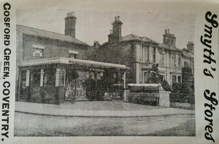
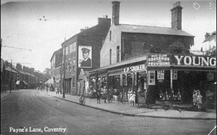
79 of 115
Wed 20th Nov 2019 2:12pm
Hi, apparently this is an image of number one Walsgrave Road in 1911.
So it must be Paynes Lane to the left.
|
|
Streets and Roads -
Gosford Green
|
Wearethemods
Aberdeenshire
|
80 of 115
Wed 20th Nov 2019 2:20pm
So was the house next door to Smyth's demolished/bombed for it to become 'Riddy's Surplus Store in the early 60's?
|
|
Streets and Roads -
Gosford Green
|
NeilsYard
Coventry
|
81 of 115
Wed 20th Nov 2019 2:24pm
This is a 1905 map - the row of houses to the right was known as Gosford Terrace -

The row survived I believe but were modified with shop fronts (photo circa '80's inc. the White Lion pub) -
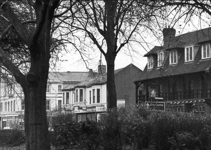
This is the same corner -
 |
|
Streets and Roads -
Gosford Green
|
NeilsYard
Coventry
|
82 of 115
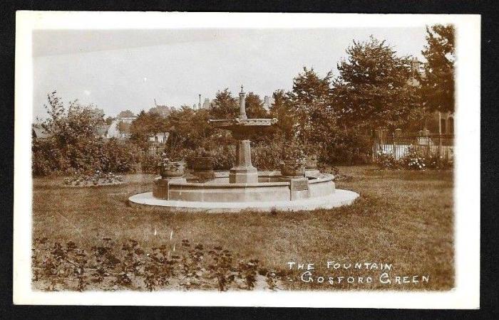
Tue 26th Nov 2019 9:42am
It's only taken about 7 years for a better image of Gosford Green fountain to turn up (as per Dutchman's comments at the start of this thread!). Thanks to Dean Nelson on the True Cov FB page -
|
|
Streets and Roads -
Gosford Green
|
Dreamtime
Perth Western Australia
|
83 of 115
Tue 26th Nov 2019 4:02pm
That's ringing a few bells for me Neil thanks. I used to cut through the top corner of the park there to get to King Richard St. from Folly Lane School.
Am I really that old ?  |
|
Streets and Roads -
Gosford Green
|
NeilsYard
Coventry
|
84 of 115
Tue 26th Nov 2019 4:28pm
There has been some feedback on FB that local radio did some research in the 1980's (Jon Gaunt?) and they determined the fountain ended up in a large house in Little Virginia near London though I think they may mean Virginia Water. No evidence or images I can find to support that or even the reasons why but...
Helen, are you aware of a St Margaret's Chapel near that spot (as per my map above in post 81)? Plenty of old maps state it was the site of at one time.
From British History -
A chapel on Gosford Green was first mentioned in 1425 when the leet ordered the chamberlains to lease the grass and garth belonging to it. It appears to have been attached to or even identical with the hermitage, said to be outside Gosford Gate, the occupants of which were, by order of leet in 1429, to be installed by the mayor. In 1446 the leet granted the hermitage to John Thorpe, tailor, on condition that he should keep it in repair. According to the agreement of 1456 the Vicar of Holy Trinity was to receive inter alia the oblations and obventions of ST. MARGARET'S Chapel, 'newly erected at Gosford Green', and in 1535 a sum of 2s. from the garden 'commonly called the chapel yard of the chapel or hermitage of St. Margaret' was included among the profits of Holy Trinity vicarage.
Cannot see any other info about when it went and why - or images. |
|
Streets and Roads -
Gosford Green
|
Prof
Gloucester
|
85 of 115
Tue 26th Nov 2019 5:27pm
I imagine you are NOT old Dream but TIMELESS! |
|
Streets and Roads -
Gosford Green
|
Prof
Gloucester
|
86 of 115
Tue 26th Nov 2019 5:34pm
As you say Neil, it appears on old maps but explains why the later St Margaret's, Walsgrave Road was so named! |
|
Streets and Roads -
Gosford Green
|
Kitty
coventry
|
87 of 115
Fri 18th Jun 2021 2:35pm
That wouldn't be Little Virginia, Kenilworth? |
|
Streets and Roads -
Gosford Green
|
NeilsYard
Coventry
|
88 of 115
Fri 18th Jun 2021 3:07pm
No Kitty. There are plenty of images of that being restored on Historic England by Sapcote the Builders during the early 70's. No fountain there. |
|
Streets and Roads -
Gosford Green
|
Helen F
Warrington
|
89 of 115
Fri 18th Jun 2021 3:23pm
On 26th Nov 2019 4:28pm, NeilsYard said:
Helen, are you aware of a St Margaret's Chapel near that spot (as per my map above in post 81)? Plenty of old maps state it was the site of at one time.
Cannot see any other info about when it went and why - or images.
Thanks Neil, yes I'd spotted where it was but confirmation always helps
Re the fountain, there were a lot of years between the postcard and the 70s renovation of Kenilworth Little Virginia. It could have moved, and then moved again. Fountains are very attractive but a pain in the rear... garden. |
|
Streets and Roads -
Gosford Green
|
NeilsYard
Coventry
|
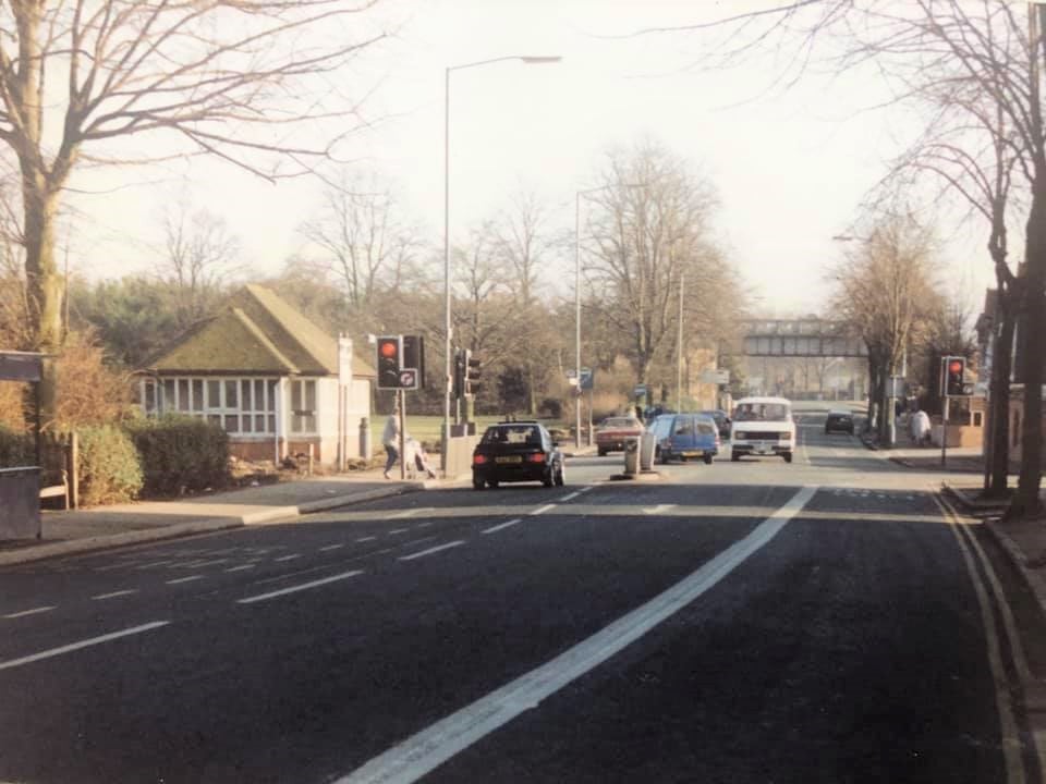
90 of 115
Tue 29th Mar 2022 11:47am
Another good one from Dean Nelson on FB. Binley Road looking east. Notice the old Loop Line bridge that is now the A444 bypass, and I'd forgotten about those loos!
 |
|
Streets and Roads -
Gosford Green
|

